

Objectives of the service
Vehicles with advanced driver assistance systems (ADAS) and autonomous driving technology often face limitations during harsh weather conditions such as heavy rain, fog, or strong winds. Onboard sensors like cameras and radars can struggle to detect hazards in time, forcing the system to hand over control to the driver or stop completely—sometimes too late to avoid risk.
We aim to solve this by providing real-time, route-based weather forecasts that give vehicles early warning of weather hazards along their planned route. Our system predicts rain intensity, wind gusts, and slippery road conditions with high accuracy and sends this information to the vehicle in time to support safer decisions.
During the Kickstart business feasibility study, user needs and pain points were identified through targeted expert interviews and feedback on our proposed service features. Based on these insights, we designed an economically sustainable business model that aims to deliver maximum value to all stakeholders. To assess technical feasibility, we collected and evaluated initial data from all relevant sources to ensure that the core service requirements could be met. In parallel, we conducted a thorough analysis of both technical and business risks to evaluate the overall viability of implementing the service at scale.
Users and their needs
The service is currently targeted towards users in the automotive industry. Vehicle manufacturers are adding several autonomous systems to the vehicles. These advanced driver assistance systems (ADAS) as well as autonomous systems could use our road nowcasting service to improve their operations.
Automotive OEMs include manufacturers of passenger cars, vans, commercial trucks and even motorcycles. Other fleet operators managing robotaxis or commercial autonomous trucks are also suitable target users.
The user needs identified during the study are -
-
High precision and reliability: Users require highly accurate forecasts with minimal deviation from observed conditions, including precise timing of events and a low false alarm rate to avoid unnecessary system interventions.
-
Comprehensive detection of critical weather events: The service must reliably capture short-lived and high-intensity precipitation events not reliably and timely forecasted by conventional services, ensuring no relevant hazard is overlooked.
-
Actionable and route-aligned outputs: Forecast data should provide worst-case scenarios, probability distributions, or instantaneous intensities—rather than simple averages—and must be compatible with GPS-based route mapping to support real-time vehicle decisions.
-
Robust geographical coverage: The forecasting service must operate across highways, motorways, and secondary roads in key markets including Europe, Japan, and North America.
Service/ system concept
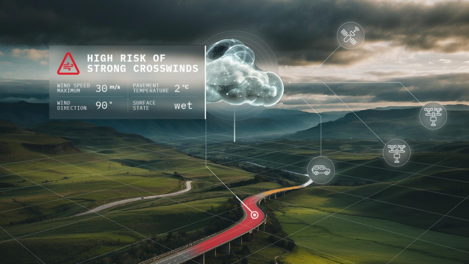
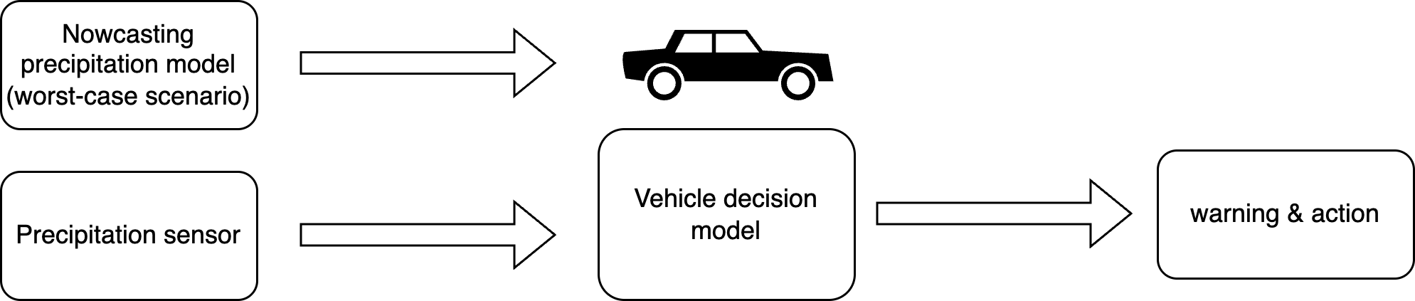
The RoadCast service provides a high resolution, frequently updated weather forecast along specific vehicle routes, delivering critical parameters such as precipitation intensity, wind gusts, hailstorms and road surface conditions. It is designed to support safe operation of advanced driver assistance systems (ADAS) and autonomous functions by giving vehicles foresight into weather hazards beyond the sensor range. Roadcast combines the forecasts from our proprietary AI-models with onboard vehicle sensors and decision units which helps refine real-time detection of weather events, improving accuracy and responsiveness.
The core service includes two data delivery models. First, the pull-based model allows users to request forecast data for a specific route or location. The data is structured by road tiles and route segments, ensuring compatibility with digital map interfaces used in automotive systems. Second, a push-based alert system automatically notifies users—such as fleet operators—when severe weather thresholds are expected in predefined zones.
With this capability, users can make informed decisions about adjusting the performance of the ADAS features by reducing speed and increasing safety distance, or exit autonomous driving modes—improving safety, reducing downtime, and maintaining system reliability in all weather conditions.
Space Added Value
The model training pipeline is the foundational component of our service. It is responsible for generating the predictive capabilities of the system through supervised learning techniques. The input data sources include satellite-based imagery from the Meteosat Second Generation (MSG). This project specifically focused on including Meteosat Third Generation (MTG) instruments, including the Lightning Imager (LI), Infrared Sounder (IRS), and Flexible Combined Imager (FCI).
The new MTG data are better in spatial resolution and quality as well as new spectral bands are added that give insights into very valuable properties of the atmospheric condition. The increase in temporal updates will be very helpful to understand the evolution of storm systems.
Apart from model training, live data from these sources are also used to make the real time forecasts and calculate the derived indicators. Examples of derived indicators include changes in cloud top height, lightning frequency trends, and baseline vertical structure estimations, which are important for detecting convective initiation or intensification.
The forecasting engine runs inference using the most recent data every 30 minutes, with the goal of eventually achieving update cycles as frequent as every 10 minutes. This high forecast frequency will be generally supported by the frequency of the MTG updates.
Current Status
The current status at the final review is -
-
Interacted with 25 industry experts to understand the current status, limitations, and unmet needs related to weather data use in ADAS and autonomous systems.
-
Completed the technical feasibility work for integrating MTG (Meteosat Third Generation) satellite data into our nowcasting model.
-
Filed a patent for a novel method that combines Ventus’s worst-case scenario nowcasting with an onboard vehicle unit.
-
Initial tests of this integrated system show a significant improvement in detecting and forecasting heavy precipitation events with higher accuracy and lead time