
Objectives of the service
Viridien have created an innovative SeaScope service to establish the source of pollution slicks in proximity to assets in response to repeat enquiries from oil and gas operators.
Developed by Viridien’s Satellite Mapping business unit, with support from the European Space Agency, SeaScope provides high-cadence, cost effective, satellite-derived information over offshore assets to establish individual asset baselines and rapidly identify anomalous events. The emphasis of the SeaScope service is on the regular delivery of high-quality, reliable, unbiased information to enhance situational awareness and mitigate environmental risk.
The benefits of using SeaScope as part of routine operations include:
-
Enhanced situational awareness through high-cadence updates
-
Improved response times to potential pollution events
-
Reduced reliance on weather-dependent aircraft-based inspections
-
Minimized health and safety exposure for personnel
-
Cost-effective solution compared to traditional methods
Users and their needs
The core users of SeaScope are offshore oil and gas operators, offshore insurers and environmental regulators within governments. These markets have been fully explored over the past five years in terms of both technical and business development needs.
Key user requirements are consolidated into five broad topics: location of interest, timeliness, quality of deliverables, frequency of deliverables, and confidence of interpretation. User requirements can vary greatly per user and are dependent on the application of the information within individual oil and gas companies, i.e. environment, crisis management and operations. SeaScope is available as a global service and has been developed and demonstrated with a flexible approach, tailored to an individual asset need, so that a wide commercial reach can be achieved.
Service/ system concept
SeaScope is a cutting-edge, multi-mission satellite image analysis service developed by Viridien, designed to provide unparalleled insights into the presence, characteristics, and behaviour of oil slicks in marine and coastal environments. This advanced service leverages a powerful combination of historical and real-time data sources, expert analysis, and sophisticated data management and processing capabilities to support a wide range of applications.
The SeaScope service provides real-time monitoring of oil slicks and other marine pollution events, enabling swift response and mitigation. The service enables historical analysis of oil spill events and trends, providing valuable insights for risk assessment and mitigation. SeaScope also enables customizable reporting and distribution to unlimited distribution lists, supporting a wide range of applications and stakeholders. The service can integrate with other data sources and systems, supporting a comprehensive understanding of oil slicks and their behavior.
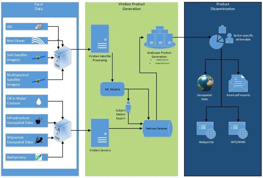
The diagram below outlines the high-level system architecture of the main system.
Space Added Value
SeaScope integrates two space assets: Earth Observation satellites (principally SAR but also Sentinel-2) and satellite AIS data. Satellite imagery is used to observe offshore slicks and Viridien brings world-leading slick interpretation expertise to the SeaScope workflow, enabling the reliable generation of high-quality slick mapping and monitoring intelligence. The combination with satellite AIS data, when utilised, enables the identification of potential pollution sources from local vessel activity.
Current Status
SeaScope follows on from the successful OAPM demonstration project that completed in Jan 2021.The additional changes to the service, developed throughout 2023 and 2024 include two key updated requirements from users: individual asset alerting and improvements to the quantification for slick volumes derived from satellite remote sensing. Additional ML and modelling software have been implemented, as well as a new frontend web portal with improved functionality.
The SeaScope project has successfully demonstrated capabilities in providing improved offshore asset monitoring and oil slick mapping through timely interpretation and delivery of satellite-derived slick mapping data. By leveraging satellite imagery and combining deep interpretative understanding with unique spatial and textural information, SeaScope has provided valuable insights into the interaction between offshore assets, coastal facilities, and the natural marine environment. SeaScope continues to be a fully operational commercial service.