
Objectives of the service
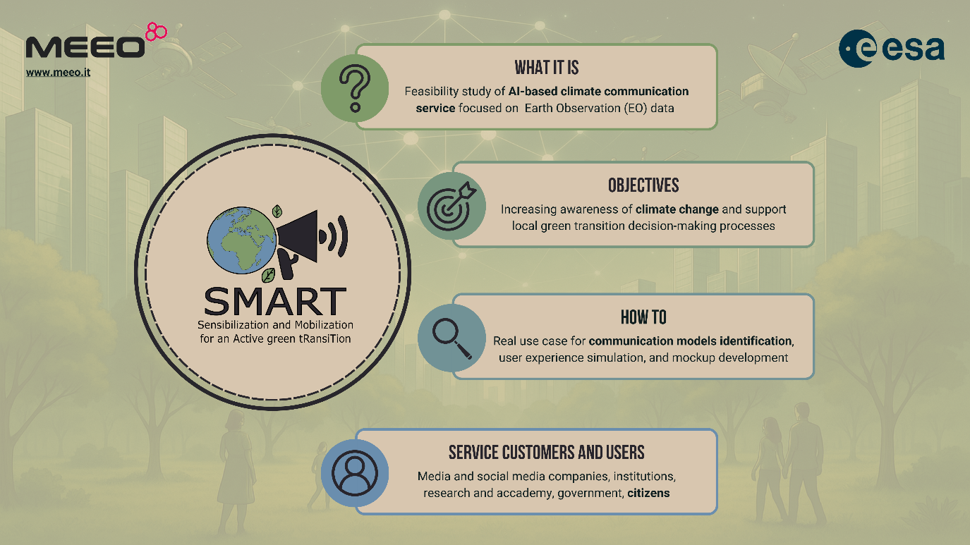
SMART provides the feasibility study of an innovative climate communication AI-based service, with the mockup of the related platform, aimed to support the preparation of scientific multimedia content, personalized, engaging and understandable, by using Earth Observation (EO) data and other knowledge-based information.
The ultimate goals is increasing public awareness of climate change and citizens active participation and contributing to inform decision-making processes by local authorities for green transition plans and policies.
The project idea started from the problem of current limited media content and services, resulting in fewer climate change awareness initiatives. International institutions, scientific entities, and local governments face similar challenges, needing digital services to disseminate climate science. Large amounts of scientific and socio-economic data need to be presented clearly, often through interactive platforms, to raise climate awareness and to emphasize facts over deductions.
The feasibility study was conducted through the analysis of a real use case (2023 flood in the Emilia Romagna Region, in central Italy), by collecting the requirements of different stakeholders and by identifying guidelines for communication template definition.
Users and their needs
SMART targeted and actively involved a diverse range of user communities and stakeholders, including:
-
Research institutions (first, the Geography Section of the University of Bologna's Department of History Cultures and Civilizations, which collaborates as MEEO subcontractor in the project)
-
Media and social media companies (e.g., RAI Italian Radiotelevision, involved in the project from the beginning, and Will Media, Italian digital platform informing on current events through engaging social content, which expressed its interest in SMART).
-
Local governments (notably, the Emilia-Romagna Region, with which the project has aligned platform and communication requirements).
-
International organizations (such as EARCS European Association of Remote Sensing Companies and FAO Food and Agriculture Organization of the United Nations, both of whom have been engaged through project presentations).
These communities share a common challenge: the need to effectively communicate complex climate-related data and actions to varied audiences, expert and not, including the general public and younger generations.
User Needs:
-
Enhanced engagement through interactive and gamified content
-
Improved accessibility for non-expert audiences
-
Personalization based on user interests, context, and knowledge
-
Real-time relevance by linking current events to climate trends
-
Clear, actionable insights to foster individual and collective action
Service/ system concept
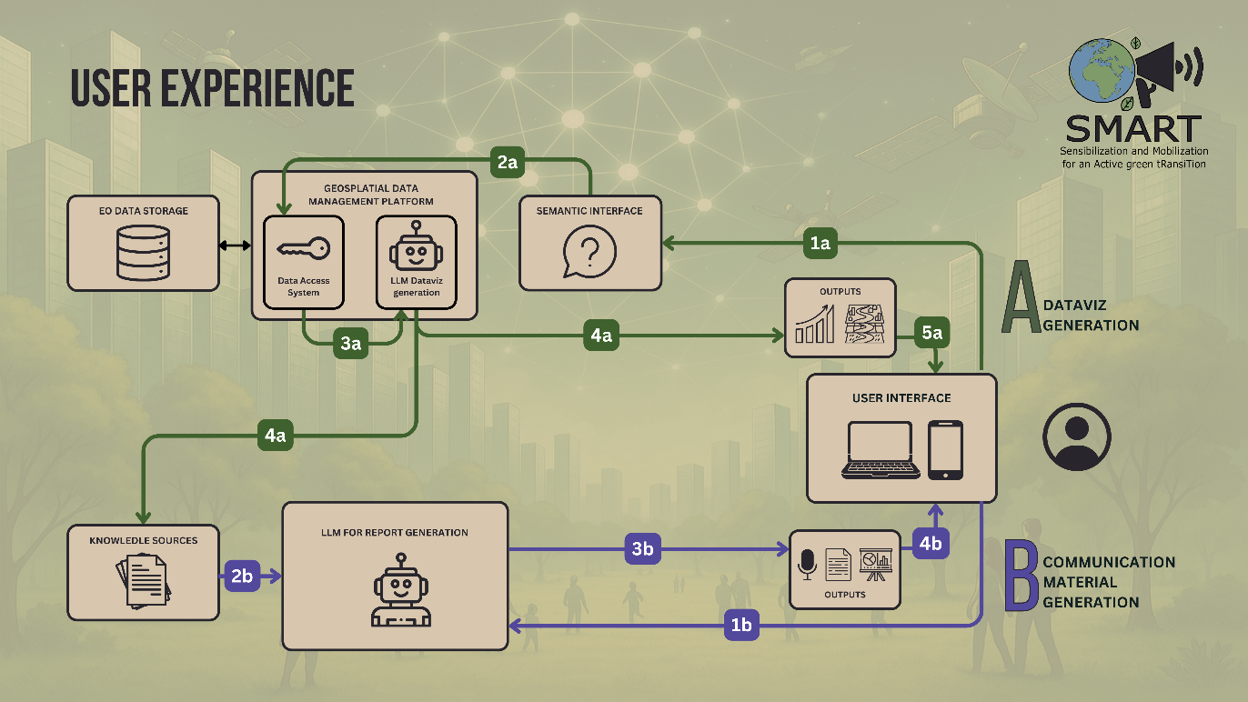
The service includes two types of user interaction, each addressing different needs.
-
Data Visualization Generation
-
Initiation: the user interacts with the semantic interface, submitting a request.
-
Processing: the request is handled by the Geospatial Data Management Platform, which accesses EO (Earth Observation) data through the data access system.
-
Output: an LLM generates visualizations, which are delivered as graphical outputs.
-
Delivery: the visualizations are displayed through the user interface.
-
-
Communication Material Generation
-
Initiation: the user may submit a textual request, or the process may be automatically triggered.
-
Processing: knowledge sources are processed by an LLM dedicated to report generation.
-
Output: the system produces content such as texts, presentations, or audio.
-
Delivery: the materials are presented to the user via the same interface.
-
The two types of interaction address different needs: data visualization generation supports users such as technicians, decision-makers, or urban planners in analysing and understanding geospatial data, providing intuitive visual outputs based on requests made through a semantic interface. In contrast, communication material generation is designed for those focused on outreach and awareness—such as communicators, NGOs, or educators—by transforming data and knowledge sources into accessible aimed at informing and engaging the public.
Space Added Value
The space assets which are used include:
-
satellite imagery and earth observation data collection
-
climate model
-
reanalysis output
-
socio-economic data.
Current Status
The project started at the beginning of November 2024 and closed in May 2025.
The technical and economic feasibility were completed and, considering the interest by the potential key-partners, an implementation roadmap was designed including the following main implementation steps:
POC (Proof of Concept): to provide a sort of MVP (Minimum Valuable Product) that could be opened to key partners;
Service customization: configuration according to specific requirement of key partners;
Demonstration and promotion: functional to service evaluation and adoption.