
Objectives of the service
The service has two objectives:
-
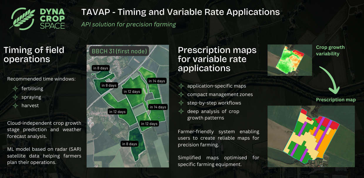
Enable farmers to optimise timing of field operations based on continuous monitoring of crop growth and weather conditions. TAVAP evaluates crop growth stage and weather dynamics using SAR and meteorological data to identify optimal time windows for field operations including seeding, fertilising, plant protection and harvest. Farmers are able to prioritise their actions and plan their operations in advance, mitigating the risks of mistimed operations (low input use efficiency, yield loss).
-
Enable farmers to create reliable precision farming maps for variable rate applications which are adjusted to the specifics of the application (seeding, fertilising or plant protection) and ensure efficient allocation of resources. The growing adoption of variable rate technology puts pressure on the development and optimisation of precision farming technology. TAVAP advances the process of creating prescription maps for variable rate through advanced analysis of crop growth patterns and optimisation of management zones for specific farming equipment and application.
Users and their needs
TAVAP is designed for farmers and farm advisors managing large-scale operations, where timing of fieldwork is a major struggle and the use of digital and precision farming technology is widespread (Europe, North America, Australia).
Field scouting on a large scale is demanding and there is a need for reliable crop data from satellite remote sensing. TAVAP targets this through AI models predicting key growth stages (phenology).
TAVAP system for creating maps for variable rate aims to produce reliable and easy-to-use prescription maps which ensure that the application can be executed as-intended and is cost-effective, i.e. input (fertiliser, seed, spraying agent) use efficiency is maximised. The system enables users to increase yields by increasing rates in zones which can utilise extra input and on the other hand to safely decrease input rates in zones where low input use efficiency is estimated.
The system also finds ways to optimise maps for specific operations and farming equipment as farmers struggle with compatibility issues.
The project involves ADW Agro, a Czech precision farming company, and two farms who will test TAVAP and provide feedback for further development towards commercialisation. A comprehensive field data collection campaign is being conducted together with Mendel University to validate TAVAP using farming logs, soil and plant tissue samples, UAV imagery and harvest data.
Service/ system concept
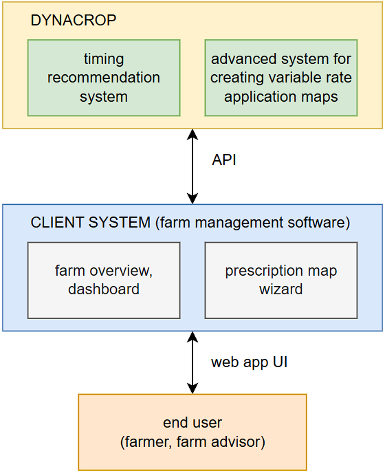
TAVAP introduces two new systems to DynaCrop, an API solution for smart farming which provides satellite crop monitoring and maps for precision agriculture. DynaCrop users monitor crop growth and use variable rate applications to optimise resource allocation (fertiliser, seed). TAVAP integrates satellite, meteorological, DEM and farm data to identify optimal time windows for field operations and to generate maps for variable rate applications. The system is provided as an API and the integrator of the service is a Farm Management Software (FMS).
Timing recommendation system:
-
predicts key crop growth stages
-
evaluates soil and weather conditions
-
identifies optimal time windows for field operations
-
seeding
-
fertilising
-
plant protection
-
harvest
-
-
utilises SAR and meteorological data
-
enables users to parametrise the monitoring system
Advanced system for creating variable rate application maps:
-
identifies crop growth patterns
-
delineates management zones
-
optimises maps for specific farming equipment
-
utilises multispectral imagery and DEM data
Space Added Value
The system utilises Sentinel-1 SAR data for its consistent stream of data even during cloudy conditions, which can be utilised to study crop growth development throughout the whole season. TAVAP incorporates AI models which predict crop growth stages based on the information provided by Sentinel-1 and weather data. The objective of TAVAP is to develop affordable and reliable models providing an alternative to traditional weather-based crop models. These models require a lot of input parameters that are typically not available to most Farm Management Software solutions and therefore can not be used on a large-scale.
Sentinel-2 and PlanetScope multispectral imagery is used to assess crop growth patterns through image analysis of vegetation index data. The advantage of Sentinel-2 is its relatively long archive of data, which currently includes over 8 growing seasons, while PlanetScope provides value to TAVAP through its frequent revisit. Satellite optical imagery is a great source of information about crop growth variability which can be studied over several past seasons and with new seasons being captured every year, the robustness of the solution can only increase.
Current Status
After user and client engagement, the team is currently working on the consolidation of the design. In addition, the pilot activity is being prepared with involved partner farms, ensuring that all needed field data is collected and all involved stakeholders are informed and follow established data collection protocols.
Prime Contractor(s)