

Objectives of the service
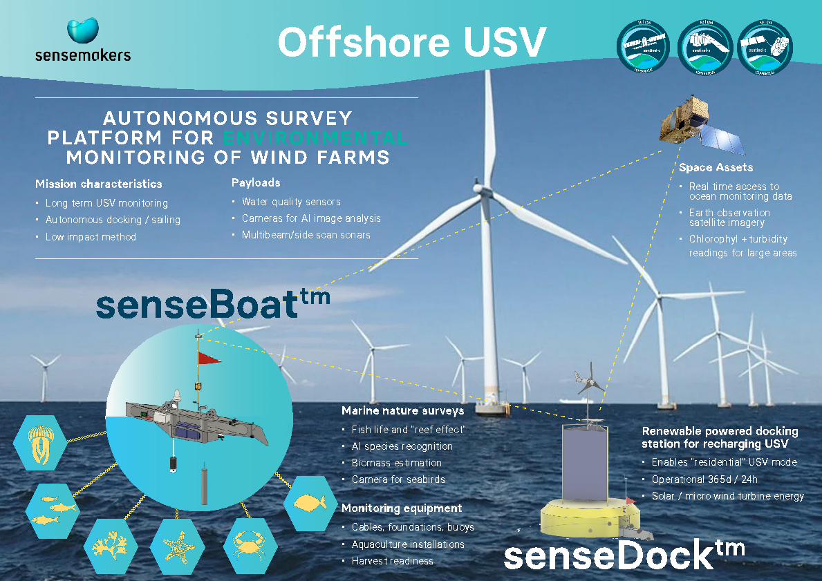
Applying autonomous robotics, AI sensors and satellite technology for maritime use Sensemakers develop a novel approach for monitoring water quality and biodiversity at offshore industries. The mobile surveys provide environmental reporting documentation of the state of fish life, plant life, marine mammals and seabirds in wind farm fields. This includes assessment of the effect from nature-positive initiatives - documenting how offshore industries might create new habitats and support marine biodiversity.
The cornerstone of the service is a SenseBOAT USV deployed in combination with a harbour docking station. The solution allows for continual year long monitoring of the marine environment around wind farms providing unprecedented high resolution in time and space. The unmanned operations of the service with remote operation control and access to data in real-time reduces costs and hassles for personnel to travel to the offshore radically.
As an additional service the low-impact monitoring approach can be tailored to also monitor the state of equipment, aquaculture installations and wind farm assets present in the offshore area.
The KickStart project allows for codesigning the service and technical concept together with major players in the offshore industry.
Users and their needs
The SenseDOCK project is developed in collaboration with two energy companies with field trials in offshore sites.
The aim is to come with a novel approach for automated biodiversity monitoring and conducting environmental surveys around wind farms:
-
Monitoring of fish life and possible reef effects from wind farm structures
-
Monitoring biomass from low trophic aquaculture (seaweed and mussels)
-
Monitoring water quality parameters, nutrients, chlorophyll, etc
-
Automated USV solution that can operate without human operators on-site
-
Hybrid surveys including asset monitoring of turbine foundations, cables, buoys, lines etc.
-
Low environmental impact from monitoring vessels
-
Standardised data formats that can be used directly for environmental reporting
Also, the service is targeted towards engineering consultancies that are specialised in marine surveys and environmental impact assessments for wind farm developments.
Service/ system concept
The SenseBOAT Offshore USV Platform for environmental monitoring provides access to biodiversity and water quality data from wind farms at sea in real-time.
Deploying active acoustics enables thorough scanning for fish life and plants in the entire water column and seabed. This is supplemented by camera-based scanning of fish in the upper parts of the water column analysed using machine learning models. The service will show how wind farms structures can contribute to a possible reef effect providing new habitats for fish life. This including the effects from possible nature-positive installations including artificial reefs and low trophic aquaculture with seaweed and mussel production.
The SenseBOAT USV has a reach to cover large areas of wind farms as well as travelling from shore out and back with water samples. It also enables travelling outside the wind farm area for reference measurements that give a better comprehension of results.
The service includes delivery of ready to go reports that can be used for environmental reporting of biodiversity impact.
An additional service is to deliver marine surveys to use for environmental impact assessments for wind farm developments.
Space Added Value
The SenseBOAT Offshore USV is equipped with on-board satellite connection, that allows for sending monitoring data results in real-time and provide alerts in case of equipment damages. Additionally, the on-board satellite link provides enables a remote operation control centre to take over control of the USV in case of critical situations where human attention may be needed.
An Earth Observation (EO) environmental satellite monitoring model based on Sentinel 1,2 and 3 data provides an increased spatial resolution of chlorophyll levels and water turbidity enabling the overview of larger areas including equipment scanning. The systems work in a dynamic way where the SenseBOAT can ground truth satellite readings.
Space asset provides a ground-breaking method for remotely managing environmental monitoring at offshore sites not possible without the assistance of satellites. Even though there are other companies already using these methods the combination between USV ground truthing and satellite high geographic coverage makes up a unique solution.