
Objectives of the service
Despite the adoption of national guidelines, extraction-site monitoring still faces several unresolved issues that could have damaging consequences:
-
Absence of real-time monitoring – satellite data are collected only once every six months.
-
No predictive estimation of extraction-induced earthquakes – neither induced nor natural events in the areas of interest are forecast.
-
Basic traffic-light approach to decision-making – decisions based on monitoring results rely on a simple red/amber/green system.
-
Slow data analysis and integration – processing is time-consuming and requires numerous experienced professionals from both mining companies and oversight bodies.
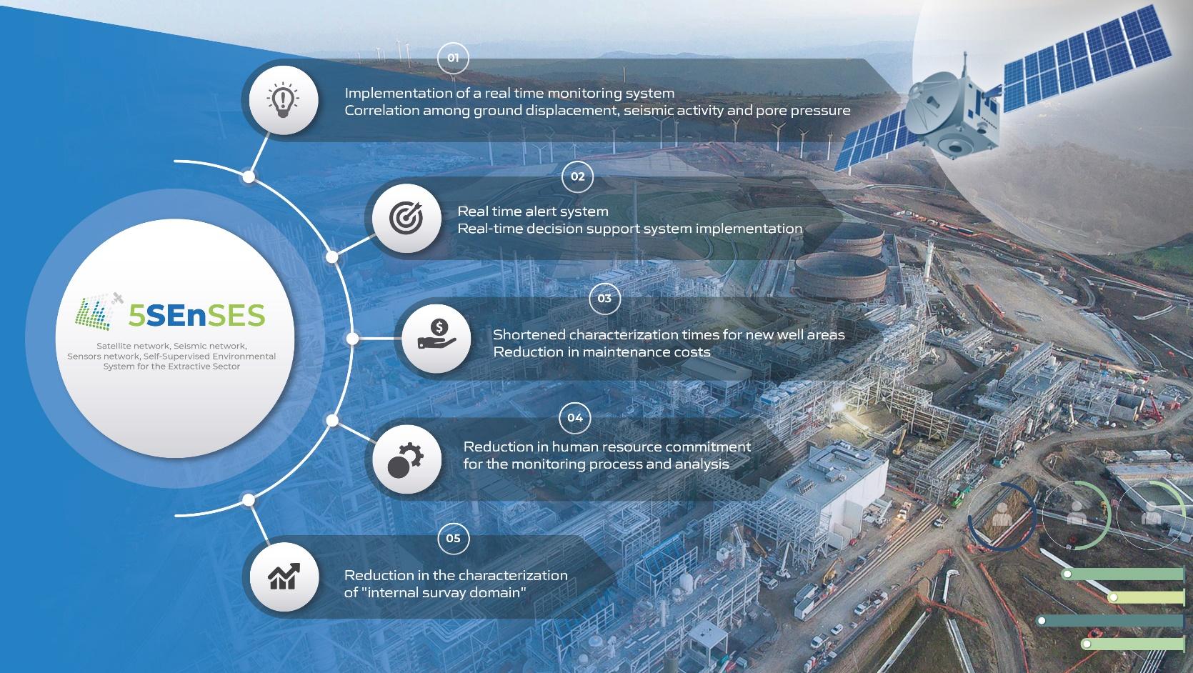
5SEnSES addresses the above shortcomings as follows:
-
Near-real-time monitoring
Continuous ingestion of seismic, satellite (SAR), GPS and IoT data delivers up-to-date situational awareness.
-
Predictive estimation of extraction-induced earthquakes
Artificial Intelligence models provide forecasts for extraction-induced events within each site of interest.
-
Integrated multi-network analytics
Correlation of seismic, satellite and ground-based datasets drastically reduces false alarms and supplies site-specific risk assessments.
-
Area-optimised decision-support system
A dynamic, interactive dashboard consolidates real-time seismic, ground-deformation and pore-pressure data, automatically generates correlation and risk-analysis matrices (Continuous Effectiveness Measurement Model), issues anomaly alerts and provides full historical logs—delivering site-specific guidance while reducing the need for human resources.
Users and their needs
5SEnSES currently targets three clearly defined user segments and their needs:
Private and state-owned industrial operators - oil and gas, geothermal and mining companies
-
Near-real-time, site-specific monitoring and reporting that merge seismic, SAR, GPS and IoT feeds
-
Automated anomaly alerts and decision support
-
Predictive modelling to plan operational changes and reduce downtime
-
Streamlined characterisation of survey domains
-
Demonstrable compliance with Italian MISE guidelines and comparable EU regulations
Public regulators and infrastructure authorities
-
Verifiable audit trails and full historical logs
-
Anomaly alerts that streamline permit decisions and emergency response
-
Evidence-based verification of reduced environmental impact, leaks and induced seismicity
Research institutions (universities and seismic labs)
-
Harmonised multi-source datasets for earthquake-risk studies
-
High-resolution ground-motion and pore-pressure series for model validation
-
Open API access enabling bespoke analytics without costly field campaigns
The pilot was implemented with TotalEnergies, and 5SEnSES already operates at six of the company’s wells in Basilicata. The platform has also been adopted by the Istituto Nazionale di Geofisica e Vulcanologia (INGV) for joint research with the Berkeley Seismological Laboratory, further validating its scientific value.
Service/ system concept
Through 5SEnSES, users access a dynamic dashboard that combines real-time data streams with an extensive historical archive. The key information attributes and their characteristics are as follows:
-
Seismic activity – seismic activity in the area of interest, as defined by MIMIT - Ministero delle Imprese e del Made in Italy (ex MISE) guidelines.
-
Ground deformation – interactive 3D maps showing ground displacement, in millimetres over time, derived from satellite data processing.
-
Pore-pressure parameter values – the dashboard furnishes users with current pore-pressure parameters.
-
Correlation indices – calculated and displayed, providing a key analytical tool.
-
Maximum-possible-magnitude earthquake probability map – provides site-specific data
-
Seismic-activity anomaly alerts – generated whenever seismic readings deviate from historical baselines.
-
Ground-deformation anomaly alerts – issued when anomalies are detected in ground deformation compared to historical values.
-
Correlation-parameter anomaly alerts – triggered when correlation parameters among seismicity, ground deformation and pore pressure fall outside normal ranges.
-
Risk-analysis matrix implementing the Continuous Measurement of Effectiveness Model
-
Historical data – a complete record of every information layer, enabling in-depth analysis and comparison.
The following figure shows the functional high-level architecture.
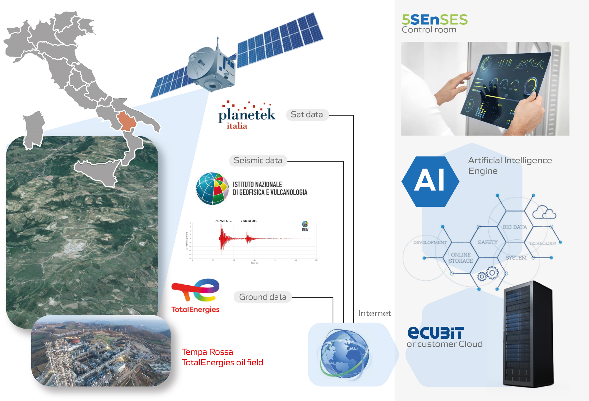
Space Added Value
5SEnSES exploits satellite Earth-observation and satellite-navigation assets—specifically SAR imagery and GPS data—to deliver accurate, reliable measurements of ground movement. By combining these space-based datasets with seismic waveforms and applying cutting-edge machine-learning algorithms, the platform provides quantitative assessments of seismic activity and mitigation processes. Advanced scripts enable fully autonomous monitoring of faults and landslides, and detect surface effects of tectonic processes directly from satellite data. Seismometer readings are also utilised to obtain detailed information on earthquakes, whether naturally occurring or induced by human activity.
Although several firms supply stand-alone monitoring systems, market demand is shifting towards integrated, intelligent solutions. 5SEnSES adds value by correlating near-real-time satellite observations with terrestrial data, revealing the relationship between seismic activity, ground deformation and well pore pressure - a parameter directly linked to well productivity and risk analysis.
Current Status
The project started on 23 September 2023, and was completed on 23 July 2025.
Prime Contractor(s)