
Objectives of the service

The project proposes a new service designed to establish and operate the Space Data Information Centre (SDIC) in Nairobi (KE) to foster the utilization of space data, expertise and knowledge to catalyze commercial services in multiple sectors and generate revenues strengthening the SPARKme service offering. The SDIC will serve as an information centre providing data, products, insights, and training based on EO and space technologies to support industries, government, and academia in Kenya and other African Countries.
The proposal will pursue the following objectives:
-
Establish a fully operational data centre for space-related data processing and analysis.
-
Utilize trained human resources effectively to generate valuable insights for multiple domains based on user needs.
-
Develop a sustainable business model through data sales and training programmes using real data.
-
Strengthen global partnerships to enhance expertise and market reach.
-
Expand the centre’s capabilities over time to include additional value-added services.
To support this initiative, the service will provide professional technical training in EO and space technologies for Kenyan students and public officers.
Users and their needs
The services are addressed to both university graduate students and public officers working and living in Kenya (Nairobi area). They are facing the following challenges:
-
While Earth Observation (EO) data is readily available, many African industries, governments, and institutions lack the infrastructure, technical capacity, or awareness to fully utilize this data. The SDIC will act as a central hub to process, analyse, and transform EO data into actionable insights tailored to local needs.
-
Although Africa has skilled professionals in EO and geospatial sciences, many rely on external data processing centres and expertise located outside the continent. The SDIC will develop localized processing capabilities, ensuring that African institutions and businesses retain control over their data and insights.
-
While Africa has EO specialists, there is a growing demand for expertise in advanced space technologies, including IoT, sensors, GNSS, satellite communications and drones. The SDIC’s training programme will go beyond traditional EO applications by integrating these technologies into a multidisciplinary curriculum.
-
EO applications in Africa remain underutilized in commercial markets. The SDIC will be instrumental to establish a sustainable business model by monetizing EO data services through customized analytics, decision-support tools, and training programs for industries such as agriculture, climate monitoring, disaster management, and urban planning.
Service/ system concept
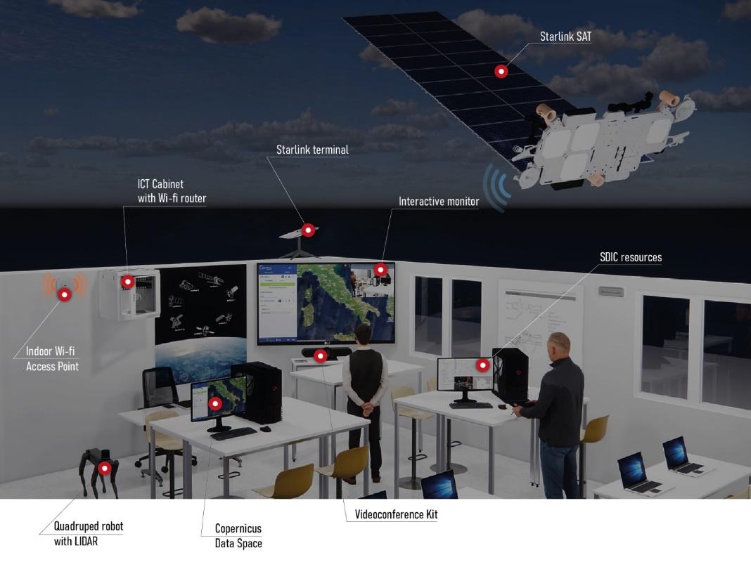
The SDIC will serve as an information centre providing data, products, insights, and training based on EO and space technologies. Key components are:
-
EO and satellite datasets: customized datasets and analytical reports for decision-making and commercial service applications.
-
Training and Capacity Building: professionalising training in EO and geospatial analytics, drones, and satellite communication, including certifications.
-
Consulting and Insights: risk assessments and technology access and innovation support.
-
Partnerships and Commercialization Support: facilitating collaborations for commercial opportunities.
During the pilot stage, end users will have access to:
-
EO Data ecosystem providing an integrated suite of satellite data, software tools, and cloud-based resources; offering free and open access to Sentinel satellite imagery. The platform includes cloud infrastructure for efficient data access, storage, and on-demand processing, enabling users to analyze large datasets.
-
Interactive virtual labs: trainees can engage in hands-on practice through virtual labs, simulating near real-world scenarios and equipment operations, thus enhancing practical skills without geographical limitations; moreover, trainees can enable (near) real-time monitoring, interaction, and feedback with trainers.
-
Integrated Visualization Platform (IVP): a web-based solution designed for the management and monitoring of robotic devices, IoT and Satellite data analysis integrated on a Digital Twin.

Space Added Value
The SDIC leverages multiple space assets, primarily Earth Observation (EO) satellites , GNSS for geolocation, and satellite communications to enable remote access and data delivery. These assets are integrated with emerging technologies such as IoT sensors and drones to create a comprehensive space-enabled service offering.
The added value of combining these space assets lies in their ability to deliver timely, scalable, and location-specific insights that surpass the limitations of conventional ground-based methods. Unlike existing competitors who may rely on manual surveys or fragmented data sources, the SDIC provides real-time, high-resolution, and wide-area coverage, enabling more accurate monitoring of agriculture, environment, urban development, and disaster risks. Additionally, localized data processing and user-focused analytics at the SDIC eliminate reliance on foreign services, reducing costs and latency. This integrated space-based approach empowers local decision-makers, supports commercial innovation, and fosters sustainable development through actionable intelligence.
Current Status
The CCN1 to the SPARKme project has been kicked off on 10th of June 2025. The official presentation of the project activities to the project partners has been realised and their contributions remarked. Preparatory activities aiming to get feedback about effective user needs and start the recruitment of beneficiaries have been launched. The Baseline Design Review is planned on the 21st of July 2025.