Objectives of the service
The Coastal Ecosystems – MRV service provides monitoring, reporting and verification of conservation and restoration of coastal ecosystems such as mangroves and saltmarshes. Despite the importance of these ecosystems, there is increasing pressure from aquaculture, tourism and infrastructure, with existing threats and new stressors from land-based pollution, extractive sectors and climate change. Government and philanthropic funds are insufficient to meet the funding needed for restoration and conservation, leading to an urgent need for private funding. Developing high-integrity natural capital markets creates an opportunity to protect and preserve these vital ecosystems. Currently several challenges exist for the creation of such markets, more so for marine or blue natural capital markets – where several knowledge and data gaps exist, these include establishing baselines, ensuring additionality and addressing evidence gaps. The service seeks to facilitate the development and growth of functional high-integrity natural capital markets by filling several of these knowledge and data gaps in the market. The objective of this activity is to use satellite earth observation data to determine habitat characteristics and environmental factors and meet the requirements for issuance of carbon and biodiversity credits, objectively and cost-effectively.
Users and their needs
The service is targeted towards project developers, impact advisory firms, conservation organisations, sustainable finance advisories and other stakeholders that play key roles in the development, sale, investment and purchase of carbon and biodiversity credits through restoration and conservation of coastal ecosystems. The service will allow users and customers to better monitor projects, while fulfilling reporting and verification requirements easily, objectively and cost-effectively. Deploying these enabling technologies as part of the growing blue natural capital markets will help increase confidence in these nascent markets, through greater credibility and integrity, while augmenting scientific expertise and technical capacity, helping reduce both financial and technical barriers to entry. The user needs can be summarised as follows:
-
Map coastal ecosystem extents for effective site selection and project implementation
-
Evaluate habitat conditions, such as degradation and above-ground biomass
-
Measure efficacy of conservation and restoration efforts
-
Evaluate historic baselines, climate risk and anthropogenic impacts
-
Building investor confidence and create awareness
-
Use scientifically sound and standardised approaches for data collection and reporting
-
Evaluate ecosystem co-benefits and value
Potential users and customers for the service are being targeted in the United Kingdom and Tanzania.
Service/ system concept
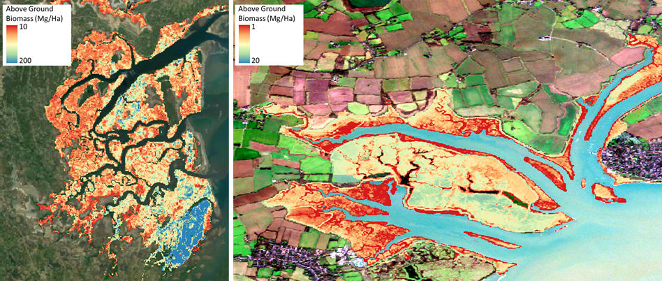
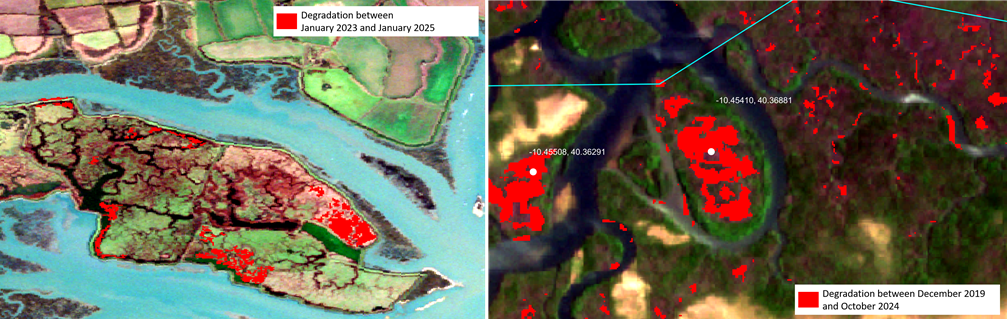
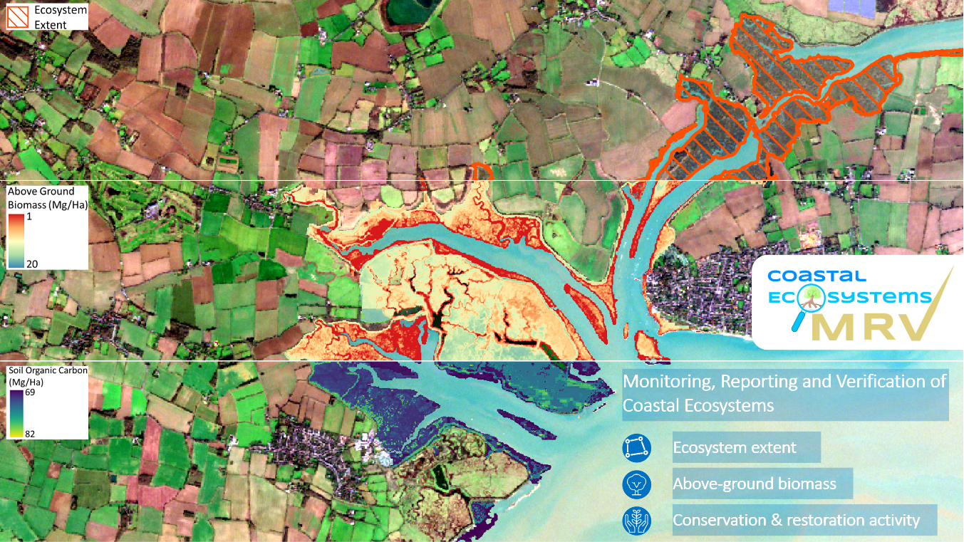
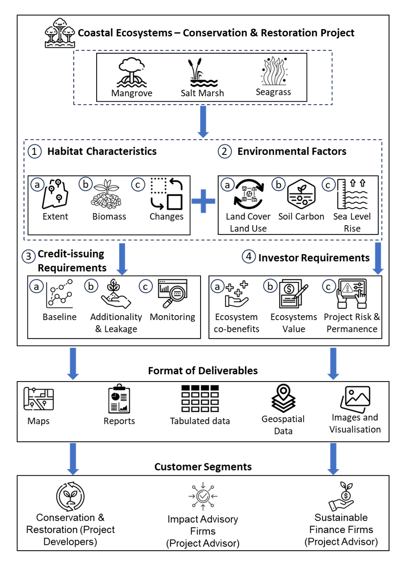
The Coastal Ecosystems – MRV service uses SatEO data, geospatial analytics and machine learning algorithms, to map habitat characteristics such as ecosystem extent, above-ground biomass and ecosystems changes over time. Environmental factors such as land cover – land use, soil organic carbon, sea-level rise etc., are also evaluated over the project area and selected reference areas, these indicate drivers of change and risk posed to project implementation and to the durability and permanence of credits. Evaluating habitat characteristics and environmental factors, serves as a precursor to meeting credit-issuing requirements for carbon and biodiversity credits such as determining baselines, measuring additionality and leakages, and monitoring project activity. Helping meet investor requirements such as determining ecosystem value, project and permanence risks, and ecosystem co-benefits, can provide a more complete service with a higher value proposition. The service deliverables are in the form of maps, reports, tabulated data (e.g. degradation rates), geospatial data (e.g. shapefiles, geotiffs), images and visualizations.
Space Added Value
Satellite Earth Observation (SatEO) plays an important role in the development and deployment of the Coastal Ecosystems – MRV service. It is an essential data source used in classifying the spatial extent of coastal ecosystems and evaluating key bio-physical characteristics such as above-ground biomass. It is vital for determining location, extent and magnitude of carbon sequestration and biodiversity net gain services provided by the ecosystems. The spatial resolution, temporal coverage and global reach provided by SatEO is unmatched when compared to in-situ or field measurements. Its availability and data quality allows deployment of the service on a global scale, a significant improvement over field or drone data collection, both of which can be costly, sparse and irregular.
Various types of SatEO data allow analyses to be conducted in varying environmental conditions, L-band radar allows mapping of mangroves in tropical belts that experience persistent cloud-cover. Similarly, multi-spectral data and digital elevation models (DEM) allows mapping of saltmarshes. SatEO data used includes multi-spectral data from Sentinel – 2 acquired via Copernicus Data Space, radar data from ALOS PALSAR acquired via JAXA’s Earthgraphy web-portal, SRTM DEM data acquired via USGS Earth Explorer and land cover-land use data from ESA World Cover.
Current Status
The kickstart activity was completed in April 2025.
Through the activity the company engaged with over a dozen users, constituting project developers and advisors, working on conservation and restoration projects of coastal ecosystems. The efficacy of the service was demonstrated through analyses and proof-of-concept pilots with four potential customers. Two partnerships were established with these potential customers keen to engage in commercial projects.
The service was presented at Ocean Risk and Resilience Alliance’s Investor Forum in London, where the service was pitched to over twenty stakeholders, potential customers and investors.
Achieved significant progress in service development, with further refinement to be achieved through user validation and feedback, and further project implementation. Feedback and validation from users is being sought for pilots implemented during the course of the activity.