
Objectives of the service
The agricultural sector is undergoing significant transformation, driven by the imperative to enhance productivity, sustainability, and address labour shortages. Agricultural robotics (agbots) are at the forefront of this revolution, promising to automate a wide range of field operations, from precision seeding and spraying to harvesting and mowing.
The primary objective of this Kickstart activity was to assess the technical feasibility of leveraging advanced GNSS capabilities, specifically its integrity features, integrated within a cost-effective sensor fusion architecture to deliver a geofencing safety system for agbots.
This system targets a high level of robustness and safety integrity, aiming for AgPL-c (Agricultural Performance Level c), corresponding to a Probability of Dangerous Failure per Hour (PFHd) of < 10⁻⁶/hr. The focus was on achieving superior robustness and trustworthiness of the positioning solution, especially under challenging conditions, rather than solely maximizing absolute accuracy, although sufficient accuracy for the geofencing task is naturally required.
Users and their needs
The end users are the actual operator of agbots and autonomous machinery and fall into several overlapping roles, each with distinct perspectives on safety, usability and reliability:
-
Farmers: Own and manage the land and equipment, expect reliable automation to reduce labour and improve efficiency
-
Contractors: Operate machinery across multiple farms and requires consistent performance across varying conditions.
-
Operators: Handle the day-to-day operation, maintenance and interventions, need intuitive solutions with clear diagnostics
-
Supervisors: Oversee fleet behaviour and safety compliance, require high-level assurance metrics, traceability and alerting systems.
The users of this solution will primarily be in Europe and have also relevance elsewhere in the world.
The user needs include safe boundary adherence, high uptime, improved ROI, acceptable residual risk and safety analyses targeting AgPL-c.
Lost GNSS signal for autonomous field robots is subject for frustration for most OEMs end-users. The vehicle will stop its operation when the signal is lost or degraded and hence becomes inefficient and not the helping tool as expected. If the GNSS signal is lost or inaccurate, a potential loss in yield of production will be a potential direct consequence. When the agbot stops due to degraded GNSS signal, it requires a user/operator to actively resume the operation each time, so the fewer stops, the lesser frustrations at the users end.
Service/ system concept
The capabilities the users will have when the service is deployed are:
-
Maintain reliable position error bounds even in environments where primary positioning sources are degraded.
-
Ensure the system meets a stringent target integrity risk threshold.
-
Detect and respond to proximity-based safety events relative to predefined operational boundaries.
-
Detect and handle localization system failures to maintain operational safety.
-
Provide resilience against intentional signal manipulation through authentication techniques.
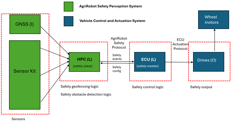
The GEOFENCE Integrity Service provides a continuously monitored, high-integrity position and its associated uncertainty for an agbot. This information is used to:
-
Dynamically assess the agbot's proximity to predefined geofence boundaries.
-
Trigger appropriate safety actions if the risk of boundary violation becomes unacceptable based on the current integrity level and vehicle state.
-
Enhance operational availability by allowing continued operation in GNSS-degraded areas where traditional systems might halt.
-
Generate alerts upon detection of positioning signal anomalies or critical system failures.
Space Added Value
GNSS is a strategic component in agriculture and more and more of the agricultural data is getting stored in GIS farm management systems. Application maps, yield maps, soil maps etc. are becoming more and more critical and the farmer needs GNSS in all locations of his fields to use these tools efficiently. Other localization sensors will struggle in the open field if there are no good structures to use, so here the GNSS is for sure the most suitable and affordable sensor technology for localization for precision farming as well as auto-steering and robot navigation.
Current Status
The Geofence Kickstart feasibility study has been completed in May 2025 with good results regarding both the technical and the commercial perspectives. The involved customers have all expressed continuous interest in what will become the final product. It can solve a lot of current issues they face in daily operations. That position also provides a strong foundation to continue finalising the GEOFENCE solution.
Prime Contractor(s)
