Objectives of the service
The GeoFusion service addresses key challenges faced by agricultural stakeholders, policymakers, and sustainability-focused businesses. These include inefficient data accuracy for agricultural compliance monitoring, insufficient transparency in subsidy allocation, and limited tools for quantifying and securitizing natural capital assets like biodiversity and soil health or ecosystem status.
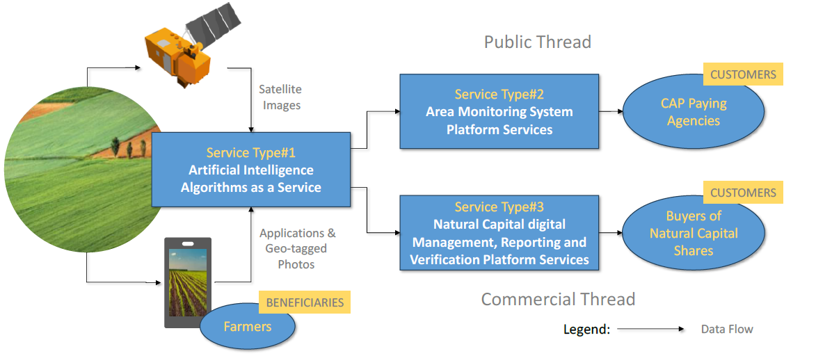
The solution combines satellite data, Geotagged Photos, advanced AI-supported analytics, cloud processing solutions to deliver a scalable and integrated monitoring system. By utilizing Earth Observation assets, such as Copernicus Sentinel satellites, alongside soil and biodiversity data, GeoFusion enables precise tracking of agricultural practices, subsidy compliance, and environmental impact. This system reduces administrative burdens, improves transparency in area based direct payment management and provides actionable insights for landowners, policymakers, and business enterprises.
The project’s objectives are to design, develop, and validate a prototype service that streamlines compliance monitoring while unlocking new revenue streams through Natural Capital Shares. By combining cutting-edge space technology with innovative methodologies, GeoFusion delivers value-added services that promote sustainability, reduce inefficiencies, and support environmental and economic goals.
Users and their needs
Targeted User Communities
The GeoFusion service is aimed at diverse user communities across Europe, including:
-
Government Authorities: Needing accurate and efficient agricultural subsidy monitoring and natural capital accounting to align with EU policies like the Common Agricultural Policy (CAP).
-
Farmers/Landowners & Food Industry: Seeking tools to simplify subsidy compliance and monetize their ecosystem services (e.g., biodiversity credits, soil health metrics).
-
Corporate Sustainability Teams and Investors: Looking to integrate natural capital metrics into ESG reporting, carbon insetting, and biodiversity offsetting strategies.
User Needs
-
Streamlined compliance processes with reduced administrative burdens.
-
Transparent, reliable, and scalable tools for measuring and tracking ecosystem services (flows) and natural capital (stock).
-
Decision-making support based on accurate and actionable data.
Challenges
-
Ensuring data interoperability across diverse sources (e.g., satellite, soil maps, field inputs).
-
Balancing usability with the complexity of data-driven insights for non-technical users.
-
Demonstrating tangible pilot sites for all stakeholders.
The service primarily targets European Union countries with significant CAP-related subsidies, such as Austria, Baltics, Germany, France, and Spain.
Service/ system concept
GeoFusion leverages Earth Observation (EO) data, specifically from Copernicus Sentinel-1 and -2, to provide reliable, accurate, and actionable information for agricultural monitoring and natural capital management. The service integrates Geo-Tagged Photos, multispectral and radar data with advanced AI models to address key user needs:
-
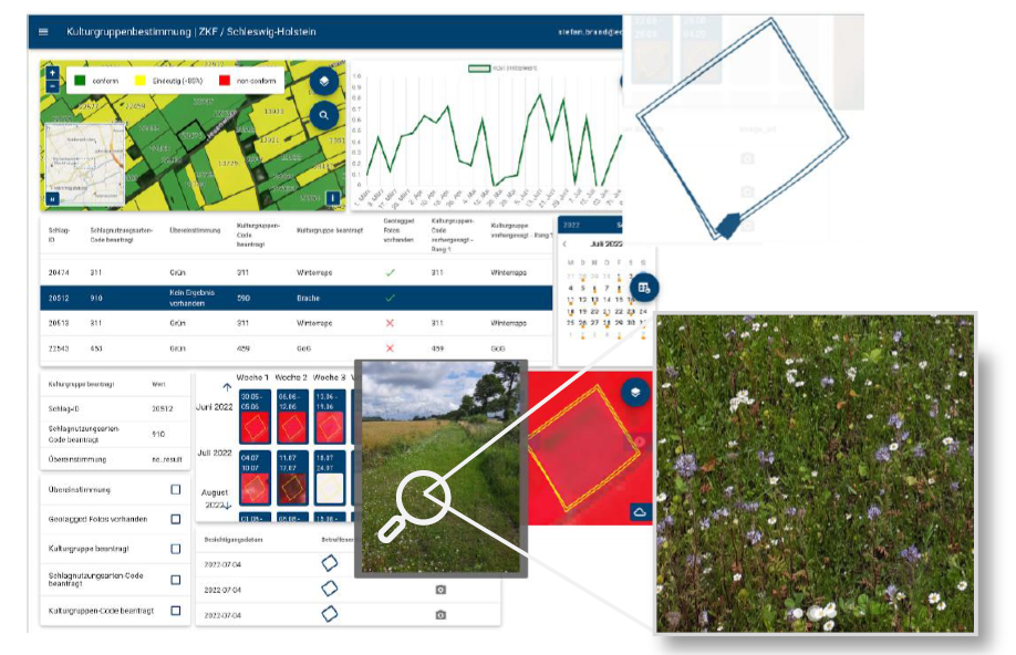
For CAP Paying Agencies: Automated detection of Good Agriculture and Environmental Conditions (GAECs) and eligibility conditions (ElCos) for subsidy compliance as part of the Area Monitoring System (AMS) is reducing non-conclusive observations and on-screen photo interpretation interventions. This includes parcel-level monitoring of crop types, mowing and harvest events, biodiversity and climate related activities.
-
For Buyers and Sellers of Natural Capital Shares: A digital MRV (Monitoring, Reporting, and Validation) solution that ensures scientific soundness, transparency, scalability and cost-efficiency. High-resolution EO data strengthens trust through detailed and credible GIS/WebGUI insights for investors.
-
Innovative AI Integration: Synergic use of radar (Sentinel-1) and optical (Sentinel-2) Copernicus data improves reliability during cloudy conditions, creating a robust, year-round monitoring solution.
The added value lies in enhanced operational efficiency, reduced costs, and strengthened decision-making processes, with a focus on enabling financial transactions like CAP subsidy payments and ecosystem service monetization, while maintaining high levels of accuracy, scalability, and trustworthiness.
Space Added Value
The GeoFusion project integrates advanced space assets, including Copernicus Sentinel satellite data (Sentinel-1, Sentinel-2) and other Earth Observation systems, to enhance Agricultural Monitoring Systems (AMS) and Natural Capital Share (NCS) solutions. Sentinel-1’s radar capabilities ensure reliable all-weather monitoring, while Sentinel-2 provides high-resolution optical data for vegetation analysis and crop health assessment. These datasets enable precise and scalable agricultural and environmental monitoring. Automated fusion method of Geo-tagged photos leads to better training and validation of the developed models.
By leveraging the Copernicus ecosystem, the project ensures interoperability and expands existing AMS capabilities, addressing gaps such as localized soil health assessments and biodiversity indicators. Integrating space-based data with ground-based inputs (e.g., GTPs, IoT sensors, farmer inputs) creates comprehensive datasets, allowing for more precise compliance checks, improved event markers, and the development of actionable biodiversity and carbon credits.
The added value lies in the scalability, accuracy, and cost-efficiency that space assets provide compared to traditional methods. Unlike competitors relying solely on local datasets or manual sampling, the use of satellite data enables consistent, real-time monitoring across large areas. This approach reduces administrative burdens, enhances decision-making for policymakers and businesses, and fosters innovation in sustainability markets like biodiversity and carbon trading—securing a competitive edge while driving environmental impact.
A dedicated development and deployment instance has been provided for demonstration and discussion with stakeholders, developing the Natural Capital Solutions Platform, extending the functionalities with the GTP visualization.
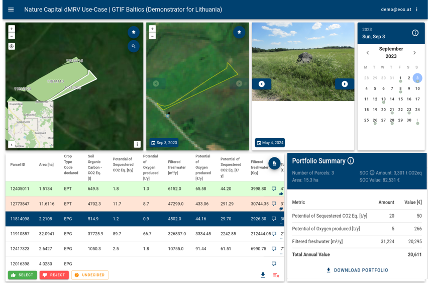
GeoFusion Natural Capital Solutions Seller Analytics & Portfolio Selection Dashboard (Demonstrator) - visualizing parcels available for support/investment on a Lithuanian pilot site, with the integration of IACS data and showing example ecosystem services indicators and potential financial impact (EUR-values).
Current Status
Current activities cover:
Designing the downstream workflow following image segmentation: This includes defining the process for selecting the Area of Interest (AOI) within segmented images and applying a classification model exclusively to the relevant features.
Stakeholder Alignment: Engaged key contributors to refine the project outline and clarify milestone activities, roles, and timelines. Requirement Definition: Differentiated User Requirements (WHAT) from System Requirements (HOW) to ensure a logical flow from user needs to actionable solutions - applying a customer-centric approach to Buyer Market & Customer Development.
dMRV Development: Selection of relevant data for in-situ Carbon Organic (Corg) / Soil Organic Carbon (SOC) evaluation, and development of the Biodiversity & Carbon Farming Index Methodology — supporting the assessment of ecosystem connectivity and the uplift potential of arable and grassland systems. This underpins the issuance of biodiversity or nature credits, for example in the context of High Nature Value Grassland and arable land practices such as Conservation Agriculture.
Deriving Indicator and financial impact values on parcel level related to:
-
Organic carbon stock & CO2 sequestration potential and oxygen production,
-
Fresh water filtration capacity against N-leakage,
-
Biodiversity: habitat connectivity and agro-diversity as species richness and from rotational effects,
-
IACS-verified ecological and regenerative parcel management practices.
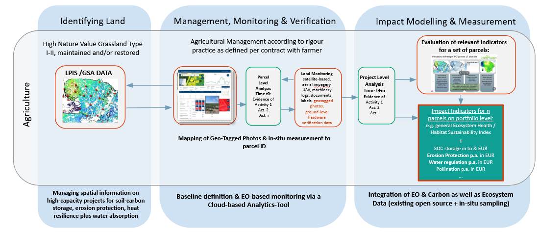
GeoFusion NCS-Methodology for digital Measurement, Reporting, Verification and Impact of agricultural Ecosystem Services
Prime Contractor(s)