
Objectives of the service
The INST project has demonstrated a system for managing mass casualty incidents (MCIs) through digital representation of casualty location, condition, and priority. The Site Acceptance Test (SAT) milestone validated core system functionality under controlled conditions, including secure data transmission across a multi-bearer communication architecture incorporating satellite-enabled capability.
The system supports tri-service responders – Police, Ambulance, and Fire and Rescue – by providing improved situational awareness and enabling more effective command and coordination during incident response. These capabilities were subsequently demonstrated in a pilot environment, confirming operational relevance and supporting progression towards deployment readiness.
Users and their needs
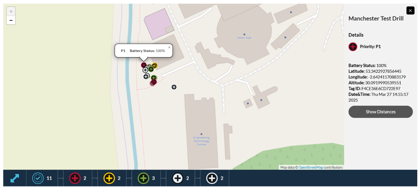
The INST project engaged emergency service stakeholders through structured demonstration activities, including the Site Acceptance Test (SAT) at STFC Daresbury and a subsequent pilot demonstration at the Manchester Velodrome in March 2026.
During these activities, observers were able to see the system operating in a representative scenario, including real-time tag visibility, indoor positioning, and digital twin-based incident mapping. Feedback indicated alignment with the operational need for improved situational awareness, clearer triage coordination, and structured information flow during high-pressure major incidents.
Stakeholders highlighted INST’s relevance for both terrorism-related and large-scale civilian events, supporting multi-agency interoperability in line with JESIP principles and emerging Martyn’s Law requirements. NHS and Local Resilience Forum representatives identified value in establishing a shared operational picture early in an incident, enabling faster prioritisation of casualties and responder activity.
The pilot demonstration provided qualitative validation of system usability and operational relevance, indicating that the concept addresses a recognised gap in current emergency response capability.
Service/ system concept
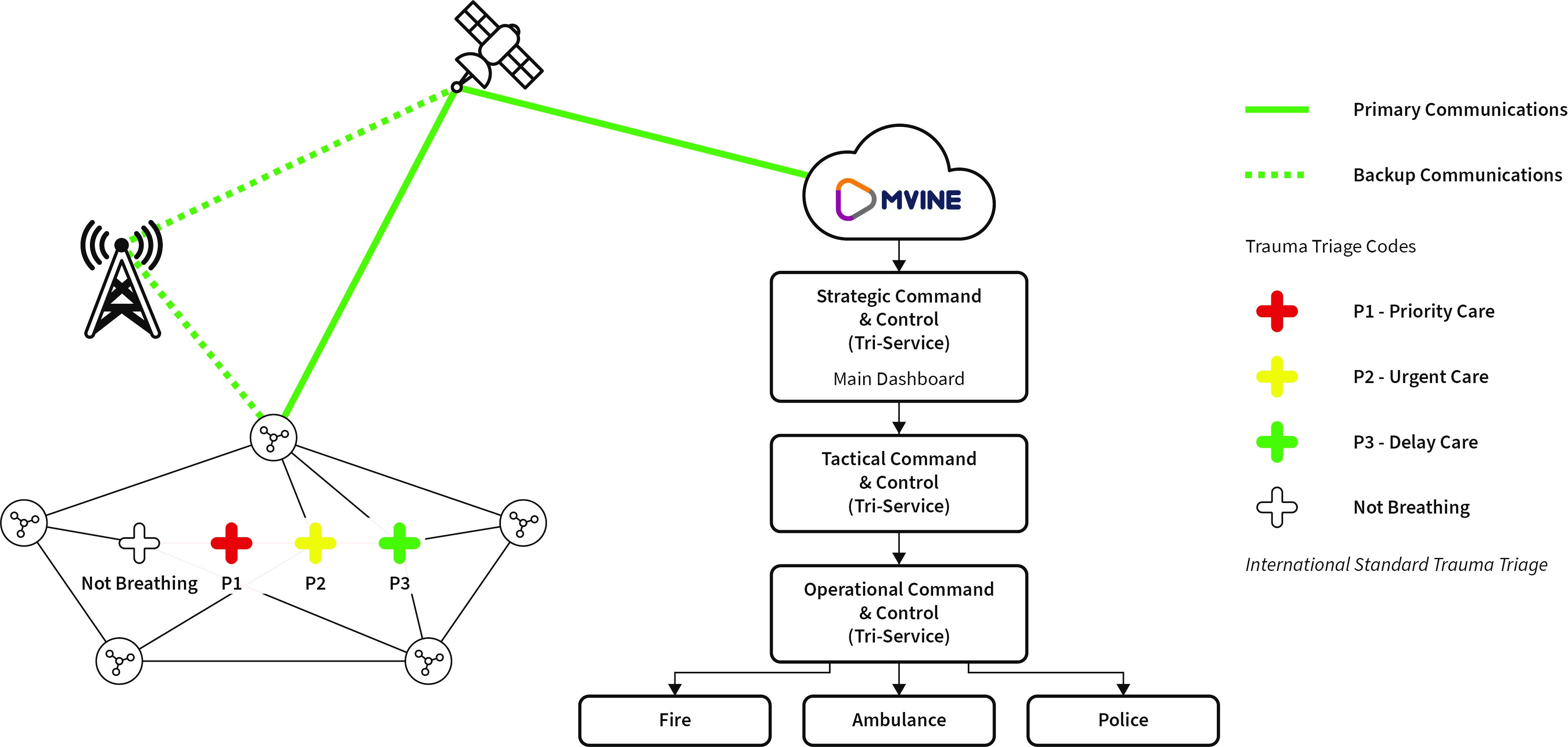
The INST service integrates lightweight smart triage tags, ad-hoc mesh gateways, and a cloud-connected digital twin dashboard. During SAT, data was transmitted seamlessly between tags, gateways, and the Mvine Digital Twin dashboard using cellular, LoRa, and satellite links.
The system demonstrated reliable end-to-end communication, positional accuracy within 2 m, and data latency under 3 seconds. These results confirm readiness for pilot deployment in operational environments.
The digital twin interface enabled real-time visualisation of casualty locations, triage states, and responder movements. Satellite fallback-maintained communication when terrestrial networks were intentionally degraded during testing, validating robustness in high-stress emergency conditions.
Space Added Value
The SAT evidence phase has demonstrated the added value of space-enabled communications resilience within the INST concept. While the SAT scope focused on indoor positioning and core service functionality, the system architecture has been validated to support satellite-enabled communication as part of a multi-bearer approach.
In major incident environments, terrestrial networks may become congested, unavailable, or unreliable due to infrastructure failure, remote locations, or deliberate disruption. Satellite connectivity provides an alternative communication pathway to support continuity of situational awareness and the transmission of triage and location data when ground-based coverage is limited.
INST therefore represents a practical ESA-supported demonstration of how hybrid terrestrial and space-based communications can strengthen emergency response capability. Satellite-enabled resilience remains a core component of the architecture, with further validation of operational satellite integration identified as a follow-on activity beyond the SAT baseline.
Current Status
The project has been completed and the Final Review has been held in April 2026.
The INST project has completed the pilot demonstration at the Manchester Velodrome. The pilot demonstration provided qualitative validation of system usability and operational relevance. Stakeholders were able to observe real-time visibility of casualty status and location, demonstrating the system’s ability to support shared situational awareness across responding agencies.
All validation and demonstration evidence has been consolidated within the Final Data Package (FDP), ensuring traceability between KPI definitions, validation outputs, and supporting artefacts.
The system is technically validated and operationally demonstrated, but not yet deployment-ready at scale. Further work is required to validate performance in real-world environments, refine hardware usability, and support integration with external systems.
The project has established a validated baseline and a defined pathway towards operational deployment.

Subcontractor(s)