Objectives of the service
Users of Vertify.Earth face the challenge of understanding and mitigating the environmental impacts of production and conservation activities where they interface with nature. This includes addressing issues such as deforestation, biodiversity loss, and ecosystem degradation caused by industrial or agricultural practices. Additionally, businesses need to strengthen supply chain resilience by ensuring sustainable and nature-positive operations at critical points of production.
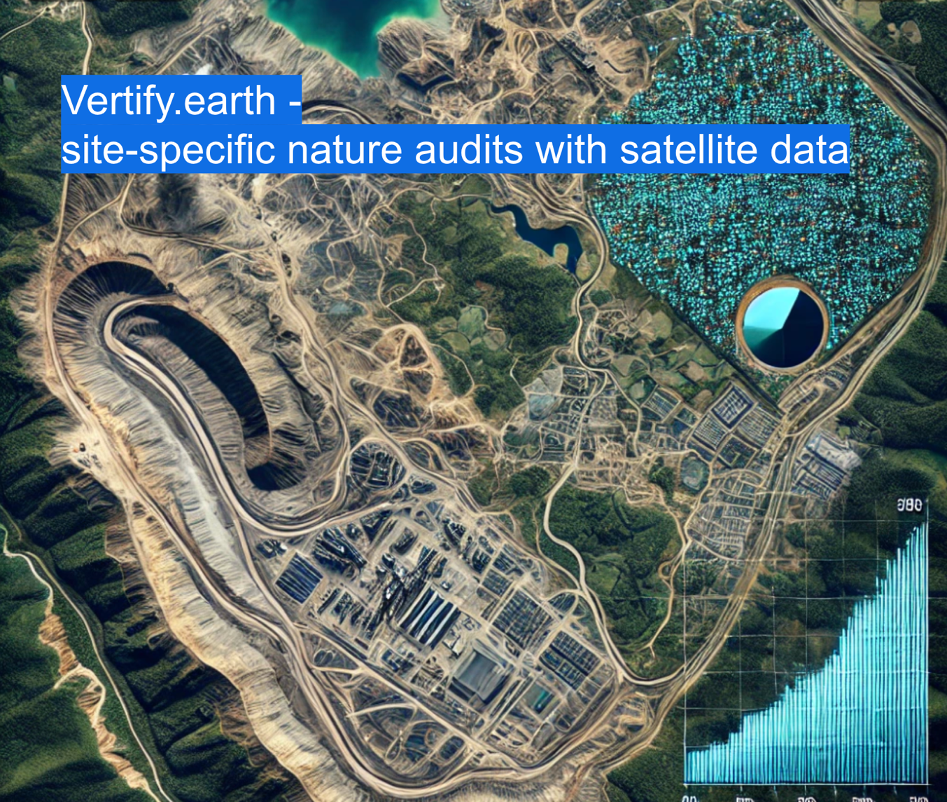
Vertify.Earth offers a solution by providing precise, site-specific nature audits. Leveraging satellite data, ground-truthing techniques, and advanced analytics, the service delivers actionable insights into land use, vegetation health, and biodiversity sensitivity. This empowers users to identify environmental risks, monitor progress, and implement strategies that not only protect ecosystems but also enhance the reliability and sustainability of their supply chains.
The activity focuses on developing tools and methodologies for robust environmental assessments. It aims to enhance data accuracy, usability, and alignment with global frameworks like the Science-Based Targets for Nature (SBTN). By combining geospatial analysis with ground-level observations, the project ensures a holistic approach to measuring impacts and dependencies on ecosystems.
Ultimately, Vertify.Earth enables informed decision-making, improving environmental outcomes and bolstering the resilience of supply chains, while addressing the needs of businesses, policymakers, and conservation organizations.
Users and their needs
The primary users are environmental and livelihood organizations and their investors and donors, such as impact investors and development aid organisations. The first type of organizations aim to demonstrate the effectiveness of interventions, such as agroecological practices or afforestation projects, highlighting both positive impacts achieved and negative ones avoided. Investors and donors require transparent evidence that their funding supports meaningful environmental outcomes and avoids harm to biodiversity and ecosystems.
These users are based in French-speaking Africa (Burkina Faso, Mali) and South Asia (notably India), where conservation efforts are critical to addressing challenges like deforestation, land degradation, and biodiversity loss.
User Needs and Challenges
-
Integrated Data Analysis: A system that combines ground-collected data with satellite-based remote sensing for a comprehensive view of impacts.
-
Impact Measurement: Accurate, site-specific metrics to validate biodiversity improvements and assess ecosystem restoration.
-
Transparent Reporting: Clear, actionable insights for accountability to donors and compliance with investment standards.
Challenges
Ensuring seamless integration of diverse data sources, adapting tools to local realities, and maintaining accuracy and usability are key. Vertify.Earth addresses these needs by seeking to deliver robust, transparent solutions for measuring and managing nature-related impacts.
Service/ system concept
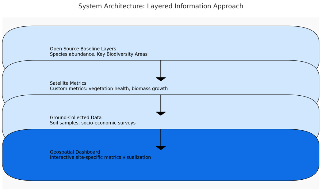
Vertify.Earth conducts bespoke, site-specific investigations, delivering insights through a layered approach tailored to users' needs. The service integrates coarse, satellite-based, and ground-collected data to measure and visualize environmental impacts on a geospatial dashboard.
Key Features and Layers of Information
-
Open Source Baseline Layers: Generic datasets, including species abundance maps and Key Biodiversity Areas, provide an initial understanding of the site.
-
Tailored Satellite Metrics: Custom satellite-derived measurements specific to the intervention, such as vegetation health for agroecology or biomass growth for forest restoration, are selected and applied.
-
Ground-Collected Data: Socio-economic surveys, soil samples, or biodiversity assessments from user partners enrich the analysis with localized, detailed insights.
-
Geospatial Dashboard: All data layers are visualized in an intuitive, interactive format, enabling users to explore site-specific metrics and generate actionable insights.
How It Works
The system starts with broad open-source datasets, refines them with tailored satellite measurements, and integrates ground-level data collected by partners. A cloud-based platform processes these inputs, producing custom maps and metrics that align with the specific impact to be measured. Users access the results via a dashboard, allowing them to explore metrics, track interventions, and export reports.
Space Added Value
Vertify.Earth integrates satellite data with local ground-collected data in bespoke, site-specific audits. Key space assets include Earth observation satellites such as Sentinel-2 and Landsat, providing high-resolution imagery to analyze land use changes, vegetation health, and ecosystem dynamics. These datasets are combined with global biodiversity layers and detailed on-site data to deliver comprehensive, tailored insights for each project.
Added Value of Space Assets
-
Wide Coverage: Satellites enable consistent monitoring over large and remote areas, overcoming the limitations of ground-only methods.
-
High Temporal Resolution: Regular satellite revisit cycles allow tracking of changes over time, such as biomass growth in afforestation or seasonal shifts in agroecological practices.
-
Scalability: Satellite-derived metrics are repeatable and cost-effective for monitoring multiple locations simultaneously.
-
Customization: Specific geospatial metrics, such as vegetation indices (NDVI) or carbon biomass, are tailored to address the unique needs of each project.
The approach’s unique value lies in its integration of geospatial and localized data. This combination enables bespoke, site-specific audits that provide precise and actionable insights, bridging the gap between global satellite capabilities and the granular understanding required for effective environmental management
Current Status
During the project, Vertify.earth developed two tailored prototype dashboards that demonstrate the power of spatial intelligence for nature impact reporting:
-
In Africa, we partnered with a conservation-focused NGO to support the transition to agroecological farming practices. The prototype allowed the organization to monitor changes in soil health, vegetation cover, and water availability across their intervention sites. This helped them track ecological improvements over time, strengthen donor reporting, and guide adaptive management on the ground.
-
In the Indian Himalayas, we worked with an impact investor aiming to assess the nature dependencies and impacts across multiple portfolio companies operating in fragile ecosystems. The dashboard provided site-level insights into land-use change, forest integrity, and biodiversity pressures—enabling the investor to better understand environmental risks, report to funders using IRIS+ indicators, and guide future investment strategies aligned with nature-positive outcomes.
Both use cases relied on a modular architecture that combined satellite-derived layers (e.g., NDVI, land cover change, biomass) with ground-collected socio-economic data. By translating complex environmental metrics into clear visual formats—maps, charts, and customizable indicators—Vertify.earth empowers a wide range of stakeholders to make informed, evidence-based decisions for people and planet.
Prime Contractor(s)
Subcontractor(s)