

Objectives of the service
Seismic hazard management often relies on historical data and static hazard maps that lack detailed local insights and timely updates, limiting effective planning and rapid response. To address this challenge, WAY4WARD is developing the Seismic Hazard Forecasting & Evaluation for Resilience (SAFER) service. SAFER aims to provide users such as government agencies, municipal planners, infrastructure operators, insurers and financial institutions with detailed, real-time seismic hazard maps and forecasts tailored to their specific locations and needs.
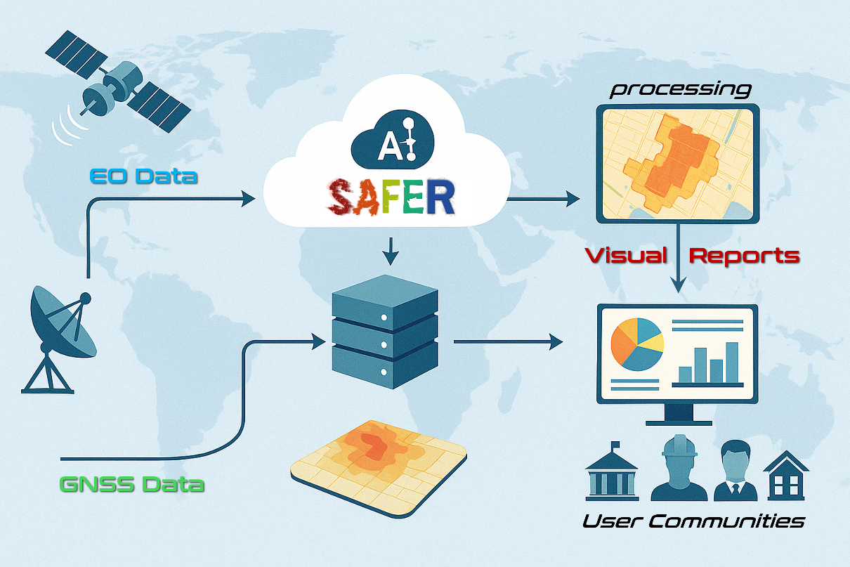
The service combines satellite-based Earth Observation (EO) and Global Navigation Satellite System (GNSS) ground deformation data with advanced algorithms and AI models to produce accurate, dynamic assessments and forecasts. Results are delivered through easy-to-understand, visually enriched reports designed specifically for non-technical decision-makers, enabling proactive disaster preparedness, improved infrastructure resilience and enhanced financial risk assessment.
The key objective of the current activity was to validate the alignment of the service with user requirements, confirm its technological readiness, and demonstrate the practical value of the solution through real-world pilot scenarios involving early adopter organizations.
Users and their needs
The SAFER service targets four primary user communities:
-
Government Agencies:
-
Hyperlocal seismic hazard mapping for precise urban planning.
-
Real-time hazard updates for emergency preparedness.
-
Regulatory compliance and enforcement tools.
-
-
Infrastructure Operators:
-
Accurate forecasts to strengthen infrastructure resilience.
-
Integration of seismic data into maintenance protocols.
-
-
Large Construction and Engineering Firms:
-
Comprehensive hazard assessments for infrastructure projects.
-
Tools to ensure seismic safety compliance.
-
-
Insurance and Financial Institutions:
-
Real-time seismic risk assessments to optimize underwriting.
-
Accurate, actionable data for financial risk management.
-
Targeted Countries: South & Central America, Middle East and Italy (initial engagements), with future expansion to other high-risk regions globally.
Service/ system concept
SAFER delivers real-time seismic hazard maps and forecasts by processing and combining satellite Earth Observation (EO) data with GNSS-based ground deformation measurements. Using proprietary algorithms and AI models, SAFER generates accurate and hyperlocal maps depicting seismic risk, helping users prepare proactively rather than responding reactively. The SAFER system includes three primary functions:
-
Data Collection and Pre-processing: EO and GNSS data acquisition.
-
AI-driven Analytics: Advanced algorithms and AI models for seismic risk estimation and forecasting.
-
Reporting and Visualization: User-friendly, visually enriched reports suitable for non-technical stakeholders.
Users receive either customized one-time reports or regular subscription-based updates (e.g. dashboards) to support urban planning, infrastructure resilience, insurance risk management and disaster preparedness.
Space Added Value
SAFER uniquely combines space-based assets, high-resolution Synthetic Aperture Radar (SAR) imagery and GNSS measurements, with advanced algorithms and AI models, significantly improving upon traditional seismic risk assessment methods. The key advantages include:
-
Higher accuracy and granularity: Hyperlocal forecasts down to 50-100 meter resolution, unavailable through traditional methods.
-
Real-time monitoring capability: Frequent updates provide dynamic risk insights compared to static, historical data-driven approaches.
-
Global scalability: The satellite data collection allows easy global replication without extensive local ground infrastructure.
This combination provides significant added value by enhancing accuracy, timeliness, and usability, substantially improving urban resilience and risk management
Current Status
The final review was held in April 2025, and the study has been completed.
SAFER successfully completed initial user engagement activities with some organizations. Technical feasibility was validated through a Proof of Concept (PoC) conducted with one of the first interested customers in Argentina, demonstrating effective integration of SAR and GNSS data to produce detailed seismic hazard risks estimation and forecasts. The PoC showcased SAFER’s capability to deliver visually enriched, hyperlocal seismic risk maps.
Prime Contractor(s)
