Objectives of the service
Managing the integrated water cycle involves a complex network of infrastructures: water reservoirs, dams, pipelines, wastewater treatment systems, and the energy networks that power them.
The SCIRES project—led by Planetek Italia in collaboration with ENEA and INGV—offers cutting-edge Earth Observation services that enhance the resilience of these infrastructures. SCIRES is part of the EISAC.it initiative, the Italian node of the European Infrastructure Simulation and Analysis Centre.
SCIRES is composed by three modules:
Pipeline Monitoring Service
Detects early signs of leaks and structural issues in pipelines by combining satellite radar data (EO), IoT sensors and AI algorithms.
Helps utilities reduce water losses and emergency repair costs by enabling predictive maintenance.
Ground Stability Monitoring Service
Tracks land deformation in areas where infrastructures are vulnerable to landslides or subsidence.
Based on Persistent Scatterer Interferometry (PS-InSAR) from Sentinel-1 imagery, enriched with GNSS and geological data, it provides millimetric accuracy and long-term stability trends.
Multirisk Assessment Service
Integrates the outputs from the above services into a comprehensive risk analysis platform.
It simulates cascading effects of natural hazards—for example, how an earthquake could damage pipelines and disrupt both water and power distribution networks.
This system-level approach supports more informed and resilient infrastructure management decisions.
Users and their needs
Only 3% of Earth’s water is freshwater—and just a fraction of that is accessible to humans.
Yet even this limited resource is poorly managed in many areas. In Europe, drinking water networks suffer an average 23% distribution loss, with peaks exceeding 35–40% in countries like Ireland, Malta, Romania and Italy.
Water utilities must prioritize maintenance activities months in advance to mitigate losses and avoid damage to interconnected infrastructures.
However, the market is highly fragmented: over 500 million EU citizens are connected to drinking water and wastewater services, and investments are unevenly distributed.
SCIRES addresses this challenge by helping utilities:
-
Detect risks before they become failures
-
Optimize maintenance and reduce emergency repairs
-
Improve infrastructure resilience and safety
Key end-users:
-
Acea Ato 2 SpA – managing over 8,000 km of pipelines in Rome
-
Hera SpA – serving large areas across Emilia-Romagna
The services are also valuable to civil protection agencies, regulators, and insurers.
Country targeted: Italy, Europe
Service/ system concept
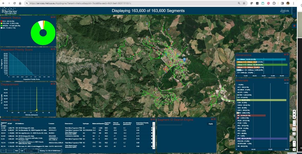
SCIRES services are delivered through Rheticus® Network Alert, a cloud-based Decision Support System. It acts as a central hub for:
-
Pipeline anomaly detection
-
Ground deformation monitoring
-
Vulnerability and risk scenario analysis
The platform enables users to access geospatial and environmental information, monitor asset conditions, and assess risks linked to extreme events (e.g. heavy rainfall, earthquakes).
Space Added Value
SCIRES uses radar data from Sentinel-1 satellites and Persistent Scatterer Interferometry (PS-InSAR) to detect ground displacement with millimetric precision.
By processing long-term stacks of SAR images, the system identifies coherent targets (typically urban structures) and produces detailed time series of ground movement.
These data are fundamental for:
-
Monitoring land stability
-
Identifying risks near pipelines and reservoirs
-
Supporting predictive maintenance planning
GNSS In-situ Monitoring
GNSS sensors complement EO data by offering continuous 3D positioning at specific locations.
They are particularly useful in areas where PS targets are sparse.
Together, EO and GNSS provide a robust and interoperable monitoring system.
Current Status
The SCIRES project was successfully completed in September 2025. Two operational pilots were conducted to validate the services:
Pilot 1 – Hera (Zocca, Emilia-Romagna)
Pilot 2 – Acea (Magliana pipe-bridge, Rome)
Across both pilots, users accessed services via the Rheticus® portal, using intuitive dashboards and geo-analytics tools.
Key Performance Indicators (KPIs) confirmed:
-
High anomaly detection accuracy
-
Strong system reliability
-
Clear operational value