Objectives of the service
Surface Water and Land Use Monitoring addresses a critical gap in current water detection systems. Municipalities, agricultural providers, and environmental services struggle to identify smaller water bodies using conventional satellite monitoring, often resorting to expensive aerial surveys that provide only periodic snapshots.
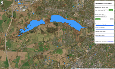
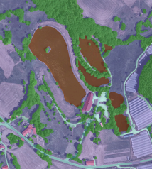
Our service combines advanced deep learning algorithms with Sentinel-2 multispectral satellite imagery to detect water bodies as small as 400 m² from satellite data and 4 m² from aerial imagery. The service delivers continuous water monitoring through an intuitive web platform and standardized Application Programming Interfaces (APIs), enabling seamless integration with existing Geographic Information System (GIS) workflows. Users receive timely, accurate water mapping at substantially lower costs than traditional methods.
This Kickstart project focuses on three key objectives:
-
Developing reliable water detection algorithms for both high-resolution aerial and enhanced satellite imagery
-
Validating technical feasibility across diverse environments and use cases 3. Creating a sustainable business model that delivers significant value in multiple domains, including municipalities managing flood risks and agricultural technology providers optimizing irrigation
The project responds directly to increasing climate variability, where more frequent extreme weather events demand better tools for water resource management and environmental monitoring.
Users and their needs
The service targets three distinct customer segments with specific needs:
Government and Municipal Authorities
-
Need reliable detection of flood-prone areas after rain events
-
Require cost-effective alternatives to expensive annual aerial surveys
-
Seek data to support climate adaptation planning and verification of water regulations
Agricultural Technology Providers
-
Need accurate irrigation planning tools and standing water detection
-
Require API access for integration with existing farm management systems
-
The service targets three distinct customer segments with specific needs:
Government and Municipal Authorities
-
Need reliable detection of flood-prone areas after rain events
-
Require cost-effective alternatives to expensive annual aerial surveys
-
Seek data to support climate adaptation planning and verification of water regulations
Agricultural Technology Providers
-
Need accurate irrigation planning tools and standing water detection
-
Require API access for integration with existing farm management systems
Environmental Services Companies
-
Need consistent monitoring of water levels, e.g., for carbon credit verification ● Require detection of smaller water bodies across large wetland areas
-
Seek reliable data for compliance reporting and ecosystem management
All users benefit from our service's ability to detect small water bodies that current satellite solutions miss, providing critical insights for water resource management, operational planning, and regulatory compliance.
Service/ system concept
The architecture consists of three main components: data retrieval and preparation, which collects and enhances satellite imagery; the analytics engine, which detects and maps water bodies; and the delivery platform, which provides user access through web interfaces and APIs. This modular design enables continuous improvement of each component while maintaining reliable service delivery.
The service is delivered through Atla.ai's established SaaS platform, which provides both intuitive web-based visualization and standardized APIs for integration with customer systems. Users can access water body mapping data through OGC-compliant interfaces or REST APIs, enabling seamless integration with existing workflows and systems.
Space Added Value
Current high accuracy water monitoring relies on expensive aerial surveys. By enhancing Sentinel-2 data through, the Surface Water and Land Use Monitoring service leverages ESA satellite data to deliver substantially improved monitoring capabilities at a fraction of the cost. The service transforms raw satellite data into actionable information by significantly improving the detection of smaller water bodies that existing satellite-based solutions miss.The space-based approach enables consistent, wide-area coverage without the logistical challenges of aerial surveys.
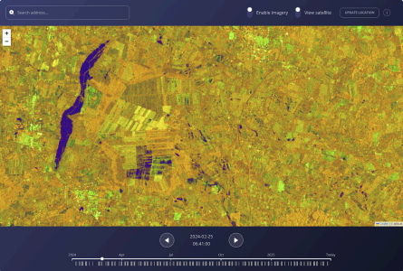
The service design also lays groundwork for future integration with Sentinel-1 radar data, which will enable all-weather monitoring capabilities regardless of cloud cover. This combined use of multiple Copernicus space assets would create a comprehensive monitoring system superior to current methods, providing continuous water mapping even in regions frequently obscured by clouds.
Current Status
The Surface Water and Land Use Monitoring Kickstart project has demonstrated that reliable detection of small water bodies using enhanced Sentinel-2 imagery is technically feasible and economically viable. Our testing confirmed that detecting water bodies as small as 4 m² in aerial imagery and 400 m² in satellite imagery is achievable, though further technical refinement is required before full commercial deployment. Next steps include extending the service to incorporate Sentinel-1 radar data, which in addition to increasing accuracy, also would provide all-weather monitoring capabilities.
The project confirmed the economic viability of the service, with potential customers across municipal, agricultural, and environmental sectors acknowledging its significant value. As climate change drives increased rainfall and flooding events, the need for reliable water monitoring solutions will only grow, and this project has established a promising foundation for addressing this need, at a commercially viable price point.