
Objectives of the service
VARESAS aims to solve a critical gap in emergency and disaster response: the lack of real-time, integrated situational awareness for rescue teams. Today, first responders often operate without a unified system that consolidates information such as the location of victims, hazards, or damaged infrastructure. Data is collected manually, maps are often outdated or printed, and coordination across teams is limited.
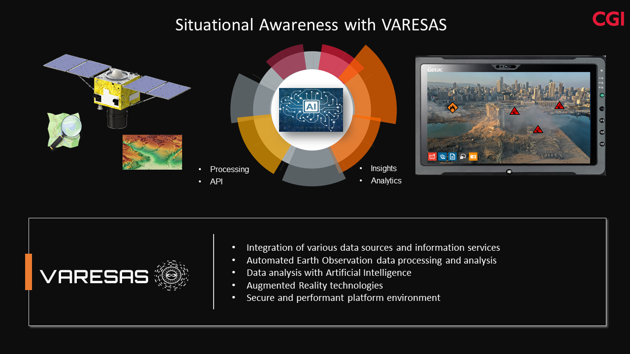
VARESAS provides a cloud-based platform that brings together satellite imagery, drone data, environmental information, and field reports into a single operational picture. It uses advanced technologies like augmented reality, artificial intelligence, and machine learning to visualize risks, predict developments, and support decision-making in the field. The system enables more effective planning, faster reaction times, and better coordination among response units.
The project’s objective is to develop, validate, and prepare the service for market readiness by working closely with operational users such as search and rescue organizations and civil protection agencies. This includes testing the solution in real-world scenarios, optimizing its usability, and ensuring its adaptability across sectors such as government, industry, and humanitarian aid. Ultimately, VARESAS aims to increase the safety, speed, and effectiveness of emergency operations.
Users and their needs
The VARESAS service is currently targeted at operational user communities in Germany, including search and rescue teams, fire brigades, and civil protection authorities. Key users involved in the project include I.S.A.R. Germany (International Search and Rescue) and regional emergency services, who are actively participating in testing and validating the solution.
These users face several challenges in their day-to-day operations:
-
Lack of integrated systems to consolidate real-time data from multiple sources
-
Reliance on printed or static maps with outdated infrastructure or hazard information
-
Limited situational awareness during fast-evolving crisis scenarios
-
Manual communication and coordination across teams and command structures
-
Difficulty accessing current satellite or aerial imagery during missions
User needs:
-
Real-time operational overview with integrated data (satellite, drone, environmental)
-
Easy-to-use field interface with visual overlays and mobile access
-
Reliable communication and coordination tools, even under adverse conditions
-
Fast deployment and configuration tailored to mission requirements
-
Support for risk analysis, route planning, and hazard identification
The main challenge for the project is to tailor the solution’s advanced features—such as data fusion, augmented reality, and artificial intelligence—to be intuitive, field-ready, and fully aligned with operational workflows in high-stress environments.
Service/ system concept
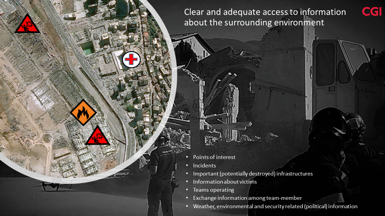
VARESAS provides rescue teams with a clear, real-time overview of the situation during emergencies. It collects and combines data from various sources—like satellites, drones, sensors, and field reports—into one single map-based interface. This allows users to see the location of damaged infrastructure, hazard zones, team members, and possible evacuation routes, all in real time.
Key features include:
-
Live mapping of crisis zones
-
Visual overlays showing danger areas, victims, and rescue routes
-
Integration of satellite and drone imagery
-
Augmented reality support for on-site visualization
-
Secure team communication and coordination tools
The system is designed to be simple to use: rescue workers can access the platform through tablets or smartphones, view updated maps, share photos, and communicate directly with team members or command centers.
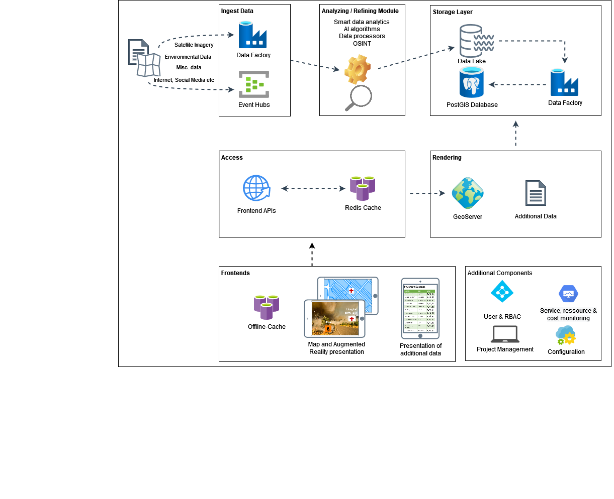
How it works (high-level architecture):
-
Data Sources: Satellite images, drone feeds, sensors, and field inputs
-
Cloud Platform: All data is processed and fused in a secure cloud environment
-
User Access: Teams access the service via mobile devices or control rooms
-
Visualization: The platform displays a live, interactive map with key insights
Here’s a visual representation:
Space Added Value
VARESAS makes extensive use of Earth observation satellites to provide up-to-date imagery of disaster-affected areas. These satellite images help identify damaged infrastructure, flooded regions, blocked roads, or areas at risk—often before teams arrive on site. Unlike traditional methods that rely on manual reporting or outdated maps, satellite data offers a broad, real-time view of the situation, even in remote or inaccessible locations.
The platform also benefits from Global Navigation Satellite Systems (GNSS), such as GPS, to geolocate rescue teams, assets, and incidents with high accuracy. This enables precise coordination and tracking during dynamic operations.
The added value of combining space-based data with ground-level inputs lies in its speed, coverage, and accuracy. While competitors may rely on fixed infrastructure or local sensors, VARESAS delivers a scalable solution that works even in areas with limited connectivity or damaged ground networks. Satellite data ensures coverage regardless of terrain or national borders, giving users a clear operational advantage.
By integrating space assets with artificial intelligence, VARESAS turns raw satellite data into actionable insights—something most existing systems do not offer—allowing for faster decisions, better planning, and more effective crisis response.
Current Status
VARESAS is currently in production and commercialization phase. Field tests were successfully conducted in Germany, including an environmental inspection mission at a red mud disposal site in collaboration with AOS Stade GmbH and the Lower Saxony Water Authority (NLWKN). Additionally, operational feedback was gathered through live trials with I.S.A.R. Germany during simulated deployment scenarios. The platform was presented at two national trade events—INTERGEO and RES-Q-EXPO—where interest from civil protection agencies and port authorities was confirmed. Ongoing work includes extending drone data integration and refining the augmented reality interface for mobile use. Preparations are underway for migrating the service from a public to a hybrid cloud environment, to meet data sovereignty requirements of government users. Activities after the conclusion of the project include a second round of field validation and the launch of targeted sales campaigns within Germany’s civil protection and industrial emergency response sectors.