Objectives of the service

Wildfires are one of the most destructive climate-related hazards, threatening lives, ecosystems, and billions in infrastructure and economic value. Most spending is focused on response and recovery, while less than 10% is directed to prevention.
This project addresses that gap by developing a cost-effective, scalable platform to assess wildfire risk in the preparedness phase.
The service combines Earth Observation data with AI-based analytics to:
-
Map vegetation proximity, structure, and flammability near assets
-
Assess vegetation connectivity and potential fire spread pathways
-
Provide actionable risk scores for infrastructure managers, utilities, and landowners
-
Support vegetation management planning (pruning, backburning, firebreaks) prior to fire seasons
Users and their needs
The demonstration project engaged two main pilot clients:
-
Jogosa (Spain, Forest and Infrastructure Manager) – managing forest and infrastructure assets in Extremadura, they require risk assessments to optimise vegetation management and reduce fire risk.
-
Prosolia (Europe-wide, Solar Farm Developer/Operator) – managing solar PV installations across Spain and Portugal, they seek to understand wildfire risks near critical energy assets and to protect PV infrastructure.
Both clients require precise, scalable insights that help them prioritise vegetation suppression activities, reduce operational risk, and protect their investments.
Service/ system concept
The service leverages:
-
Sentinel-2 and 3 imagery for vegetation mapping and flammability indicators
-
VHR satellite and/or Lidar data for vegetation height and structure
-
AI/ML models for tree detection, connectivity mapping, and vegetation risk scoring
-
Hybrid cloud + HPC architecture for efficient data processing and large-scale scalability
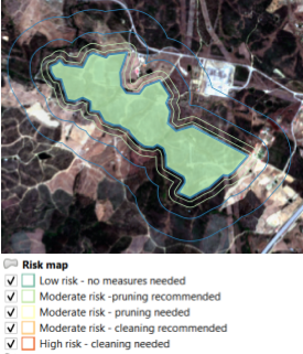
Outputs are delivered as:
-
Raster wildfire risk maps at 1m resolution
-
Asset-level wildfire risk scores for utilities, solar farms, and infrastructure operators
-
Access via OGC-standard APIs (WMS/WFS) for integration into client GIS systems

Space Added Value
The service builds on the Copernicus Sentinel constellation, delivering global, repeatable coverage at low cost.
-
Sentinel-2: vegetation extent, proximity, flammability
-
Sentinel-3: vegetation water stress for flammability
-
High-resolution satellite data and national Lidar datasets enhance precision
By using open EO data sharpened with AI techniques, WEO provides detailed risk maps at a fraction of the cost of traditional airborne surveys.
Current Status
The wildfire preparedness extension of WEO’s TreeMonitor product line has successfully completed pilot demonstrations with Jogosa and Prosolia.
-
System Verification (FAT & SAT) testing confirmed accuracy of vegetation proximity, height, and flammability components.
-
Pilot Utilisation showed strong client engagement, validating business value and usability.
-
KPIs achieved: >99% uptime, >85% accuracy vs Lidar benchmarks, client feedback confirming fit-for-purpose risk prioritisation.
The service is now at pre-commercial stage, with potential roll-out to utilities, municipalities, insurers, and energy developers across southern Europe, Australia, and North America.
Prime Contractor(s)