
Objectives of the service
Creating green spaces around urban assets deliver proven benefits: cooling during heatwaves, reduced nose, cleaner air, and improved health and wellbeing. They also enhance property value - an effect increasingly reflected in asset valuations and insurance premiums, for example by CBRE. Yet, investment in nature is often limited by high opportunity and maintenance cost.
Today, organizations managing green infrastructure still depend on costly manual inspections and fragmented data. This makes it difficult to demonstrate impact, plan effectively, or secure long-term returns. Asset managers face growing pressure to meet sustainability standards while protecting portfolio value, while green solution providers lack the tools to verify impact and performance and build lasting client trust.
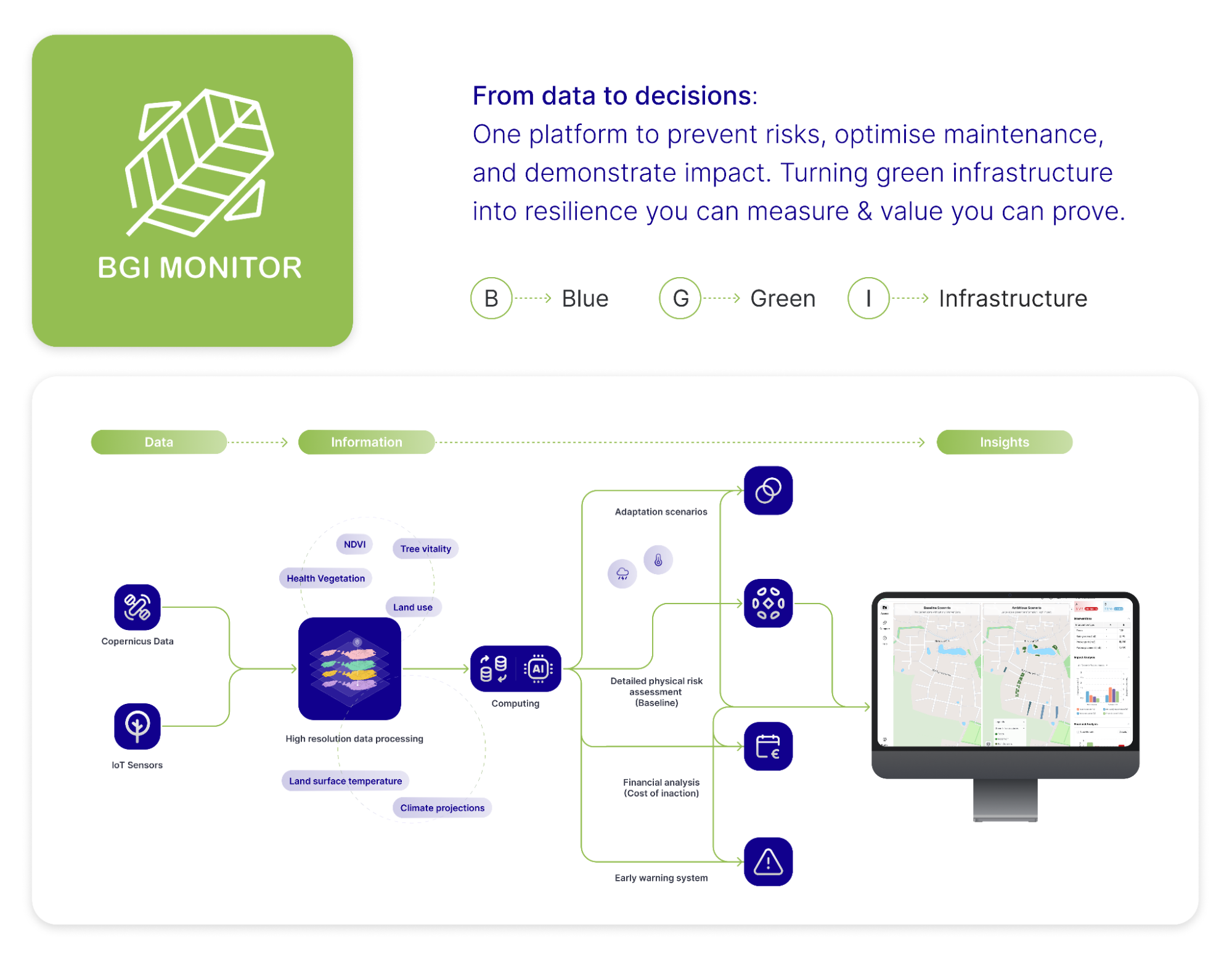
BGI-Monitor addresses these challenges by combining Copernicus and Sentinel Earth Observation data with IoT sensors and high-resolution models. Through dashboards, alerts, and reports, it provides a real-time view of vegetation health, soil moisture, and urban heat. Users can detect risks early, plan preventive maintenance, and run scenario simulations such as droughts or heatwaves. For long term investment decisions, BGI monitor helps to find the right location and vegetation type to drive robust resilience outcomes.
To date, 20 companies have been approached and 8 expressed interest in running a pilot. Based on this pipeline, three to five pilots will go into our pipeline for demonstration. These will generate concrete evidence on technical performance, user value, and integration into daily workflows, providing the foundation for wider deployment and future demonstration projects.
Users and their needs
The user research in this project focuses on two main user segments:
ASSET MANAGERS (BUILDING FOCUS) | Developers, asset managers, and property investors designing, financing, and maintaining sustainable, climate-resilient urban projects.)
GREEN SOLUTION PROVIDERS | Organizations providing complementary green infrastructure, environmental monitoring, and climate adaptation solutions that seek to strengthen their offerings, impact verification, and partnership opportunities.
User needs
Asset managers
-
Assess climate risks to protect asset value.
-
Demonstrate sustainability compliance and progress to investors.
-
Optimise operational costs linked to landscaping and maintenance.
Green solution providers
-
Difficulty proving and quantifying climate or biodiversity impact.
-
Need for monitoring and maintenance tools to sustain client engagement.
-
Justify budgets and return on investment with credible evidence.
Challenges for the Project
-
Combine Earth observation, IoT, and other data into a consistent service.
-
Deliver actionable dashboards and reports, not raw data.
-
Ensure outputs fit existing workflows and reporting requirements.
-
Prove measurable benefits within pilot projects.
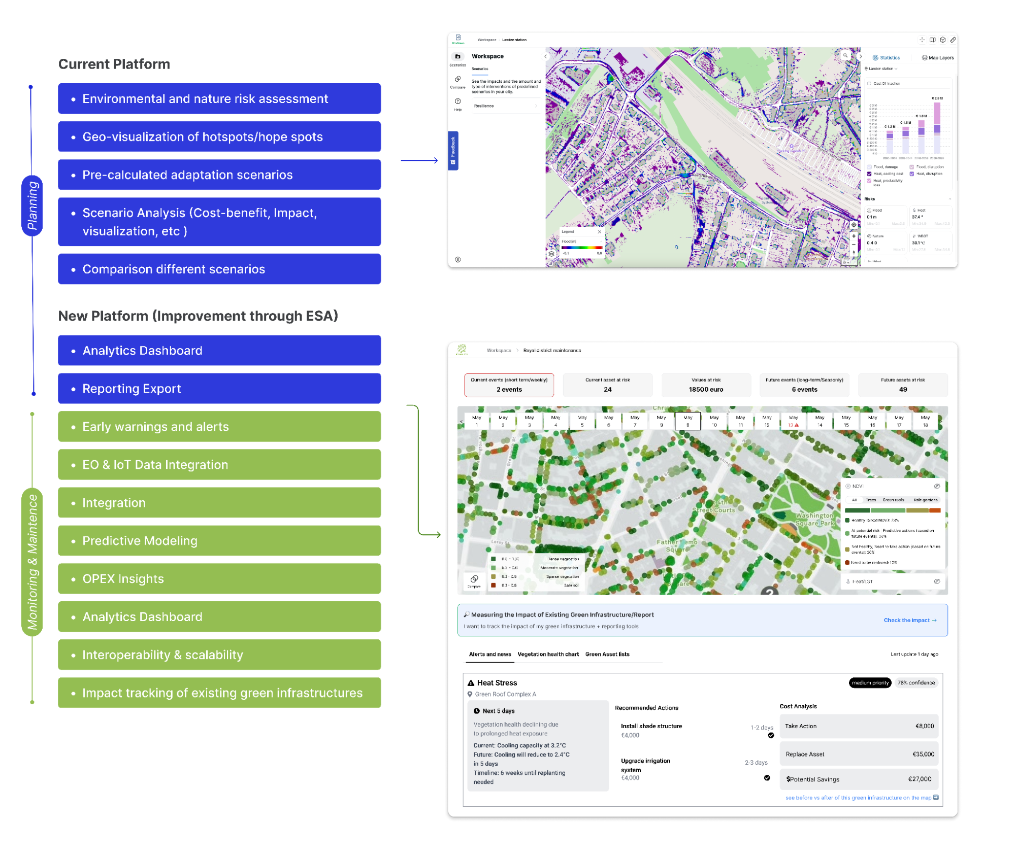
Service/ system concept
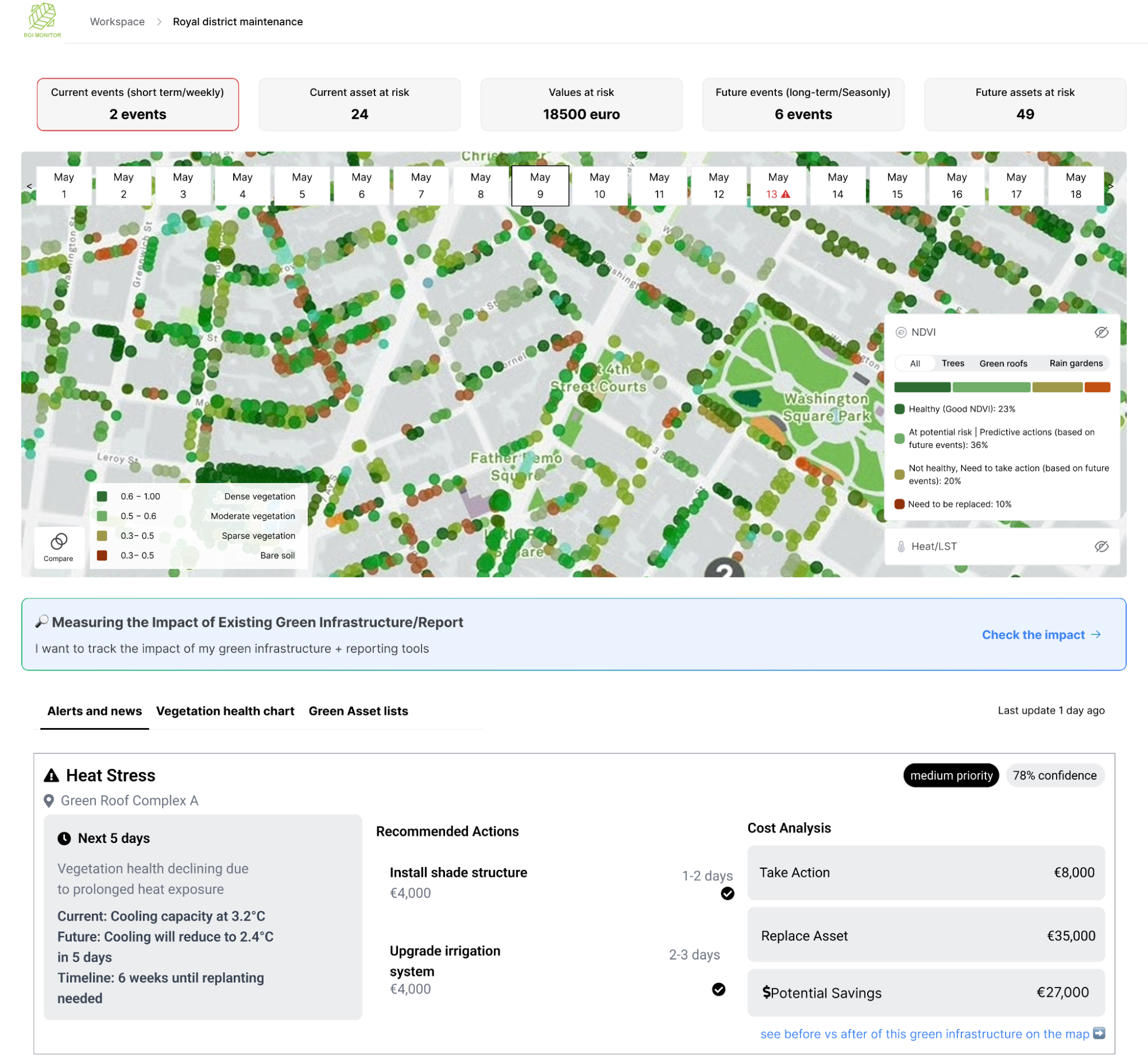
The BGI-Monitor is a single platform that provides information on the health and performance of green infrastructure. By identifying high-risk areas early, it supports preventive maintenance, optimises resource allocation, and reduces operational costs. Users access these insights through dashboards, automated reports, and early-warning alerts. In addition, scenario modelling allows them to simulate events such as droughts or heatwaves and plan interventions before problems occur.
Key features tested in this project include:
-
Early warnings before damage occurs
-
Hotspot maps showing priority areas prone to vegetation stress
-
Scenario modelling of droughts and heatwaves
-
Reporting tools to communicate benefits and compliance
In simple terms, BGI-Monitor brings together space and ground data. Copernicus and Sentinel Earth Observation satellites monitor vegetation and climate impacts from above. IoT sensors measure vegetation and soil conditions locally. This information is combined with climate models and displayed in dashboards and reports, so users can see risks, plan maintenance, and demonstrate the impact of green infrastructure.
Space Added Value
Space assets are indispensable for the delivery of the service, as heat maps, vegetation monitoring and predictive modelling and maintenance advisory are all dependent on one or a combination of below assets:
-
Copernicus ERA5: Core baseline for LST and atmospheric variables.
-
Sentinel-2: fused with other data for enhanced resolution on NDVI, vegetation indices.
-
Galileo (optional): Improves IoT sensor positioning and mapping accuracy.
These provide reliable, continuous, and high-resolution information on vegetation health, soil moisture, land surface temperature, and drought stress.
This information will be combined with IoT sensors data and weather data to create predictive models and enable early detection of risks, hotspot mapping, and scenario modelling of climate events such as droughts and heatwaves.
The added value of combining Copernicus and Sentinel with ground sensors is the ability to cover large urban areas consistently and at lower cost. Competing solutions often focus mostly on agriculture (e.g. EOS Data Analytics, World From Space) or use satellite-only monitoring without integration of sensors (e.g. Spottitt). By contrast, BGI-Monitor delivers a scalable platform tailored to urban green infrastructure, moving from manual, reactive maintenance to proactive, data-driven management.
Current Status
Achievements
- User and market research to establish a business model for high-resolution urban nature and climate risk monitoring.
- Partnerships for hardware (sensors) and climate data are active (e.g., with TreeSense, Climate Scale)
- Optimization of adaptation scenarios.
- The technical architecture covers high-resolution data streams, sensor integration, and basic dashboards for scenario modelling and impact reporting.
- Product requirements and integration needs are defined through discussions with stakeholders and technology partners.
- Integration and technical development are active for new data sources (e.g., IoT sensors, remote sensing pipelines) and analytics modules.
- Usability and reporting features are being revised based on early feedback from stakeholders and expert partners.
- Built the project technical structure based on satellite imagery and proprietary models.
- Defined an initial pricing range based on market research.
- NDVI-based modelling for tree analysis.
Next Activities
- Pilot project with 4 green solution providers.
- Market sizing and commercial model validation continue as more customer interviews and benchmarking take place.
- Technical integration tasks with municipal and partner platforms are planned, focusing on system interoperability and reporting.
- Finalise pricing structure and direct sales (inbound and outbound).
- A post-MVP launch workshop with potential end users is planned to gather feedback and validate use cases.
Prime Contractor(s)
