
Objectives of the service

Users of our 3D scanning equipment express following needs for some of their use-cases:
-
Improved model accuracy
-
Models referenced in a global coordinate system
-
Increased ease-of-use due to enhanced real-time information
-
More informative presentation of the final3D model
The objective of this project is to provide:
-
A commercially ready solution that fulfil the needs expressed by the users and customers,
-
Based on UVisions exiting products,
-
Integrating the right sensors to benefit from the use of GNSS (Global Navigation Satellite System) and RTK (Real-Time Kinematic) data
Users and their needs
UVisions current customers and users can be found in following segments: infrastructure owners, consulting engineers and sub-contractors within surveying and engineering. The customers and users are found worldwide.
Four companies within these segments are participating as customers and partners in this project: Niras (DK), Arcadis (NL/UK), Amey (UK) and Drechsler Marine Consult (DK).
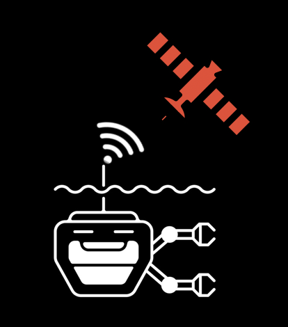
Service/ system concept

This project develops the following elements referring to the figure above:
-
Positioning solution USBL (Ultra Short Base Line System) or similar for ROV/diver mounted and RTK receiver for pole mounted
-
UVision Control SW (UController) – which provides the control interface for the user and also the interface to the positioning solution
-
UVision Scanner (UScanner) – which captures scan data with the positioning and provides a real-time 3D point cloud to the UController based on a Simultaneous Localisation and Mapping algorithm.
-
UVision Cloud Services – hosts the post-processing pipeline which creates the high resolution and scaled 3D models.
-
UVisualiser – provides visualisation of the 3D model.
Space Added Value
In terms of space assets, the GNSS system is used – reached by use of GNSS/RTK receivers. The benefits for the different customer segments are to a wide extend overlapping:
-
More reliable and consistent real-time 3D model improves the quality of the captured data
-
Highly accurate models mean that models can be compared, and changes monitored over time
-
Location of points of interest is clear helping avoid errors and misunderstandings
-
Positioning helps that models can be easily incorporated into customers GIS/CAD modelling tools and compared with existing asset models
-
Positioning provides the ability to create larger models by accurately combining smaller models
-
Faster and more effective model processing
Current Status

UVision attended Oceanology International in London invited on the stand L350 by The ROV manufacturing company Chasing Innovation Tech. This also gave us an opportunity to advertise our ongoing demonstration project.
Solution architecture has been finalised.
Integration of the defined hardware is ongoing. And agreements have been made with the involved equipment suppliers.