
Objectives of the service
3DE is a Platform-as-a-Service (PaaS) solution targeted at the energy sector that facilitates the management of geospatial data for Right of Way Management and Asset Inspection of electricity powerlines and gas pipelines. 3DE utilises remote sensing technologies (satellite, aircraft and drones) combined with machine learning techniques to improve predictive maintenance work practices, specifically addressing issues such as vegetation encroachment and structural defects.
3DE aims to address with its solution a global problem that the energy sector is facing relating to the collection, storage, and management of large volumes of geospatial data of their assets. The 3DE solution can be broken down into several key stages set out in Figure 1 below:
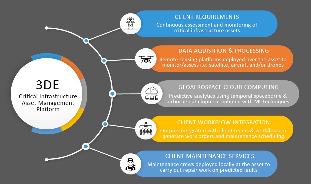
Title: 3DE Overview Infographic
Image credit: GeoAerospace Ltd. Project :3DE
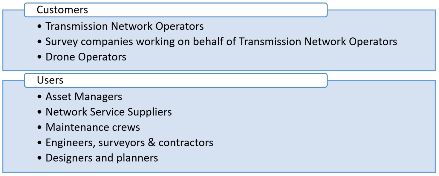
Users and their needs
3DE customers are network operators, survey companies and drone service providers with a varied mix of end-users including asset managers, GIS teams and data collection teams (field operators & maintenance managers). The primary target users (transmission and distribution managers of Transmission Network Operators) are responsible for the overall management of the assets, whilst the service suppliers are responsible for maintaining the network and can include, for example, engineers, vegetation, and asset integrity managers.
To reduce costs and increase safety and efficiency, Transmission System Operators are pivoting away from traditional forms of manual visual inspection and are utilizing automated remote sensing technology (airborne and spaceborne data streams) to digitize their networks. Maintaining linear infrastructure involves routinely scheduled visual monitoring and inspection, which is time-consuming, expensive, and often hazardous. This preventative approach focuses on the age of the asset and predetermined maintenance schedules and as a result, the asset can fail during inspection cycles, leading to increased repair costs and serious risk to public safety. Changing from the traditional approach to an automated, predictive approach involves a significant shift in management practices and operational procedures, specifically in terms of data management and this is where 3DE offers a solution.
3DE will be tested with industry collaborators locally in Ireland, to utility companies around the world.
Service/ system concept
A simplified conceptual architecture has been devised to address the service requirements which has key data layers, data platform modules and core services. The data layers comprise GIS, spaceborne remote sensing as well as aerial data inputs which include RGB imagery, multispectral, video and LiDAR data.
The 3DE system architecture enables inputs from Satellite Earth Observation data (e.g., Copernicus Sentinel 1 & 2, LandSat) which determine where and when aircraft/drones should be configured, deployed and operated over linear surface networks. This initial macro scale assessment therefore reduces the need to locally assess areas of least concern.
The introduction of a novel computational architecture will underpin the analysis of satellite data at a macro scale. This will be supported by a system for targeted management of these assets based on a reinforcement machine learning framework which aims to dramatically reduce the need and provide more focused micro scale assessment.
Hereby 3DE focuses on the two main service areas RoW Management and Asset Inspection.
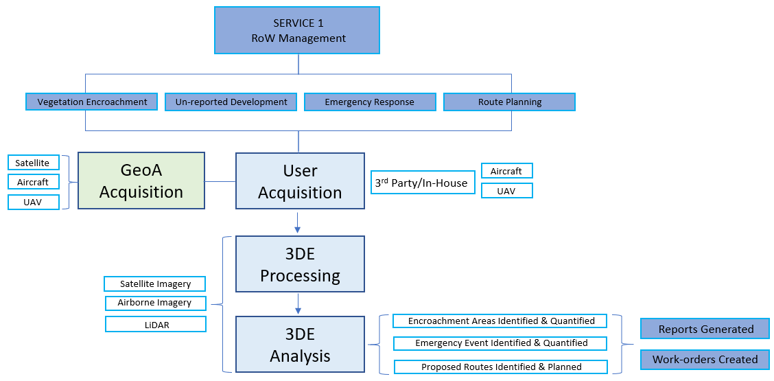
Title: Workflow Diagram for Vegetation Management
Image credit: GeoAerospace Ltd. Project : 3DE
Space Added Value
Network Operators using the 3DE service will have direct access to Earth Observation data primarily for RoW and vegetation encroachment assessment. This includes:
- Sentinel 1 (30m) SAR data used for synoptic RoW Assessment and emergency management i.e., surface motion (landslide/subsidence) and flooding events.
- Sentinel 2 (10m) optical (VNIR & SWIR) used for macro scale vegetation monitoring.
- 3rd party missions which provide access to VHR Panchromatic e.g., Pleiades-1A (0.5m) and Spot 5/6 (<10m NIR) for emergency response & vegetation encroachment.
EO data will enable the end user to build-up valuable time-series data to determine patterns of growth/development and help with fault predictions. Early signs of vegetation encroachment can be detected by combining VHR satellite data and vegetation growth models. In addition, human-activity & development (cleared earth, new roads, trails) can also be detected and issues such as land stability in peatland/blogland areas (InSAR and S1) can also be detected.,
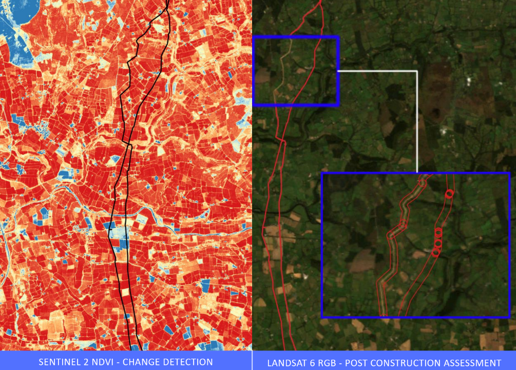
Image: 3DE SatEO (Sentinel-2 & Lansat 6) data utlised as part of macro-scale infrastructure assessment
Image credit: GeoAerospace Ltd. Project: 3DE
Current Status
Throughout 2020, end-users were engaged and the 3DE concept developed through discussions with utility providers in Ireland. Dedicated workshops and targeted interviews were also held to determine the technical viability of the service. This was done in combination with a detailed review of the European and global market size and potential market for 3DE.
The KS activity is now concluded and GeoAerospace plans to apply for a demonstration project under ESA’s BASS program (for the development of the service) later in 2021.
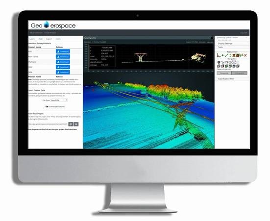
Image: GeoAerospace 3DE Geospatial Data Viewer
Image credit: GeoAerospace Ltd. Project : 3DE