Objectives of the service
With ever increasing rail traffic, asset managers are consistently challenged to improve the performance of the railway network. Both availability and reliability of rail tracks are key concerns and need to be maximised in order to optimise operational efficiencies and ensure safety. Accurate monitoring is a key enabler for effective maintenance operations that include, for example rail track condition monitoring, tamping, and other track works.
The most desirable outcome is to achieve a supportive continuous monitoring of the entire network and to deliver significant ongoing savings in conventional monitoring and maintenance costs with minimal upfront investment. This could possibly be achieved through the strategic exploitation of wide area satellite data to identify hotspots for more intense monitoring activity.
Users and their needs
Three main customer/user segments are involved in the maintenance of railway infrastructure:
- Asset managers: Day to day maintenance of railway infrastructure is the responsibility of the national railway authorities, who act in the role of asset managers/owners. They are required to continuously monitor the whole network and to take appropriate measures to ensure operations and safety.
- Service providers: In several countries (e.g. the Netherlands, Sweden) the role of the asset managers in maintenance planning and execution is outsourced to service providers/contractors.
- Engineering companies: Asset managers use the advice of engineering companies for some of the technical issues, such as advising on appropriate measures to ensure operations and safety.
Currently, railway infrastructure is inspected both visually as well as by dedicated video and measurement trains that monitor the condition of the railway network. Based on this information, track maintenance operations are planned and executed. The disadvantages of this current approach are the low frequency of both measurement trains and visual inspections due to the relatively high costs of increasing the frequency of these types of operations.
Stakeholders are therefore looking for a solution that can provide monitoring of the entire network on a more frequent basis. In order to achieve this, a solution that is nonintrusive, has readily available data, can improve existing prediction models and does not need major investment in new assets or infrastructure is highly desirable.
The country/countries of the targeted users are:
Targeted users are based, initially, in the United Kingdom, the Netherlands, Germany, France, Spain, and Sweden. The service will eventually be extended across the whole of Europe.
Service/ system concept
Service Concept
The concept is that satellite monitoring can enrich the analysis/prediction of track/terrain settlement behaviour including the identification of possible ‘hotspots’ in the network that are under threat (substructure stability and terrain deformation, e.g. due to existing geohazards such as mining or slow-moving landslides). The RailSAT service intends to provide continual monitoring at a regional level through the exploitation of Earth observation satellite data to provide wide–area ground deformation rates and identify hotspots. The identification of these hotspots informs the need for more intensive monitoring.
By using a step by step approach several types of analyses are possible:
- Regional analysis to qualitatively investigate overall terrain deformation trends such as slow-moving landslides, mining-induced subsidence or uplift, etc. that may have an impact on the track or corridor.
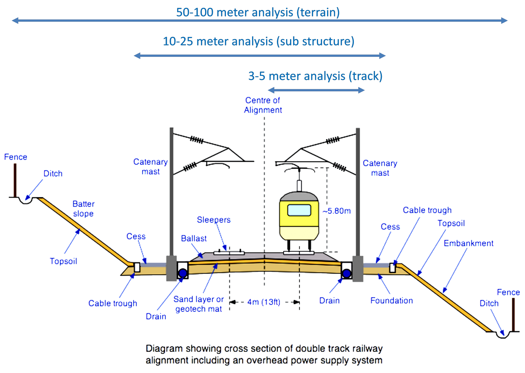
- 50-100 m corridor & wide-area analysis to quantitatively investigate overall large scale terrain movement and correlation with geotechnical data (risk assessment of earthworks, landslides, mining, etc.)
- 10-25 m corridor analysis to investigate track substructure deformation and stability (risk assessment of subsoil/transition points/culverts/viaducts/level crossings etc.)
- 3-5 m corridor analysis to investigate deformation of individual tracks and correlation with other track geometry measurement data (risk assessment of individual tracks and the impact of tamping)

System Concept
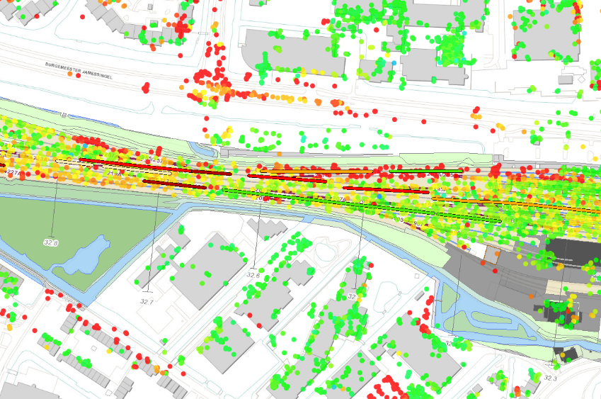
As the theoretical position of the track axis is known, deformation (rates) within the corridor of individual tracks can be analysed and compared/combined with data obtained from measurement trains. Both the vertical deformation of the track alignment in time as well as exceeding local displacements within shorter periods can then be examined.
Space Added Value
Satellite monitoring could enable a solution which provides asset managers and infrastructure owners with services that cover the total network, is non-intrusive, already has historical data available, can improve existing prediction models and does not need new data acquisition tools/equipment.
Compared to existing ground based inspections, satellite-based Earth observation (EO) data is available in a much higher frequency of every 4 to 12 days. If this EO data can be used as an additional indicator for monitoring track behaviour, this can supplement the existing methods and overcome their weaknesses.
Interferometric Satellite Aperture Radar (InSAR) techniques make use of Synthetic Aperture Radar (SAR) datasets derived from Earth observation satellites. SAR is an active microwave imaging technology that provides all-weather and cloud penetrating capabilities around the clock.
 Figure: 1. GVL data and tamping details

Figure: 2. SkyGeo data and tamping details
Current Status
For a success of the envisaged service it is a prerequisite that specific rail technical issues can be detected from satellite Earth observation data at an early stage of their occurrence. As part of a Proof of Concept, no technical correlation between satellite data and relevant in-situ events could be established.
Due to this lack of technical feasibility, a viable business case could not be elaborated and the Feasibility Study was closed.
Prime Contractor(s)
Subcontractor(s)


