Objectives of the service
Precision Farming aims to increase productivity by efficient use of resources such as soil, inputs, time, and energy. To achieve this, integration of accurate positioning and guidance, comprehensive process automation, reliable communications, weather history and forecast data, satellite data, and optimisation of planning and management processes is required.
In the agriloc feasibility study a thorough survey of the current situation and user needs has been carried out. Systems & services to address these were developed and validated with the user community.
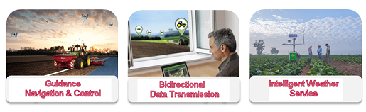
The agriloc systems & services consist of the following integrated components:
- Guidance, Navigation & Control (GNC) with highest accuracy down to a scale allowing for the treatment of individual plants
- Reliable Communications utilising communication satellites to ensure reliable and continuous transmission of RTK data for GNC, and telematics data for fleet coordination
- Intelligent Weather Service for integration of weather data in process planning, automation, and management
- Test and certification services for new Precision Farming services and systems
The agriloc study has showed that demand, technical feasibility, and benefits for the users are given.
Users and their needs
Today’s Global Navigation Satellite Systems and Guidance Solutions allow for accurate path tracking control as well as variable rate applications addressing the needs of particular zones within a field. In order to meet the customers’ increasing needs for lower input cost and higher yields, agriloc thinks accuracy even further by addressing smallest zones down to individual plants.
At present, there is no integrated service available that provides short-term weather predictions (e.g. based on infrared EO) for planning of farming activities. This will become of essence within an automated environment.
In addition, despite a growing number of terrestrial communication networks, users report lack of communication in the field in order to obtain the corrections required for precise positioning. Space-aided services assist the operators of tractors and other field machinery to precisely plant, fertilise, spray, or weed with sustainable savings. The services allow optimising the complex processes of agricultural operations (such as harvest) by networking with all participants of the supply-chain in real-time via Satcom to exchange e.g. information on vehicle positions, work progress, yield, and weather information.
TARGET USERS
Targeted users are arable farmers, their directly linked contractors, and machinery rings.
Target demonstrations could take place in Germany but agriloc targets to provide services in whole Europe.
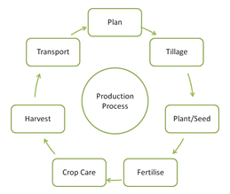
Service/ system concept
Today’s agricultural farming faces the challenge of feeding a growing world population from a decreasing area of arable land per capita. The main challenge is the increasing multi-domain knowledge required to operate a farm efficiently and successfully. A farmer needs to have good understanding in agricultural practice, in weather interpretation, in mechanical and electrical engineering, logistics, management, finance, legal regulation and last but not least on environmental impact.
To support farmers in their daily work, Farm Management Information Systems (FMIS) will have to provide not only the relevant information but also decision support.
Basically the agriloc services consists of five services and their inter-relationships;
- Guidance, Navigation & Control Services
- Satellite Communication Service
- Intelligent Weather and Satellite Data Service
- Testing & Certification
As shown schematically in the following picture.

The sketch displays the relationship between the user in the centre, the agriloc services and the environment. All five services complement each other to support and improve precision farming processes.
Space Added Value
Precision Farming relies on Global Navigation Satellite Systems (GNSS) and associated satellite based wide-area Differential GNNS. Earth Observation satellites provide further data for large areas necessary for example for mapping and bio-mass monitoring saving time and money. Satellite Communications provide the highly-reliable and globally available medium for continuous automated Precision Farming processes such as planning, fleet management, synchronisation of machinery, and transmission of satellite navigation correction messages.
Current Status
The agriloc feasibility study has been finished following the Final Review in December 2014.
In the feasibility study market gaps and customer needs have been identified, proposed agriloc services have been validated with end users, and technical feasibility, sustainability, and benefits of the services have been validated.