Objectives of the service
The main objective of the AGRO-BIOMES business idea is to support biodiversity increase in agricultural ecosystems, providing robust and easy-to-use analytics and tools.
A variety of data formats are essential for fully comprehending and protecting biodiversity. Nonetheless, there are still certain restrictions and data gaps in the study and conservation of biodiversity. The identified market need in this area is to find robust and easy-to-use tools/certificates that can be used in agricultural landscapes for evaluating and monitoring biodiversity. Earth observation (EO) data and remote sensing (RS) meet this need by offering standardized, large-scale, scalable, and almost real-time information. Additionally, EO and RS provide the rare opportunity to give information at Time 0 and to provide monitoring capabilities over time, thereby enabling evolution assessment. The final proposed service will systematically map and monitor farm habitats, identify agroecological infrastructures, and support pollinators/connectivity.
Users and their needs
The project's main target audiences include the regulatory market, private initiatives (e.g. quality labels, green finance), and public policies supporting payment for ecosystem services.
Through the AGRO-BIOMES kickstart activity, EDAgro collaborated with companies in the digital ag, commodity, consultancy, and fintech markets.
The end users involved in the kickstart activity have expressed a lack of reliable solutions for evaluating and monitoring biodiversity in agriculture. Their needs are as follows: (i) need a tool to measure biodiversity at field level. (ii) need in measuring the agro-ecological infrastructures and in aggregating the results at farm level. (iii) need in integrating biodiversity analytics into their operational framework which may not be all digital. Ultimately, all those end users expressed their interest to utilise a final solution that would be global, reliable, robust, and scalable at international scale.
Service/ system concept
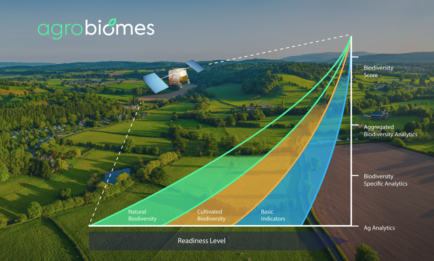
For efficient evaluation and monitoring of biodiversity, the user is provided with three types of indicators: basic indicators, indicators of the cultivated biodiversity, and indicators of natural biodiversity that will enable tracking of biodiversity through a biodiversity score.
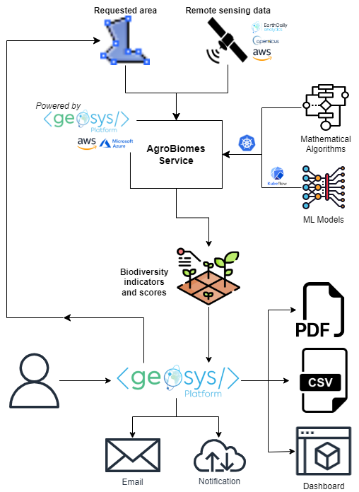
The proposed workflow aims to characterize biodiversity within a farm by following several steps that rely on existing algorithms and require innovative developments. The service will be fully integrated into the global EDAgro system architecture, specifically the <geosys/> platform, as an analytic processor.
The system architecture is as described hereunder.
Space Added Value
The AGRO-BIOMES kickstart activity intensively relies on the Copernicus earth observation satellite (Sentinel-3, Sentinel-2, Sentinel-1) as input images to segment the farm into different homogenous units. Indeed, medium resolution optical imagery is critical to produce spectro-temporal signatures of these homogeneous units. Radar can also be envisaged to complete optical imagery when considering homogeneous units’ definition and infrastructure detection (e.g., for hedgerows).
Furthermore, the Copernicus program’s added value is its high revisit time and its global coverage that allows on one hand to intensively monitor hotspots of biodiversity changes, which won’t be feasible with human resources on the ground (or for much higher costs) and on the other hand to monitor numerous places at the same time (also linked to time and human resources), as well as spots that wouldn’t be easy to access by ground means.
Ultimately, the use of an independent observation to access quantitative measurements of specific biodiversity indicators is of particular interest to assess independently the performance of growers and farmers in terms of cultural practices/ land use management over time.
Current Status
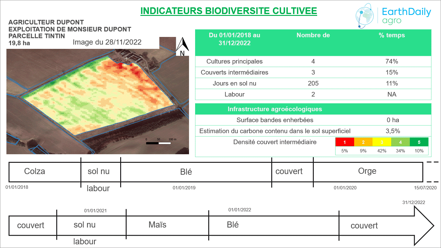
As to now, questionnaires and workshops have been carried out with potential customers who have also been proposed the above mock-up as a possible user interface to assess and evaluate biodiversity at field and farm level (a picture of this mock up is given above). Feedback has been largely positive. A few of these indicators have been tested and validated based on ground truth in France.
Analytics integration into the <geosys/> platform architecture has also been created and IT/DEV/MLOps effort has been evaluated.
Finally, market analysis, product pricing and a business plan have been elaborated.
Currently, EDAgro envisions to continue developing a final product/ service related in biodiversity monitoring and evaluation in agriculture landscape and intends to apply to additional fundings to do so.
Prime Contractor(s)