Objectives of the service
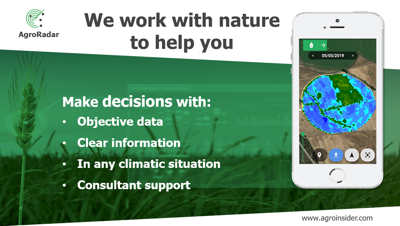
With the AgroRadar solution farmers can optimise their soil-water-plant relationships and create food that respect Sustainable Development Goals.
Users and their needs
The solution serves farmers, whatever their size or crop, who need reliable and on time information in order to improve their processes. Among other things, one can help anyone who wants to:
- Identify and study soil characteristics with radar satellites
- Do smart sampling (soil, plants, water, carbon…) for better inputs optimization
- Detect in real time crop anomalies and being notified by means of an alert system
- Improve their economic and environmental footprints
The solution was improved and demonstrated in different crops, in 5 countries in different climates: Portugal, Spain, Brazil, Guatemala, El Salvador, Nicaragua and Mozambique.
Service/ system concept
When the service is deployed the user is able to delineate management zones in terms of: weeds, soil fertility, plant density, plant nutrition, plant health, plant water stress management and food quality. It will also be able to delineate soil, plant, food and carbon smart sampling, registering all the production processes with the developed traceability tools (coordinates, text, documents, images…) in order to have transparent production processes and systems.
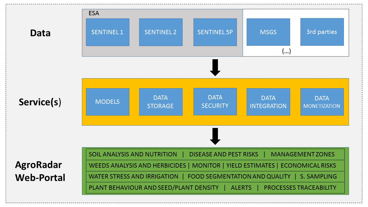
The system works considering Copernicus (Sentinel 1, 2 and 5P), meteorological 2nd generation satellites (MSGS) and 3rd parties’ data integration. With this particular data several processes and models are used in order to produce agronomic outcomes (intelligence) with value for decision. At the same time the infrastructure integrates, stores and secure all the user data
Space Added Value
Sentinel 2 is the most used satellite when it comes to agricultural applications, however, such use is limited when clouds are present. In the absence of clouds, this type of satellite is widely used in the management of plant nutrition and in the analysis and detection of anomalies associated with soil / water / plant relationships. The areas of the world with great relevance in food production normally present a very strong cloud dynamics, preventing the systematic use of Sentinel 2.
In view of the above, a serious research investment was made in Sentinel 1 in order to overcome the difficulties mentioned above with Sentinel 2. Sentinel 1 has great potential in the study of soil quality and soil fertility, as well as measuring plant structure anomalies and estimating Agro – Forestry
production.
The integration between both satellites provides a big data infrastructure that allows crop inspection and crop optimization in any climate conditions.
Current Status
Agroradar + Agriculture + Climate neutrality + Green Deal
With Agroradar technology any farmer can be “Farm to Fork” Compliant because Agroradar solution can optimize agronomic, economic and environmental processes at a parcel scale. Soil-Water-Plant relationships are audit and the best production practices can be implemented prior, during and after crop campaigns.
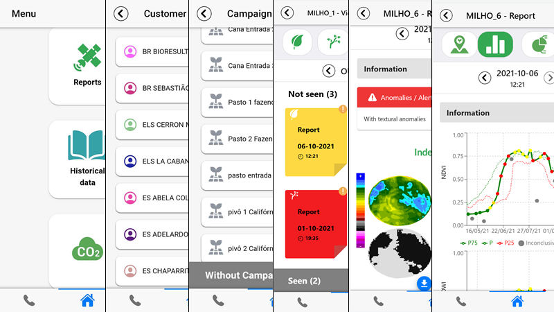
Prior: Before starting a campaign in a specific parcel, historical data could be compiled and analyzed according Agroradar algorithms and reports (Figure 1). Crop/parcel historical behaviors can be studied and produce insights about crop management zones, smart sampling, smart nutrition and differential management.
During: After implementing prior decisions AgroRadar algorithms will scan parcels for specific crop anomalies during all campaign. Those anomalies can be classified in 3 levels (green, yellow, red). A red level obliges the farmer to a field inspection (problems: irrigation machinery; pests and diseases; drainage; nutrition; soil-water-plant relationships, etc.)
After: After a campaign another AgroRadar reports (Figure 1) will be produced and analyzed in order to prepare the next campaign considering the detected crop/parcel anomalies and the agroeconomic results.
All the data (evidences) produced during campaigns is block-chained and shared to partners and clients in order to create transparent production systems and create food value chain trust.
Prime Contractor(s)