

Objectives of the service
With a long experience, rooted in 15 years of research and proprietary crop data models, AgroInsider provides large-scale Precision Agriculture (PA) services to farmers, agronomists and companies. We are able to provide greater sustainability, higher productivity and lower costs for farmers, by using big data analysis, including Earth Observation data, proprietary algorithms and agronomic data models. We provide tailor-made reports to farmers, which enable plant water and fertilizers optimization and harvest yield forecasts.
We have identified that satellite optical data, currently being used by the best PA companies around the world, is not enough to obtain the best results. So, we have developed our proprietary AgroRadar algorithms that process Copernicus EO Synthetic Aperture Radar data, which has the advantage, when compared to other remote sensing technologies, to be available in good and bad weather conditions, giving us the ability to obtain more precise and detailed agronomic information in cloudy geographies where normally agriculture has a great importance.
Our customers have experienced an increase of 15%-30% on production. With the current project we have enhanced our algorithms from processing Earth Observation Data, integrated other 3rd-party data and validated our platform with pilots in different geographies. The main goal was to create the basis to ensure our product market debut, with a clear and scalable commercialization strategy.
Users and their needs
The solution developed targets four main users, each one with their specific needs:
1. Farm Producers (small and medium):
- Access to low-cost PA services to obtain new insights for:
- reduction of operational costs up to 20% (fertilization, water usage);
- timely mitigation of farming hazards (5-day reports to detect anomalies in growth, diseases, leaks, etc.);
2. Farm Producers (large):
- Improved PA services including large scale management of assets (at inter-continental level if needed);
- Reports that are not affected by environmental conditions;
- Reduction of operational costs up to 20% (fertilization, water usage);
- Forecast and optimize crop yield;
- Improve net margins.
3. Agricultural Professional Organizations and Farmers' Associations:
- Better tool for production costs’ reduction, production forecast and optimization to ensure the compliance of the ongoing contracts;
- Improve individual and global net margins considering crop specialization by associate;
4. Other Interested Third-parties
- Improved and tailored made PA services with more information to improve their own business;
- Complemented services to improve their own products/services portfolio;
- Updated and detailed geospatial information on insured assets (agriculture, forest, etc.);
- Improved fraud detection;
- Surveillance and inspection.
Service/ system concept
The disruptive AgroInsider solution is based on the big data provided by the Copernicus program (Sentinel 1 and 2). This solution was not possible to develop until very recently due to low satellite temporal (and spatial) resolution. In agriculture, the validity of decision-making usually has a life expectancy of around 5 to 7 days, adjusting perfectly to the temporal resolution of Sentinel 1 and 2 of the Copernicus Program.
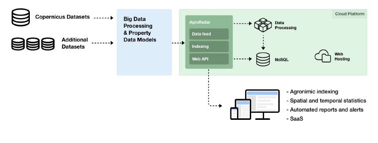
Customer interaction with the platform is done from a front office with a set of configuration menus that help the customer on how to organize the parcels and crops into coherent geographic units. The client can have an overview of all its contracted parcels and indexes (Sentinel 1: RI1, RI2 and RI3, Sentinel 2: NDVI and NDWI). The manual observation is done by switching the indexes and the relevant dates to observe and analyse the monitored crops.
Space Added Value
AgroInsider is developing disruptive high added-value solutions for PA based on Copernicus EarthObservation data, using two types of Copernicus satellites data:
- Sentinel 1A/1B (SAR sensors);
- Sentinel 2A/2B (Optical sensors) with world coverage.
The images for these satellites are downloaded automatically from the Copernicus science hub considering the parcels localization (monitored all over the world). Sentinel 1 are normally used to study soil texture in order to execute soil smart sampling and Sentinel 2 are used to monitor chlorophyll and leaf water content. Spatial and temporal resolutions rounds approximately 10m and 5 days for both satellites. From all these space data we model agronomically each parcel/crop with proprietary agronomic models and at the same time produces a large data set of non space data, normally associated with the characteristics of each parcel/image that is stored for further processing with artificial intelligence techniques.
With the current data provided by the Copernicus program, AgroInsider develops applied research with its clients in order to define crop reference values for radar and optical indexes. With these AgroInsider and its technology, we build different value added outcomes and services that enable customers production optimization and early warning system associated with particular parameters.
Current Status
The ESA Kick-Start AgroRadar project started 1st July 2018, with closure date at 30th December 2018.
For the implementation of AgroRadar we have designed and performed proof of concept (pilots) in different geographies, and targeting different crops. This approach was design in order to better understand and measure the customer perception of AgroRadar value proposition, the value for money and the actual product impact for different crops and geographies.
Thus, the pilot companies were selected based on their dimension, geographic dispersion and crops for a wider testing of AgroRadar potential, allowing the collection of significant insights to attest the market replicability and scale-up potential of the product. Two type of pilots were executed during this project:
- 2 pilots in Portugal: due to its proximity, enabling us to test in a more deep analysis any new feature deployed in the project and collect customer feedback to improve AgroRadar.
- 2 pilots in different target geographical segments, Guatemala and El Salvador: enabling us to test in a second release stage our product features in different crops, geography, language, satellite coverage and any other aspect that comes from testing our product in a different cultural environment.
The main activities implemented in each proof of concept include the setup, coordination and operation of the pilot - in articulation with the different pilot stakeholders - and the measurement of the product performance in operational environment, with the goal of fine-tuning AgroRadar platform and estimating the impact of AgroRadar on the customer costs structure and overall productivity.
A list of customer requirements and other feedback provided, together with the results of the technical developments performed, were the based for the development of new features to be implemented on AgroRadar platform.
Prime Contractor(s)

Status Date
Updated: 07 June 2019