Objectives of the service
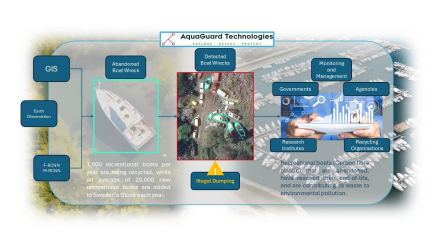
AquaGuard Technologies is developing a Geographic Information System (GIS) software solution for geospatial analysis using high-resolution satellite imagery (e.g. WorldView series) and advanced AI techniques such as Faster Region Convolutional Neural Network (F-RCNN) and Mask Region-based Convolutional Neural Network (M-RCNN). This technology enables the precise detection and classification of abandoned boat wrecks among recreational vessels, addressing critical environmental challenges such as illegal dumping. AquaGuard Technologies service serves governments, agencies, research institutes, and recycling organisations as potential customers in monitoring and mitigating marine pollution.
The service is built around the below key objectives:
Real-time Detection & Visualization: Identifying and mapping abandoned boat wrecks on land and water across Sweden, providing geospatial insights on their location, quantity, and distribution.
Reliable Data Management: Establishing a software platform for tracking imported, exported, end-of-life (EOL), and abandoned boats, supporting real-time decision-making.
Comprehensive Marine Incident Response: Enabling early detection and rapid response to environmental threats such as abandoned hazardous waste.
Users and their needs
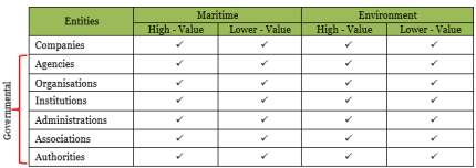
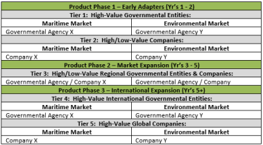
There are seven key customer/user segments targeted for this project which are identified and listed in the following table below. As described in the detailed project proposal [ESA-CfP/SRES-Sweden/19790513] there are two industrial focal areas of interest to us, namely the “Maritime industry” and the “Environmental recycling industry” from which our key customer/user segments are derived.
The SaaS product to market development is split into 3 main phases of customer/user acquisition from early adapter phase 1 to international expansion phase 3. Within these 3 phases of product development our customers/users have a tiered-level approach ranging from Tier-1 to Tier-5 which is dependant on their level of significance within each phase of the development.
General overview of Customer/User needs:
-
A new revised and novel method of accurately detecting, mapping and recording of abandoned recreational boat wrecks, vehicles and other. Current methods of mapping are outdated, inefficient, costly and time consuming both from governmental and company levels
-
Currently no mapping software exists, and reliability of such data exists only through word of mouth or local marinas connected to recycling agents
-
Limited visibility into the location and status of abandoned vessels makes it difficult to track progress and ensure compliance with environmental regulations
-
A dedicated system with reliable updated information that will aid with the enforcement of regulations which are currently difficult due to lack of transparency with such environmental pollution • Locating abandoned boats/vehicles/other, suitable for recycling can be challenging and time-consuming. We currently have no in-house geospatial intelligence for such detections or to aid monitoring/mapping
Service/ system concept
The service consists of several value layers, each supported by specific technologies:
User Interaction: Users submit requests through a secure user interface, specifying their area of interest and the type of application (e.g., detecting abandoned boat wrecks).
Data Ingestion & Retrieval: The system checks the existing database for relevant satellite data. If no suitable data is found, it retrieves corresponding Earth observation data from external sources.
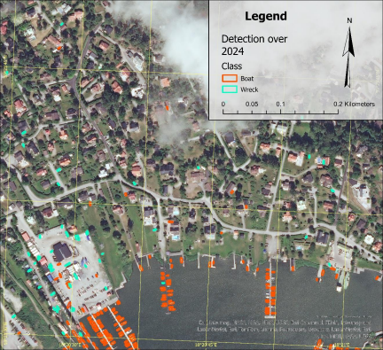
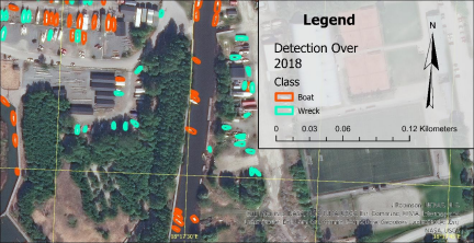
Pre-processing & Analysis: Once the data is acquired, it undergoes pre-processing before being sent for processing. The system leverages pre-trained machine learning models [*] to detect the requested objects (e.g., Abandoned Derelict Wrecks (ADV’s).
Output Generation & Quality Assurance: The processed data is used to generate multiple outputs, ensuring quality assurance. These outputs are then formatted for presentation through an application layer.
Customization & Delivery: The final outputs can be customized and/or delivered to users via the secure user interface.
AquaGuard Technologies uses training data to train, validate and fine-tune machine learning models for each specific application (e.g. detecting abandoned boat wrecks). This forms the core of the system, enabling it to accurately distinguish abandoned boat wrecks from other objects, particularly normal recreational boats.
Space Added Value
The current methods of detecting, tracking and monitoring abandoned boat wrecks that are considered an environmental hazard are primitive and involve the gathering of information through surveys, searching historical transport agency data, interviews, word of mouth and conducting questionnaires. This information is compiled into large documents with guesstimated figures on the number, type, location, dispersion and size of such boat wrecks. AquaGuard Technologies utilises advanced technology to carryout the same process, rapidly and securely to ensure our customers receive accurate, reliable and factual information in near to real time.
AquaGuard Technologies uses Earth Observation data, especially high-resolution optical satellite imagery, for training our own machine learning models (we use our own software code) to detect abandoned hazardous waste. New satellite images are also used to monitor customers area of interests, identifying abandoned boat wrecks and distinguishing them from recreational boats. Satellite imagery is a powerful tool for large-scale environmental monitoring, providing unmatched scalability and global coverage, especially when compared to localized technologies such as drones, manned aircraft, and sonar/ROVs. Using our own developed software AI/ML code for detection, tracking and monitoring of such activities, we aim to overcome the current obsolete methods of carrying out such work in near to real time.
Current Status
AquaGuard Technologies have now successfully concluded our 6-month ESA-BASS kick-start project, and with our company incubated under the ESA-BIC 2-year program with are now progressing on furthering our software development as an MVP for market demonstration. This ESA-BASS kick-start allowed us to develop our own deep-learning, AI integrated, algorithms and code in addition to developing of system architecture for dissemination of information to satisfy our customer/user needs as briefly described above.
Upon successful completion of our assessments regarding the desirability of our service, the technical feasibility
carried out and the economic viability case which shows very promising results with a sustainable future, we are now ready for furthering the development of this product to market.