Objectives of the service
AirTracks is a flexible and cost-efficient Air Navigation Information Service (FIS) for small and medium airports and airfields. It aims to enhanced airport and aircraft safety during approach and departure. Airtracks integrates aircraft surveillance information such as ADS-B, Mode-S obtained in the vicinity of the airfield as well as meteorological information, eNOTAMS or flight plan information. The fused information is visualized on web-based display, showing the relevant ancillary information layers in a user-friendly way.
AirTracks offers:
-
Precise visual information of approaching and departing air traffic
-
an enhanced air and ground situational picture
-
Better planning and coordination of all aircraft traffic
-
Enhanced safety for airmen, airport and surrounding population
Users and their needs
Customers targeted by the AirTracks service are small and medium airports and airfield operators, operating so called uncontrolled airfields. Those airports are usually used by General Aviation aircraft, e.g. business jets or leisure aircrafts, but have neither their own surveillance technology such as primary or secondary radar, nor access to the associated information. Approach and departure procedures are exchanged only via voice communication, which limits the level of safety that be offered to air traffic.
Aerodrome operators are therefore very interested in a more comprehensive situational awareness picture from a reliable single source of data.
Service/ system concept
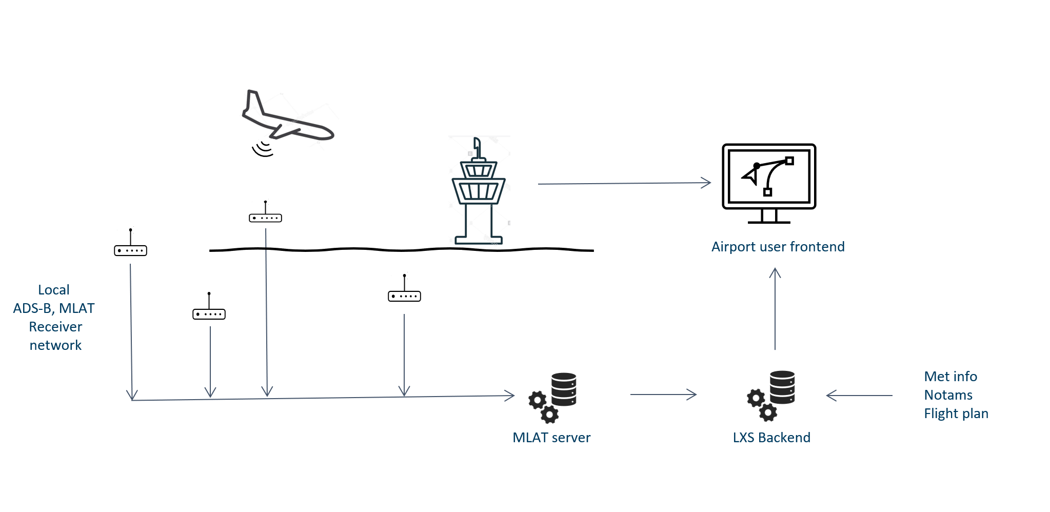
The main components of the AirTracks Flight Information Service (FIS) for Small and Medium Airports are as follows:
-
Data reception:
-
Aircraft tracking information based on ADS-B and Mode-S transponders
-
Ancillary data, such as meteorological information,
-
-
Data fusion/management:
-
All data sources are fused and stored at the AirTracks data centre and configured individually for Small and Medium Airport client/customer
-
-
Data submission and visualisation:
-
Data are made available via a webservice, i.e. data remain at the AirTracks data centre
-
Data are visualised (“recognised aeronautical situation”) on screen at customer premises, including any notification/alerting
-
Space Added Value
The service offering for Small and Medium Airports is based around two space assets:
-
Satellite Navigation is used to determine aircraft positions via ADS-B messages. This information is the baseline to create situational awareness for responsible Air Traffic Services personnel. In addition, this satellite-based information allows to track aircraft positions during approach, landing and on the airfield without the need of massive infrastructural investments for airports.
-
Earth observation information is used to provide airport specific professional meteorological services. Optical Earth observation imagery can be provided as an additional on demand service to requesting airports. The space technology in use allows to generate a suitable FIS tailored to the need of small and medium sized airports.
Current Status
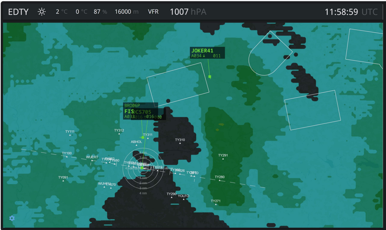
The AirTracks demonstration project was successfully concluded in December 2023. The added value of the service was confirmed by the controllers at the Wuerth Airport tower (AFIS officers), who had a very close look to the system from an operational point of view. The expected functionalities of the entire AirTracks end-to-end system fully met the user requirements. Key features include 1) accurate aircraft positions and tracks using ADS-B and Mode-S multilateration, 2) visualisation of aircraft movements in real time on a web based graphical display, 3) additional weather data overlay and 4) a 3D replay function of past tracks for reinforcing flight rules and compliance control.
As such the Airtracks Air Navigation Service did demonstrate its added value to improve air traffic safety and security in uncontrolled airspaces.
After the necessary certification of the Air Navigation by the competent authorities, it is envisaged to commercialise the service throughout Europe.