

Objectives of the service
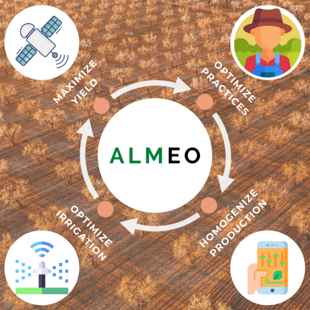
Global consumption of almonds has doubled over the last decade and significant growth in demand has been observed in both developing and mature markets. To maximize yield and optimize fruit quality, the main challenges for almond growers are to optimize irrigation and the use of phytosanitary treatments. AlmEO’s objective is to provide high added-value products namely 1) crop growth monitoring and 2) irrigation recommendations to support almond growers in managing their orchards, maximise yield and improve almond quality thus saving water, energy and time.
The Sentinel-2 satellite time-series allows orchard vegetation development monitoring throughout the growing season and spots any abnormalities that may require corrective action on the ground. The integration of weather data, soil characteristics and crop information using satellite imagery enables water requirements to be calculated at plot level on a daily basis and provides guidelines for irrigation.
The results are accessible via a user-friendly web platform and mobile application. Alerts (email/SMS) are generated and sent automatically to users in case of abnormal vegetation development or when plots require irrigation.
Users and their needs
The main users of AlmEO are almond producers (ranging from small farmers to agro-industrial companies and agricultural cooperatives) or local technical advisors. Several entities from Europe and South America have participated in the AlmEO project the needs and requirements of whom have been collected and consolidated.
All main users face risks of water stress and abnormal variations in the vegetation development of their almond crop potentially leading to a significant loss in production and a reduction in quality. Their main needs are therefore to monitor vegetation growth and water requirements in the orchards to better adapt agricultural practises in near-real time.
The needs expressed by potential customers can be summarized as follows:
-
Detect growth deviation problems that could have an impact on the quality of almonds,
-
More rational use of water resources to irrigate only when it is needed and with the right amount,
-
Less time spent on field visits,
-
Complement existing knowledge and data to make better and cost/time effective decisions,
-
Increase crop homogeneity over time to secure yield and almond quality.
In order to cater for these needs, the main challenge is to develop well-adapted and simple indicators that bring direct added value and assist the almond producers in the day-to-day management of their orchards.
Service/ system concept
The AlmEO service consists of two complementary tools developed by TerraNIS: Vegetation Growth Monitoring and Daily Water Status.
The Vegetation Growth Monitoring tool provides maps of vegetation development and statistical indicators which allow early identification of abnormal behaviour of different plots (heterogeneity or average development levels) in order to implement corrective actions on the ground if necessary.
The Daily Water Status tool provides an estimation of water requirements and irrigation recommendations at plot level. The graphic interface enables daily monitoring of the status of the water available in the soil with a 7-day forecast. An alert is sent via SMS or email with irrigation recommendations. The water consumption is thus optimized through improved irrigation management practices.
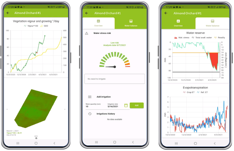
Both tools use satellite images which are automatically processed online using in-house algorithms (vegetation development calculation and water balance model), weather data and in-situ data provided by end-users (plot locations, soil types, farming practices). The final products can be easily visualised on a mobile application via a graphic user interface.
Most of the current solutions available for vegetation development monitoring use classical vegetation indexes (i.e. NDVI), which are not crop-specific. With the AlmEO service, the state of the crop is assessed by calculating a biophysical parameter that provides an accurate indication of the photosynthetic activity of the vegetation. This parameter has proven its robustness, especially for heterogeneous crops such as almond orchards.
Space Added Value
Satellite imagery is at the heart of the AlmEO service. The two complementary tools are based on the use of Sentinel-2 satellite data. Due to their recurrence (1 image every 5 days without cloud coverage), spectral characteristics, high spatial resolution and free availability, Sentinel-2 data are of major interest in vegetation monitoring both at farm and plot level.
Current Status
This Kick-start activity has been concluded successfully. User needs (expressed from entities located both in Europe and South America) were successfully collected (online survey, phone calls and visits) and consolidated to define the service requirements.
The technical feasibility of all the fundamental building blocks which constitute the architecture of the system was examined.
The commercial viability of the proposed service was analysed and a business plan demonstrating the sustainability of the service was provided.
Before entering the commercialization phase of AlmEO service, a follow-up Demonstration Project is necessary to implement all the requirements which have not yet been met, in particular those regarding the Daily Water Status tool which requires further development. At present many potential stakeholders of AlmEO have expressed their interest in participating in this potential follow-up activity.