
Objectives of the service
The key problem users face is the manual recalibration burden of existing irrigation models like Geisenheim and FAO-56. These models lose accuracy over time, leading to inefficient irrigation practices. Autocali provides an automated recalibration solution by analyzing satellite images for soil moisture signals and adjusting the models accordingly. This eliminates the need for manual recalibration and makes it easier for practitioners, especially in low-income countries, to maintain accurate irrigation schedules. The objectives of the service are to increase the acceptance of deficit-based irrigation models, improve their accuracy over time, and explore licensing opportunities. The activity focuses on a feasibility study to develop technical approaches for automated recalibration, including satellite image analysis and user involvement. By gathering ground truth information, Autocali aims to continuously enhance the accuracy of irrigation recommendations. The ultimate goal is to offer a reliable, cost-effective, and user-friendly solution for optimizing irrigation practices and conserving water resources.
Users and their needs
The target user groups for Autocali are vegetable farmers and root crop farmers, primarily in Germany, Italy, and Spain. These users have specific needs and challenges that Autocali aims to address. The key user needs include:
-
Time-saving in irrigation planning, coordination, and monitoring
-
Increased crop yields
-
Efficient and water-saving practices, particularly in dry areas
-
Prevention of crop losses due to inadequate irrigation
-
Cost savings on energy expenses
Service/ system concept
To meet these needs, Autocali focuses on automating the recalibration process of irrigation models. By analyzing satellite images for soil moisture signals, the system provides accurate and timely irrigation recommendations, eliminating the manual burden for users. This saves them valuable time and allows for efficient irrigation planning and coordination.
The project also aims to improve crop yields by ensuring accurate irrigation schedules, preventing under- or over-irrigation. By optimizing water usage in dry regions, Autocali helps farmers mitigate the risk of crop losses and reduces energy costs associated with irrigation.
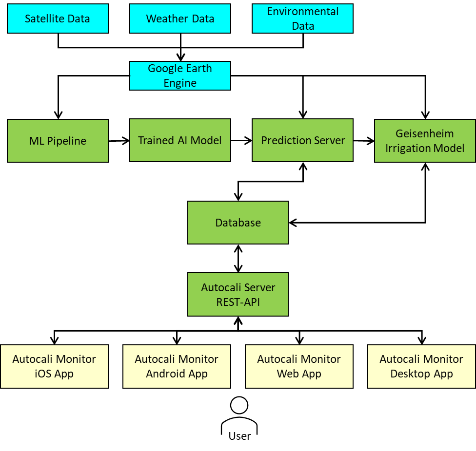
The system architecture is cloud-based and includes several building blocks. These include the Google Earth Engine for storing geospatial datasets, the ML-Pipeline for data processing, an AI-Model for predicting soil moisture content, a prediction server for scalable predictions, the Geisenheim Irrigation Model for soil moisture changes calculation, a database for storing user input and predicted data, and an Autocali Server for business logic and user access.
Space Added Value
The additional value provided by satellite data is that farmers no longer need to invest in expensive field sensors or manually input and adjust data. Instead, satellite data enables irrigation recommendations to be given regardless of location, resulting in resource savings that would otherwise be allocated to field inspections and sensor hardware.
In the project, primarily microwave satellite data (Sentinel-1), multispectral satellite data (Sentinel-2), and thermal satellite data (Sentinel-3) are utilized.
Current Status
The project is currently in an advanced stage. The user needs of the target communities have been validated through over 50 interviews and further verified at various exhibitions and trade shows. The initial technical concept has been fully developed and translated into a functional prototype.