Objectives of the service
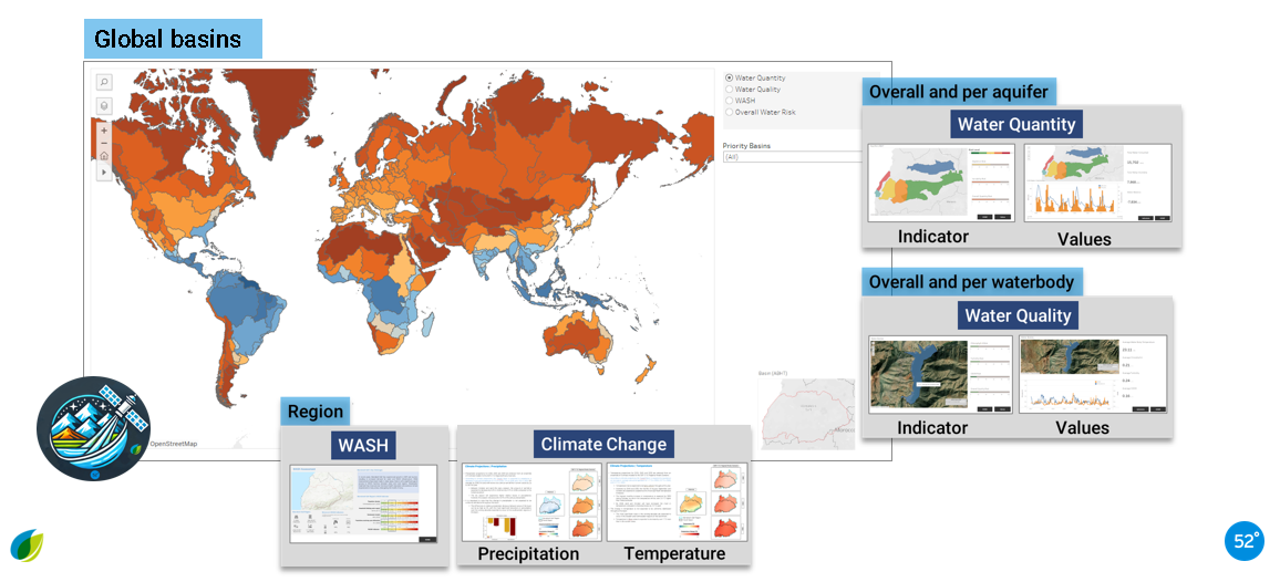
eLEAF and partner 52impact are overcoming the challenge of obtaining accurate and relevant water-risk related data with ‘BasinMeter’. The project combines scalable Earth observation technology with local datasets to expose the vulnerability of local watersheds and the impact on local related agricultural production and the community WASH (Water, Sanitation and Hygiene). The project will enhance both strategic decision making and direct local intervention to mitigate water-stress for both companies as well as local communities are heavily relying on water. To do this, it is no longer valid to depend (only) on historical data but requires a closer monitoring through scalable Earth Observation methodology as delivered by eLEAF and partner 52impact for the Net Positive Water Impact (NPWI) indicators that contribute towards reducing water stress in its three dimensions: availability (quantity), quality, and WASH.

Users and their needs
ESA is working with eLEAF through the ESA Business Applications and Space Solutions programme, under the ‘Digitising Water Resilience Monitoring in Basins’ initiative, in partnership with the CEO Water Mandate’s Water Resilience Coalition (WRC). BasinMeter has been announced in the first batch of Feasibility Studies selected under the initiative which will support companies who are developing water resilience monitoring capabilities.
Providing unbiased data and methods:
-
Scalable data and methods for quantity to measure NPWI water indicators in basins globally
-
Quantity, Quality, WASH
-
Long-term and near real-time water risks using satellite data and advanced data technologies.
-
Ranging from basin, sub basin, irrigation scheme to crop field and related commodities
-
Deep-dive into 1 or 2 basins for global feasibility
-
Climate projections for the next 30 years
Providing dashboards:
-
Multiple ways how to effectively communicate relevant water information.
-
Deliver and visualize data for the Water Action Hub from the CEO Water Mandate
-
Identify how corporate users would like to interact with the BasinMeter dashboard and customize accordingly
Service/ system concept
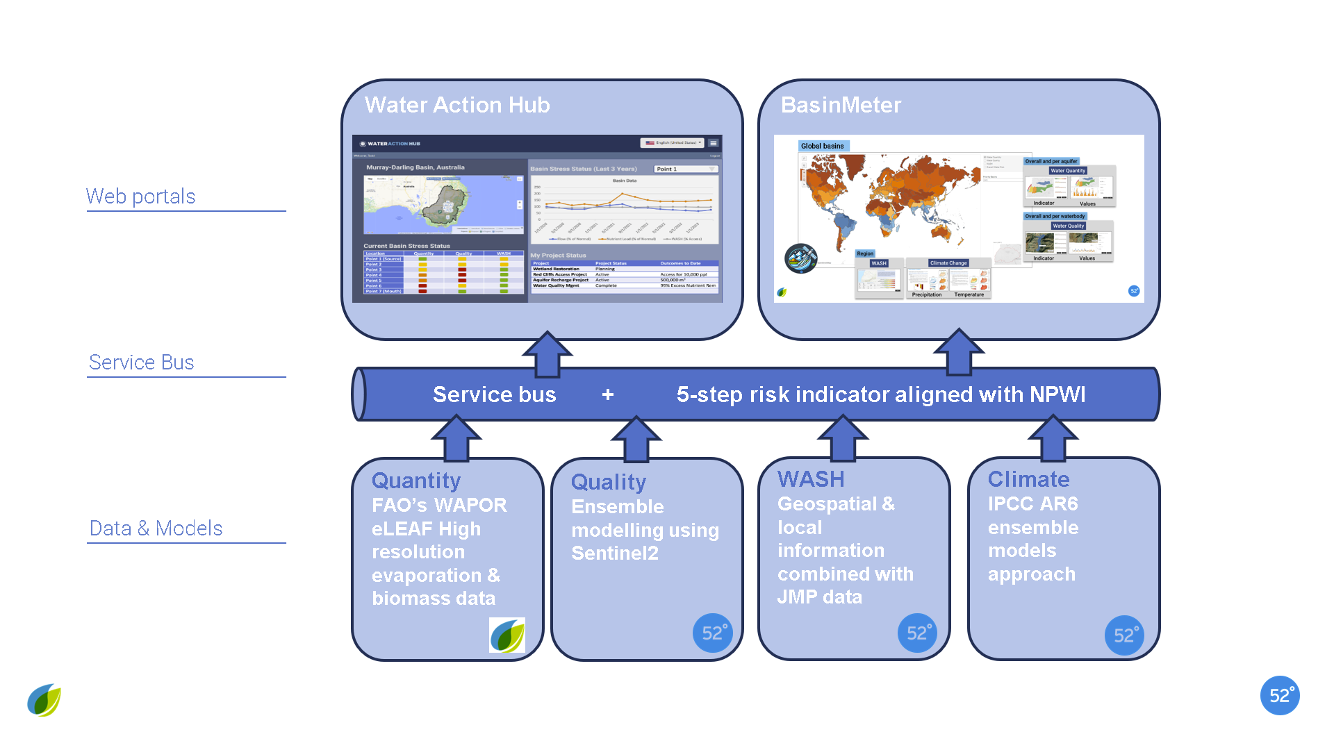
eLEAF and 52 impact can deliver their datasets in the BasinMeter dashboard or directly through FTP to Pacific Institutes Water Action Hub
Space Added Value
The following geospatial and earth observation datasets are used:
Water quantity based on validated FAO’s open WaPOR dataset (by eLEAF) and ETLook data (by eLEAF too).
Water quality based on proprietary ensemble models using Sentinel2 data:
-
Qualitative approach without local data
-
Quantitative approach with in-situ information
WASH based on geospatial & local information combined with JMP data.
Climate change insights derived from IPCC AR6 models (ensemble approach).
Current Status
Status of the project:
-
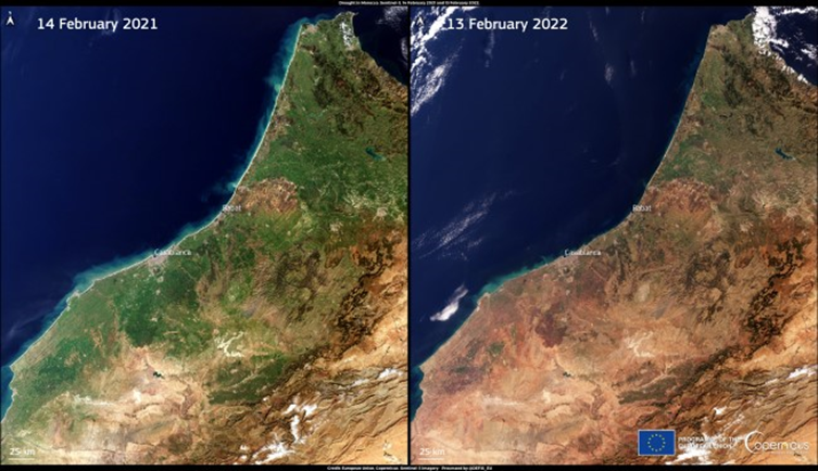
Project Basinmeter tested in Tensift Basin Meter Morocco; status monitored of citrus and olive plantations
-
Corporate clients engaged in Basinmeter: Coca-Cola Europe (Southern Spain Basin) and Jaguar Fruit company (Egypt basin)
-
Workshop held on May 16th at Dutch embassy in Egypt with more than 60 participants
-
Two workshops held with corporates from CEO Water Mandate
-
Products can be delivered world wide
-
Stockholm World Water Week panel session (ID 11401)
-
Leveraging current projects in priority basins in a.o. Egypt and South Africa
Conclusions of the BasinMeter project:
-
We start in August 2024 a project with Coca-Cola Europe and their partner Ailimpo on montoring water stress in citrus plantations in the Sugara basin in Spain
-
We can deliver world wide data and risk indicators on Quantity, Quality, WASH and Climate Projections.
-
Data pipelines are automated for Quantity and Climate projections and partially automated and replicable when it comes to Quality and WASH where ground data is needed
-
With Pacific Institute we will have follow up discussions on the use of the data in their Water Action Hub
Prime Contractor(s)
Subcontractor(s)


