Objectives of the service
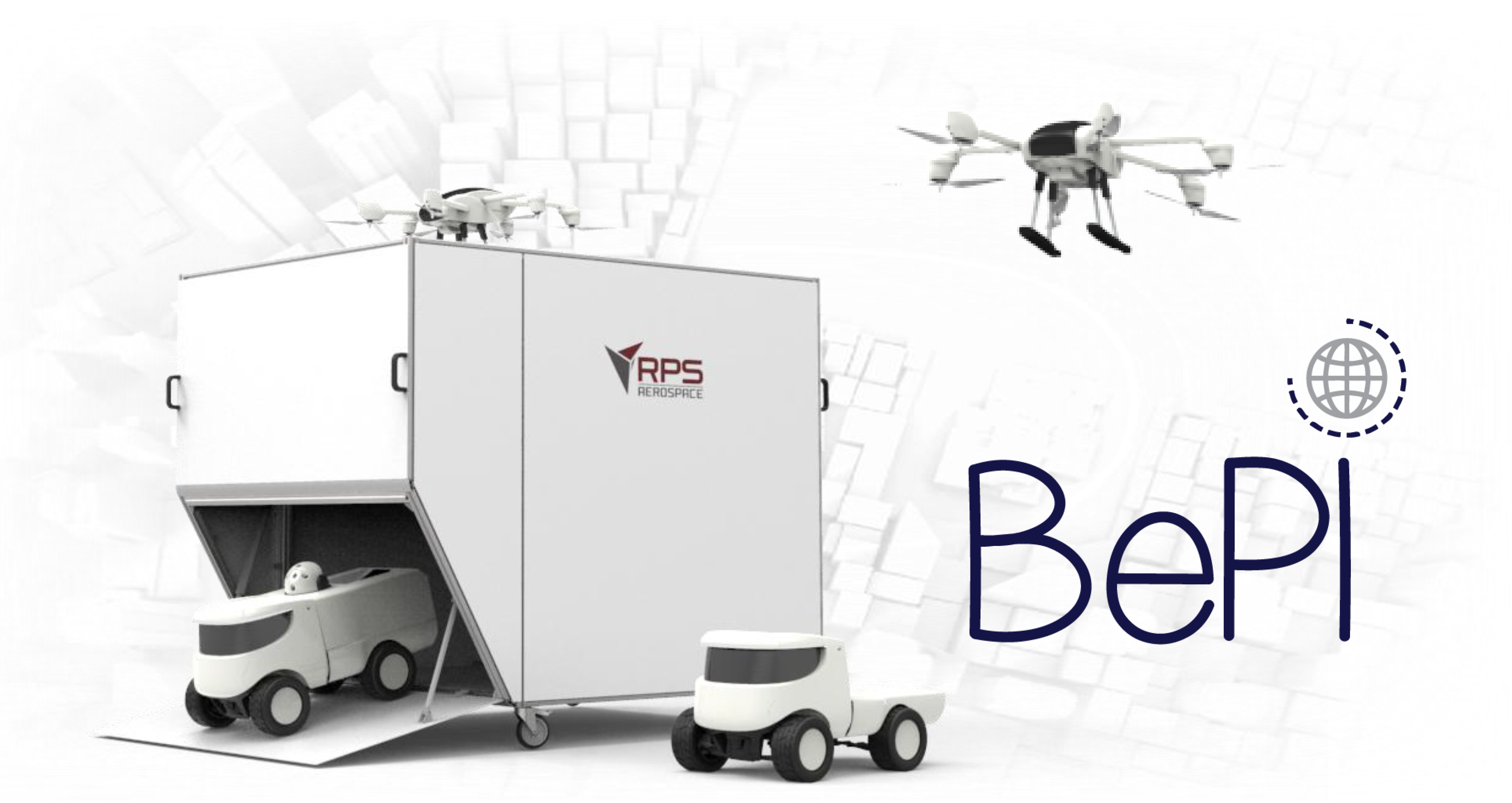
BePI is a complete and flexible health and security service designed to provide customers the ability to map the health of a population, control people flow and coordinate security operations.
The service provides a unique mix of monitoring and intervention capabilities, which, ideally, make it suitable to survey new possible Covid-19 outbreaks and enforce safety both outdoor and indoor.
BePI can also offer telemedicine capabilities in remote areas, thanks to off-road rovers able to achieve a daily distance of around 60km and a mobile terrestrial communication link with backup satellite communication link.
Key advantages of the BePI service are:
-
The ability to map people flows and analyse people health parameters remotely.
-
The ability to generate valuable information about people, such as body temperature, heart rate or whether they are wearing a mask or not.
-
Remote sensing rovers that protect the operators, still providing a direct audio/video data flow.
Users and their needs
BePI targets private and public organizations that have interest in preserving people’s health and/or are responsible for safety and compliance with current regulations in a specific place, which can be, for example, a public open area or a private company space. These targeted users include:
Private Companies/ Event organizers/ Service providers (e.g. supermarkets, factories, post offices, universities, sport clubs) that need to implement safety protocols to ward people’s health. Generally, this could be done with a fever check operator at every entrance gate; this is however, difficult and costly, especially for large and open-access spaces where fast automated and ubiquitous/diffused checks would be preferred. (e.g. at open events, the possibility to monitor people flow on wide areas, could reduce or avoid the use of controlled gates to monitor the entrance of people, reducing crowd formation).
Public and private health institutions that need a high level of risk control on health and security operations involving, for example, those sites, rooms and spaces (e.g. field hospitals) where patients or potentially COVID-19 positive persons get in touch with the medical staff.
Public and private health institutions with the need to provide health and telemedicine services to remote and/or hardly accessible sites covering, for example, follow-ups of people living in remote areas without access to wired internet access.
Public Security Bodies: all the organizations and related actions, strategies and infrastructure that guarantee the security of citizens. The possibility to gather real-time information about people flow or, for example, non-compliancy with COVID-19 regulations about the use of protective mask and the ban of gatherings, often proves critical in providing timely intervention capability.
Epidemic (e.g. virologists, epidemiologists), economic or sociological researchers that need to study fluxes of people and collect aggregated data, including people basic health parameters, e.g. to calculate possible infection spread.
Service/ system concept
The scheme below describes the BePI system infrastructure highlighting the relationships and data exchanges between the different infrastructure’s blocks:
GCS: Ground Control Station (for piloting the Unmanned Air Vehicles - UAVs)
UAV: Unmanned Aerial Vehicle (drones) “DISCOVERY-TRN” by RPS Aerospace
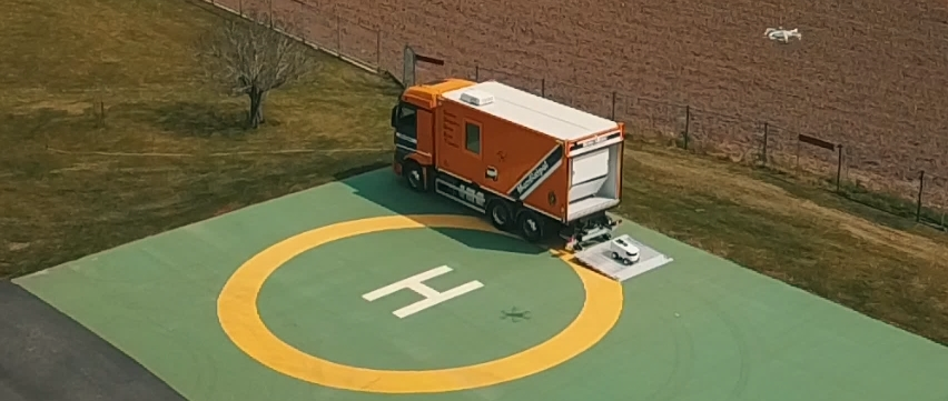
ROVER: Unmanned Ground Vehicle (ground robot) “CMC-Brave” by RPS AEROSPACE
JP-Point: Base for UAVs and Rovers
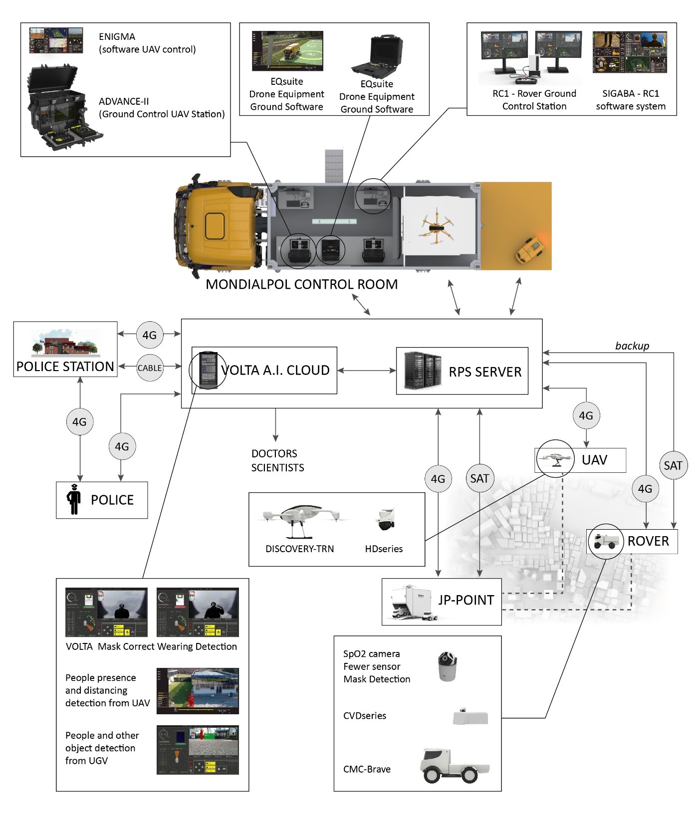
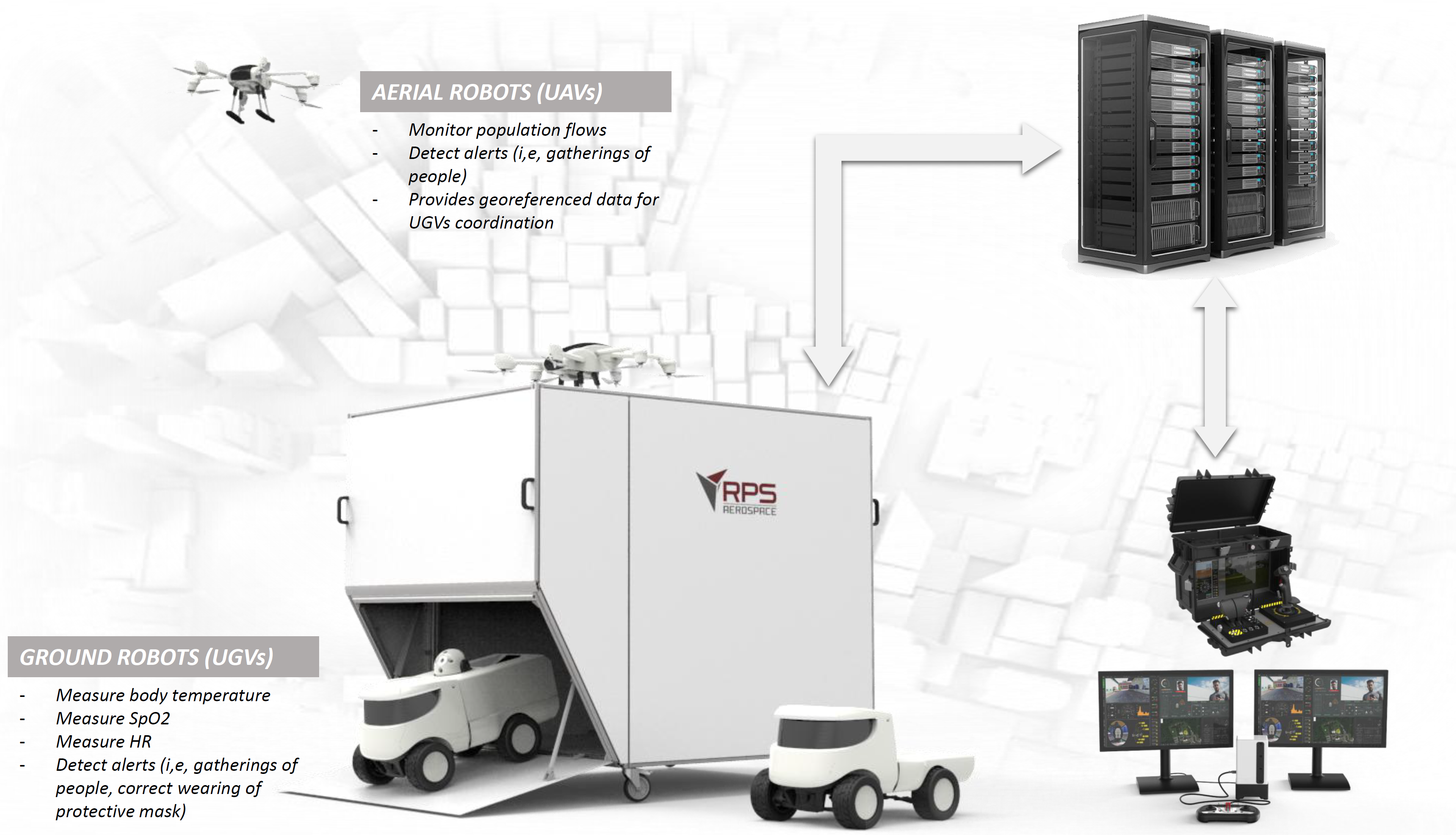
The core of the BePI assets are represented by the robots (UAVs and UGVs) which are able to patrol the areas of interest, collect data and send them in real time to the Control Room and RPS Server via mobile communication and with satellite backup communication systems.
The robots are able to collect up to 10 images per minute of people’s flows, checking the presence of gatherings or of individual subjects and for target subjects it is possible to take measurements of body temperature, blood oxygen saturation level and heart rate. For target, individual subjects it is also possible to check the correct wearing of protective mask and the compliance with the social distancing rules enacted for the containment of the COVID-19 pandemic.
All data are processed and stored on a proprietary and dedicated server, where Volta artificial intelligence algorithms process the images anonymously to detect the desired alerts (e.g. masks, distancing, and fever).
BePI user (e.g. Police bodies) can access raw data in case of critical situations (e.g. risk of spreading of COVID-19 infections), using, if necessary, 4G communication with robots to handover on a pre-planned mission and focus the attention on a specific area or subjects.
Space Added Value
The entire BePI infrastructure relies on satellite communication and satellite navigation:
Satellite communications are achieved thanks to a dedicated module that uses the IRIDIUM satellites system for telecommunications. This allows a cheap and robust remote control and data reception towards the robots when the terrestrial mobile connection gets lost.
The images below show the SIGABATM Ground Control Rover software interface during a temporary unavailability of LTE mobile connection. By simple and reliable communication interface, the remote pilot can send basic but effective commands to the UGV.
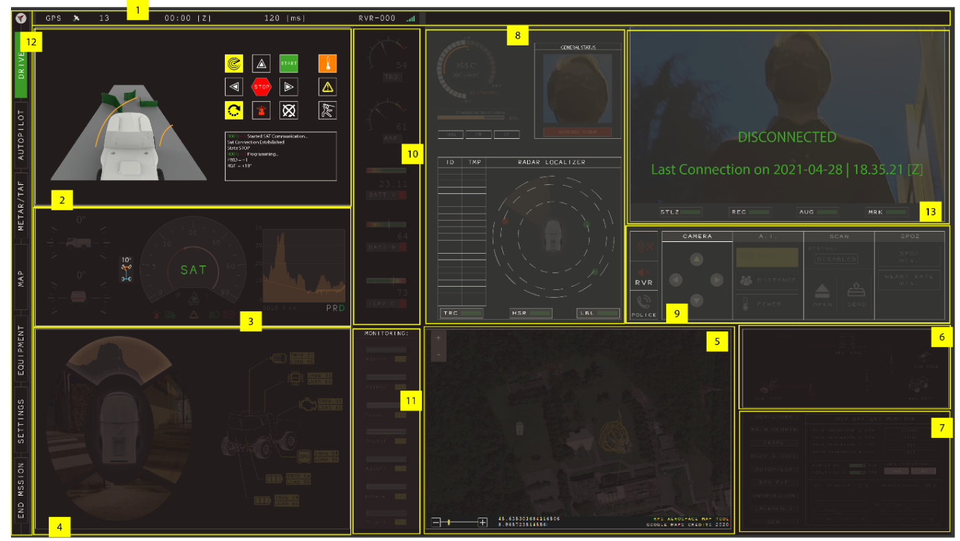
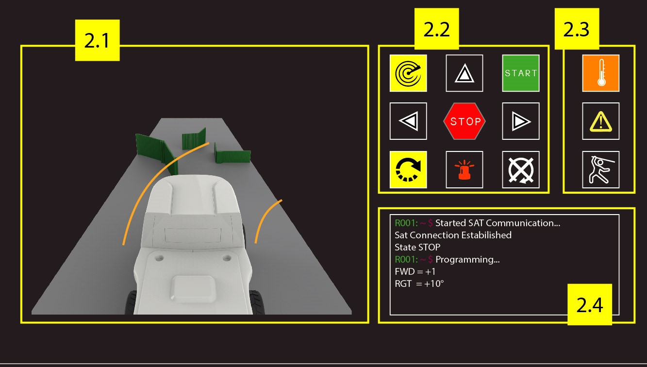
The implementation of backup satellite communication improves the vehicle’s reliability, ensuring the recovery of the rover also if primary communication is lost. The safety towards people around the vehicle is enhanced by the possibility to terminate any vehicle manoeuvre also by using satellite communication.
Satellite navigation, in particular Galileo, is used to provide high precision positioning capability for the robots (UAVs and UGVs). Even in case of connection loss (momentarily or prolonged even for minutes), thanks to the satellite navigation system, the autonomous navigation capabilities of aircraft and rover enable a safe autonomous engagement of emergency procedures (e.g. pre-planned recovery paths).
Current Status
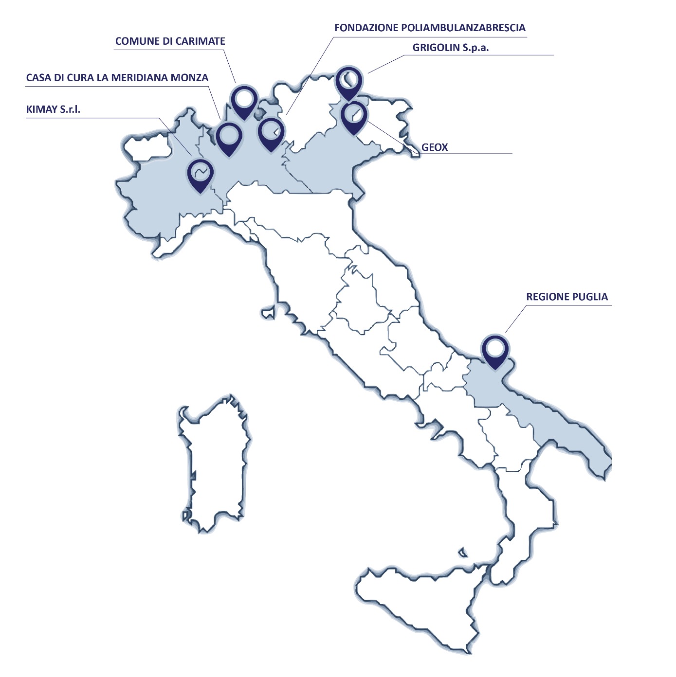
The technology has been deployed and tested, during the pilot project stage, on a subset of users including Italian municipalities/cities, private companies and a private nursing home.
The promoters and official BePI end-users during the pilot project stage are:
-
Bari City
-
Carimate Municipality
-
La Meridiana Due (nursing home)
-
GEOX S.p.a.
-
Grigolin S.p.a.
-
KIMAY S.r.l.

During pilot projects, the BePI consortium has provided services to the end-users asking for a combined service with aerial and ground robot for COVID-19 related services (daily) and security services (night).
During the pilot projects, the technology developed within the BePI project is concretely brought to the end user. This has accelerated the process of building trust in the future, in technology and in the use of collaborative robots.
Thanks to BePI pilot project results the original roll-out plan and related commercial strategy is empowered with the results obtained “on field”.
Specific programs are in place to introduce the technology offered by BePI infrastructure to new customers, where they can test, during an initial phase, the technology coupled with traditional services of security offered by Mondialpol.