Objectives of the service
The BLUE DISCOVERY System is an innovative and powerful technology platform that allows for the deployment of an efficient and low-cost Access Control and Visitor Information System to Marine Protected Areas (MPAs). The same concepts and main functions apply also to Tourist Ports.
Restrictions internal to Marine Protected Areas are often quite complex and not easy to interpret by the visitor. MPAs are divided in Zones with different access rules and allowing for specific activities only (either free of charge or on payment). Surveillance tasks are in general difficult to exercise and, above all, expensive, mainly because MPAs are often very wide and remote and surveillance resources (personnel, dedicated boats and equipment) are limited. Most importantly, efforts and resources required for surveillance are almost always subtracted to the capability of the Park to improve services to the visitors and to the environment itself. A critical aspect for marine Parks is the capability to manage efficiently and effectively all the required information to tourists and visitors.
BLUE DISCOVERY introduces a new and more efficient control model, by means of a real-time management and automatic support to all visitors during their visit, guiding them to ‘discover’ the hidden jewels of the marine area in an easy and immediate way and allowing for an overall optimization of the MPA resources. The system aims to promote environmental conservation through a cooperative and conscious use of the Nature Reserve by the visitor. Moreover BLUE DISCOVERYprovides to the MPAs the capability to efficiently offer a comprehensive set of added value services to tourists, visitors and to the local community.
Users and their needs
Marine Protected Areas and Tourist Ports of the Mediterranean Sea are the main customers and users of the system, but the true end-user is the visitor, who shall be best supported during her/his entire visit.
BLUE DISCOVERY considers the following target areas:
- Management of Marine Protected Areas
- Access Control & Monitoring of visitors, to reduce costs for surveillance and optimize MPA’s resources
- Tourist support & services provision, resulting in added revenues
- Crowdsourcing capability, to increase environmental awareness on visitors
- Management of Tourist Ports
- Management of customers and boats
- Support to mooring, beaching and launching
- Maintenance operations support
- Commercial support (link to administration tools)
- Support to coastal tourism (extension of MPAs and Ports)
- Tourist support & services provision
- Commercial services (local promotion & service offering)
- Support to leisure navigation
- Support to coastal navigation (by means of Augmented Reality contents)
- Fleet Management & Telemetry
- Electronic Pilot Book (Portolano).
Some system functions are also of interest to other stakeholders, such as Environmental Organizations, to which the Marine Areas can easily provide crowd-sourced data related to the environment and fauna reports, and National and International Organizations responsible for Safety (at sea and on land) interested in reports related to potential dangers to navigation and to the emergency call functionality.
Service/ system concept
The BLUE DISCOVERY system is a Client-Server & DB-based architecture, consisting of a client mobile App free downloadable on any mobile device (smartphones and tablets), a web-GIS and an Operation & Maintenance Portal managed by the MPA/Port Operators to control accesses to the protected areas and to manage and configure the overall system and its services. A specific mobile management App is also available to be used directly on the territory by the MPA Operators to check for authorizations and to communicate with visitors (Park Operator Terminal).
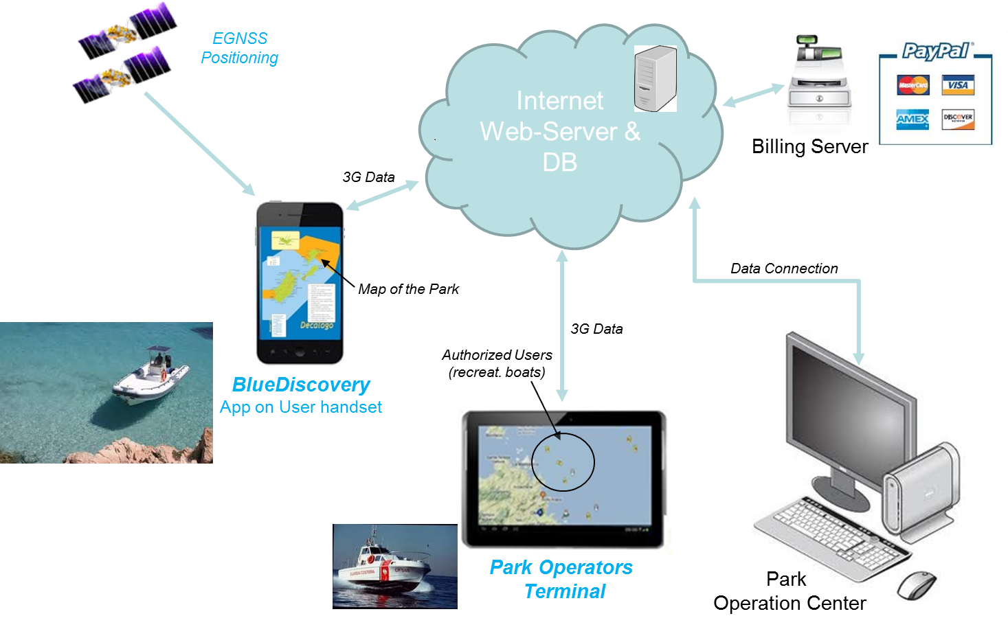
Figure 1 – BLUE DISCOVERY System Architecture
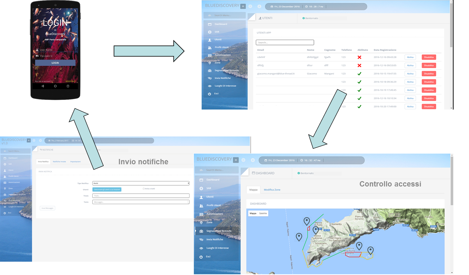
Figure 2 – BLUE DISCOVERY web Portal
The BLUE DISCOVERY system functions can be easily adapted to the different applications and to the specific MPA’s needs and include:
- Easy monitoring of the marine area
- Efficient monitoring and management of visitors
- Management of services (accesses, authorizations, moorings, guided tours,..)Notices/Warnings to visitors/mariners
- Promotion of local events to visitors
- Statistical analysis of tourists flows and MPA resources usage (to improve planning and services to users and to be able to develop real environmental protection strategies)
- Real-time bidirectional communication capability (visitor/MPA)
- Crowdsourcing function: possibility for the visitor to send to the MPA short reports accompanied by geo-referenced photos related to pre-configured categories (Environment/Safety)
The system provides the following services to the visitor:
- Tourist Information and automatic guides to profiled itineraries
- Light procedures in obtaining permits and authorizations
- Location Based Services (free or with payment: guides, local events, environment/safety related info, areas allowed for diving/fishing/anchoring, booking/payment of moorings and dockings, garbage collection and water/fuel provision at sea for leisure boats and many more)
- Augmented Reality contents & Virtual guides
- find-your-mates service, to easily locate and communicate with friends and relatives during outdoor activities (Social community)
- Commercial Services (advertising and promotion of local products and activities).
- Emergency Call (eCall), to provide to the outdoor tourist an important and easy-to-use Safe of Life tool during her/his visit.
Space Added Value
BLUE DISCOVERYmakes use of the latest European Satellite Navigation features (EGNSS). In particolar it uses the Galileo system for improved navigation service performance, increased position accuracy and authentication.
Thanks to the use of Galileo, the system generates precise and reliable GEO-referenced augmented reality contents, which will guide the tourist along her/his route in a simple and, above all, safe way. The distinctive features of Galileo (accuracy, high service availability and continuity and its future services, position authentication and certification) are crucial to the delivery of innovative location-based pay-per-use services and for the support of regulated services. For pay-per-use services (such as automatic tolling to the MPA or to mooring docks to Ports, or the booking & payment of services from remote) the Galileo Commercial Authentication Service (CAS) will provide authenticated, anti-spoofed certified positioning, thus to avoid possible legal disputes between the user and the MPA/Port. The Galileo Commercial Authentication service is in fact based on additional navigation signal in a different frequency band with respect to the Galileo Open Service (OS) and on signal code encryption, allowing for increased robustness for professional applications. While Galileo CAS is not available, the Galileo OS-NMA feature can be used to validate the user positioning. For regulatory services, to warn users on not permitted behaviours, such as GEO fences and speed limits, the Galileo OS provides a more robust and reliable positioning than GPS.
Current Status
The Demonstration Project was successfully concluded in April 2020.
Most of the Italian MPAs have been involved to assess their interest and willing to collaborate to the system definition and experimentation. Also, feedbacks from some tourist ports, foreign MPAs and from other Italian Orgs responsible for Environment and Navigation Safety have been collected and considered during the project.
Three main Italian Marine Protected Areas (Punta Campanella MPA, Porto Cesareo MPA and Egadi Islands MPA) and La Maddalena Archipelago National Park were Partners of the project and hosted the pilot demonstration at sea during the summer 2019 (five months pilot).
The operational service is expected to be available first in these marine areas and soon in all other Italian MPAs.