Objectives of the service
The aim of Cert-EO („Certified with Earth Observation”) is to apply Earth Observation solutions to support certification procedures of organic farming. The feasibility study project focuses on a service that can complement the personal on-the-spot checks with serving gap-filling data about a selected area, parcel or crop by automated analysis and evaluation of remote sensing (satellite) images. In this way, verified and applicable Earth Observation capabilities result an efficient tool for identifying and avoiding both incidental discrepancies and fraudulent actions.
1. Identification
The analysable land(s) has to be actualized and identified in a way that its geometry includes every change that occurred around the plot(s).
2. Crop type
Utilization of the area: detecting land use (agricultural or other) and identifying the crop (type) cultivated there.
3. Proving organic farming
Differentiating organic and conventional farming by the analysis of the life-cycle of the cultivated crop(s).
4. Field control
With development of a respective mobile app, farmers could be involved in the field visit process by making them possible to take verified photographs of their lands.
5. Verification/Certification
The lands could be verified by field visits by the service provider as well, complementing the certifiers’ work.
Users and their needs
Priority customers are organisations and companies performing certification processes in organic farming sector.
To explore user needs, altogether 12 certification bodies from 8 countries have been contacted through surveying and online discussions up till now. Their answers clearly show that GIS and EO-based technologies are rarely used during certification processes. Usage is bordered to controlling location and field size, although yield estimation possibilities are also known. The interviewed control bodies would be interested in using EO data for checking in case of suspicion of irregularities, as well as for data collection/verification and remote auditing. Willingness to pay would be high in case of crop check, plot/field check in case of suspicion of application of unallowed substances. As one of the interview answers says: “Satellite data may be supportive in terms of delivering information on irregularities. This would help control bodies to know where investigation is necessary.”
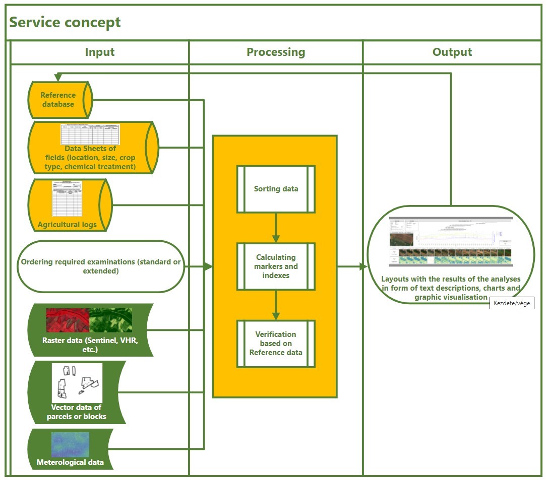
Service/ system concept
One of the novelties of Cert-EO is that a fully implemented future service will synthetize several, separately existing models and calculation methods in order to serve complex scene of the investigated organic fields, disclosing deviances of different origins in one process.
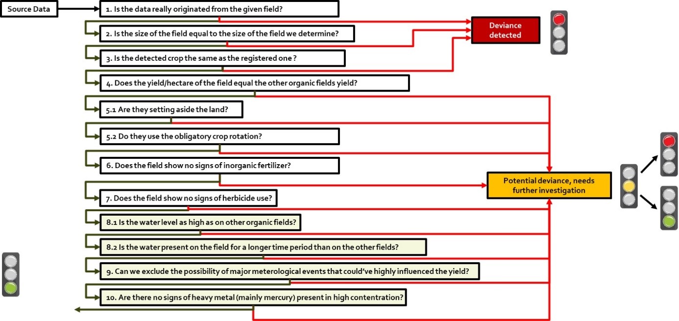
Targeted user needs – available examinations of the fully implemented future service:
Standard examination:
1. Location verification
2. Field area measurements
3. Crop identification
Extended examination:
4. Yield estimation
Examination of organic farming requirements:
5. Examination of fulfilling land use criteria (if acceptable), e.g. crop rotation, compulsory set-aside, vegetation between rows
6. Examination of growth (e.g. nitrogen uptake) based on spectral indices, compared to other organic fields
7. Detecting indications of herbicide or pesticide usage
Examination of water coverage:
8. Timespan of water coverage; water level
Examination of damages
9. Detecting harmful meteorological events
10. Detecting heavy metal content
Additional tool: mobile application for voluntary, verified data reporting by farmers.
The above-mentioned grouped examinations represent the price of the product, the standard examination is our base product and all other examinations can be ordered as an extra feature depending on the needs of the user.
A mobile application should help the farmers to voluntarily report data of their parcels by making verified photos that are applicable for visual identification of crops or events/phenomena. Verified data reporting of farmers could complement on-the-spot checks in a low-cost way.
Space Added Value
Cert-EO would be based on the exploitation of ESA’s Sentinel-1 and -Sentinel 2 satellite images, which are a significant part of the Copernicus Programme.
Processing workflows are based on GeoData’s existing and continuously developed monitoring technology, which gives the core of the analyses required in this project. In frames of Cert-EO project, the general monitoring technology is being specialized for organic farming requirements, mainly by building specialized markers that can demonstrate or prove the organic characteristics. Markers are calculated from Sentinel images through several processes and then modified according to meteorological circumstances. Since most of the examinations can be interpreted through time series data, marker sequences are generated from the time series of usable Sentinel image of a parcel/area.
Development processes would be supported by verification based on very high resolution (VHR) imagery. 150 sqkm Pleiades or other equivalent VHR is planned to be used. Apart from EO imagery, Global Navigation Satellite System (GNSS) satellites would be used for navigation during field visits and geotagging the photos of the mobile application. In frames of Cert-EO project, the general monitoring technology is being specialized for organic farming requirements, mainly by building specialized markers that can demonstrate or prove the organic characteristics. Markers are calculated from Sentinel images through several processes and modified according to meteorological circumstances. Since most of the examinations can be interpreted through time series data, marker sequences are generated from the time series of usable Sentinel image of a parcel/area
Current Status
Cert-EO feasibility study project successfully reached MS1 in December 2021, after 3 months of the one-year timespan. The Project has reached MS2 in May 2022 and it was finished in September 2022.
Besides reviewing existing technologies and methods for implementation, selecting the examinable crops and gathering sample data for the first steps of technology development, the service concept has been set up for further assessment. The list of examinable crops has been finalized. (Rice, grape, corn, sunflower, paprika, winter wheat, rape) The main focus is on corn. Testing it from all aspects is in progress.
As part of the identification of end-user needs and requirements, altogether 12 certification bodies from 8 countries have been contacted through surveying and online discussions up till now, in order to clarify user needs and get the service concept justified.
We are in contact with Hungarian and German certification bodies, because the main focus is on developing a service most suitable for the end users.
The system architecture is ready. The technology is highly dependent on the services of ESA so for that reason the key service we need is downloading satellite imagery for processing. In the current state of the technology we download Sentinel-1 and Sentinel-2 imagery from multiple sources (Creodias, Sobloo). The process is fully automated and uses Unix shell scripts and Python codes. The process now needs a linux based server. The downloaded data is the stored on a file server.
What makes these technologies stand out compared to the other ones is that it has a potential use case monitoring mandatory crop rotations in countries where that is regulated by the law.
The planned system highly depends on the needs of the user and the scale of the order, most processes should be automated. The exact specifications are based on Geodata’s existing and continuously developed monitorsing technology, which gives the core of the analyses required in this project.
See the proposed flowchart below:
The Cert-EO project have gone through the Final Review successfully. The feasibility study is finalized.
The team is currently planning to step into the next phase: demonstration project.