Objectives of the service
Climate change impacts coastal areas through the rise of sea level amplifying the impact of extreme natural events such as hurricanes and coastal storms. Sea level rise induces shoreline erosion, coastal flooding, water salinization and more, threatening the livelihoods, population growth, urbanization, and natural ecosystems. It drives thus significant economic losses and affects the built-up areas behind the coastline.
Thanks to the latest advanced research and satellite observations, CORISCLIM tool reports on future climate-related coastal risks wherever, until 2100, along several scenarios to make decision ahead of time (e.g. to mitigate impacts, to update plans, to launch additional in-depth studies, to strengthen local capacities and build coastal resilience, and more).
Users and their needs
CORISCLIM tool is fitted to the use of:
-
Coastal authorities protecting the coastal communities, lives and property.
-
Coastal engineering firms & consultancies and companies providing solution to manage coastal zones and their risks.
-
Development banks or private investors funding climate resilience actions.
-
Climate Insurance firms evaluating future impacts on their clients’ assets.
-
Environmental associations and organizations (NGOs) supporting climate change awareness and actions in favour of climate change.
With CORISCLIM, users can:
-
Identify the most probable impacted areas (populated areas, natural areas, ….), due to future coastal flood hazards driven by the mean sea level rise and extreme events,
-- to prioritise places and plan actions for raising funds, for launching more precise analyses which requires more time and resources; -
Carry out preliminary studies at local scale
-- to ensure a homogeneous assessment for low lying coastal zones, applying different settings along specificities of territories -
Communicate results in a simple way
-- to convince an audience or to communicate / promote their activities thanks to high quality data and proven user experience
Service/ system concept
CORISCLIM solution replies to the shared and consolidated interest of our user community:
-
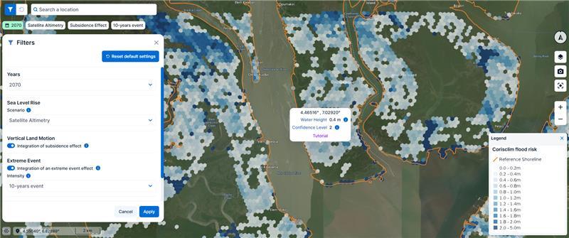
To have a homogeneous assessment at the world level for a first screening of flood hazard level at 300m resolution;
-
To simply visualise the near-future flood hazard for all the coastal zones below 10m elevation, and its projection until 2100 along different settings (considering or not the impacts of extreme sea level and/or the effects of land subsidence);
-
To propose credible and reliable mapping of impacted area and flood height with a confidence index (an EO-based approach with strong expertise);
-
To propose an experimental product projecting the position of the future coastline from the past observation of its displacements;
-
To have the solution available with informative content and tutorials, as well as a one-to-one training event, a differentiating factor from open-source solution and learn it yourself;
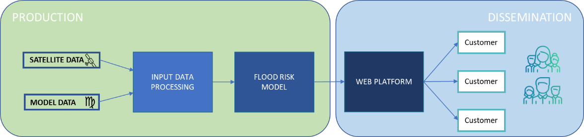
The system and service architecture is schematised below:
Space Added Value
Four satellite systems provide this unique opportunity to survey worldwide coasts and oceans:
-
Radar altimetry: for the dynamics of the oceans (change in sea level, waves, storm surges, tides)
-
Optical imagery: for the coastal shoreline & erosion
-
Radar imagery: for the terrestrial digital elevation model
-
Telemetry & GNSS: for vertical land motion
Current Status
The project has been conducted from February 2023 till November 2024. The project reached its two main objectives:
-
To implement a solution (successful integration of new components based on satellite data, operational tool with reproducible coastal flood estimation art worldwide scale, online re-designed web interface to disseminate the products)
-
To get all categories of users tried the solution, plus an in-depth analysis by AXA Climate.
The service has been validated. It is now operational. If you are interested by the solution, please contact us for a demonstration.
Prime Contractor(s)
Subcontractor(s)