
Objectives of the service
The service objective is to develop a solution for scalable, crowd-sourced seafloor mapping aimed at supporting the maritime industry with better sea maps. The solution exploits that most fishing vessels are equipped with an accurate echo sounder which can produce valuable samples of the water depth where vessels are sailing. It also exploits the new AIS 2.0 (VDES) data transport option available over both satellite and coastal VHF radio, as well as other connectivity options, such as mobile networks in near-shore regions. By implementing a solution that can be installed on many fishing vessels at low cost, the responsible maps authority can get access to large volumes of data for sea map production.
Users and their needs
The service is targeted at Map Authorities, in particular The Danish Geodata Agency, which is an already signed customer.
End-user segment and their needs:
-
Cruise fleet – the need for maps covering remote areas
-
Merchant fleet – delivering food supply to remote arctic communities with the need for safety on the sailed routes, especially near ports and in fairways
-
Navy – the need for safety and strategic planning
Market demand and customer/user needs:
Fishing vessels do not follow the common sailing routes; therefore, the generated data is going to be more valuable for bathymetric purposes. Scale is important for crowd-sourced bathymetry (CSB), and the amount of active fishing vessels is big. Fishing vessels would accept to install bathymetry data harvesting equipment on the ship to help map authorities in exchange of upgrading ship AIS equipment.
Service/ system concept
Crowd-sourced bathymetry solution is developed for the maritime industry application. The aim of the service is to get access to echo sounder data onboard ships and transfer the data for post-processing by the map authority. The service makes use of Sternula’s AIS 2.0 connectivity, which can be combined with e.g., cellular mobile connectivity when in near-shore waters. The final output of the service is new, accurate sea maps.
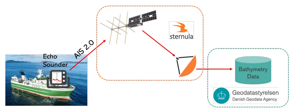
In the solution proposed, periodic reports of data are continuously transmitted via AIS 2.0, especially, when the data is considered as “urgent” or “sensitive”. In the future, when the high-data rate connectivity is available, larger volumes of data can be retrieved.
The key commercial activity is the thorough analysis of the value chain.
The key R&D activity is development of certain elements of the data collection unit to be deployed in fishing vessels:
-
Software that enables remote fleet management of the deployed equipment, e.g. to push “software updates” over the air onto units that have been installed on ships earlier, or to change configuration of the deployed units.
Space Added Value
The offered value proposition is a scalable data collection platform for ships, including the global data connection through Sternula’s satellites.
The use of satellite connection is important for the cases where measured data is citicial for navigational safety. As focus of the solution is on remote waters, where connectivity is often a problem, only satellite communication can deliver a robust and reliable way to transport urgent data.
By the use of the open standardized VDE satellite technology, in the future it is likely that the cost of implementation would be lower because part of the equipment can be expected to be on board already.
Current Status
Final Review passed in July 2023.
Prime Contractor(s)