Objectives of the service
The current pace of community resilience to climate change and adaptation to new climate conditions is insufficient. Climate change is progressing in line with the formerly pessimistic scenarios. Most cities and regions, which are crucial for development and investments in the managed area, are not prepared for such rapid progression.
The CTAPP will be tailored to urban environments, addressing unique climate change challenges. Using the CICs (Climate Impact Chains) methodology, it will analyze and model the cascading effects of climate events in cities, enhancing understanding of impacts on infrastructure, populations, and economies.
By utilizing EO (Earth Observatory) data, augmented with ground-based sensors and local meteorological information, the service will provide insights into urban vulnerability to climate disasters. This data will help cities anticipate, plan for, and mitigate extreme weather and climate-induced challenges.
The service will aid urban planning and development, enabling informed decisions on infrastructure, land use, and resource management to build resilience. Engaging local governments, urban planners, and community leaders will ensure the service meets urban needs and addresses unique challenges.
Users and their needs
The CTAPP project primarily targets municipalities, environmental advisors, and investment project supply chain teams across Europe. These users depend on advanced tools and data to enhance urban climate resilience and make informed decisions regarding climate adaptation and mitigation.
User Needs:
Overview of Possible Climate Impact Chains (CICs): Comprehensive understanding of potential climate impact scenarios for effective planning.
Data Management: Ability to save and display historical graphs, data, and outputs for trend analysis and decision-making.
Climate Risk Vulnerability Calculation: Tools to assess and visualize the vulnerability of different areas to climate risks.
Data Transparency: Display of both EO and non-EO data descriptions used in calculations and risk assessments.
Data Updates: Regular updates of specific data sets to maintain accuracy and relevance.
Climatic Event Prediction: Predictive tools for climatic events and associated risks.
Demonstration Use Cases: Examples and references to illustrate the solution’s effectiveness.
Technical Support: Continuous updates and robust technical support to ensure system functionality.
These needs address the core challenges faced by users in integrating diverse data sources, conducting detailed climate risk analyses, and utilizing predictive models for climate events. The targeted countries include Germany, the Czech Republic, and Finland, among others in Europe.
Service/ system concept
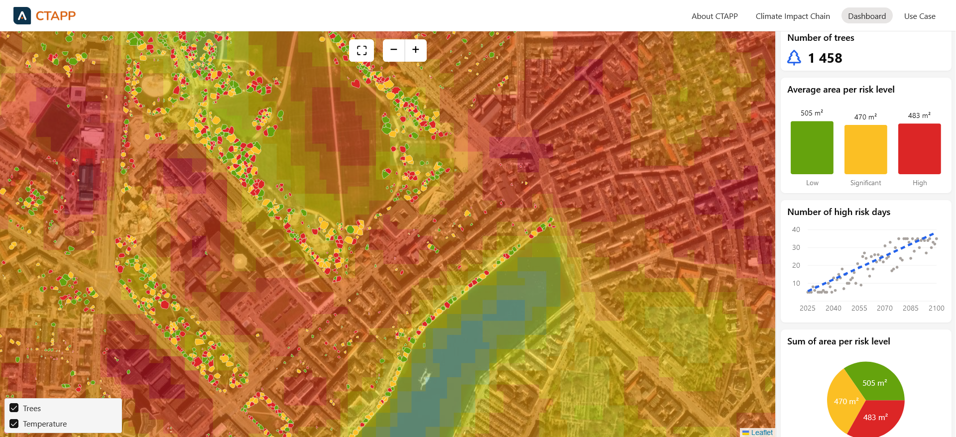
The CTAPP system is designed to provide users with outputs that are specifically tailored to their inputs and requirements, ensuring that each output is personalized. The primary output is presented as causal diagrams, known as Climate Impact Chains (CIC), which are custom-created and delivered through an interactive application. The nature of additional outputs varies depending on the type of CIC and the data supplied. For instance, if a user constructs a CIC focused on the health of individual trees, the output will include a map displaying the trees and their relative vulnerability. Users can also aggregate data for their chosen spatial units and receive maps representing those units.
Moreover, outputs are produced in the form of graphs, particularly for temporal data, and as numerical values, provided that all necessary variables are available (e.g., the number of people affected by negative impacts).
Users have the capability to construct custom CICs using the CTAPP interface. The application offers a list of climate hazards, and users can select the causal effects that are relevant to their specific scenario. Additionally, users can identify exposure agents and assess their adaptive capacity. Following these selections, users can develop a CIC that generates outputs in a format that best aligns with the requirements of their CIC.
Space Added Value
The CTAPP utilizes available remote sensing data primarily sourced from Earth observation missions conducted by the European Space Agency. These data sets are accessible and feature high temporal and relatively high spatial resolutions. The analysis of remote sensing data yields information on the effects of climate change on urban ecosystems. For example, it enables the monitoring and assessment of vegetation health and the impact of extreme weather events. Remote sensing data can be integrated with other databases, such as municipal data repositories or open databases, via Geographic Information Systems, thereby improving the scope of predictive and exploratory analysis. Furthermore, the availability of remote sensing data across the entire continent allows for consistent and comparative analysis across different case studies.
Current Status
We created a mock-up and presented it to several cities representatives. We received valuable feedback and incorporated it into the development plan. We have created and validated 3 climate impact chains and have another 10 chains in progress. We want to cover more climate drivers and impact areas to increase interest and broaden the potential client portfolio, as different regions face different climate challenges.
Prime Contractor(s)