Objectives of the service
Like other developing to middle-income countries, in Bangladesh there is a lack of appropriate agricultural data regarding crop acreage, input usages, crop growth or yield data etc. Remote sensing based agricultural data generation using satellite data, presents the most economic and efficient way out.
Field boundaries in combination with weekly satellite imagery can automate field-scale crop health monitoring as well as provide valuable insights and actionable information, which can be used by policy makers to derive effective policies for countrywide sustainable agricultural development. On the other hand, farmers’ profitability heavily depends on input costs like fertilizer, however farmers have limited or no access to actionable information services like fertilization recommendation. The PND service, in combination with weekly satellite imagery can provide dependable agronomic recommendations based on plants’ need to improve yield as well as reduce environmental pollutions.
During this feasibility study, we want to verify the technical feasibility and check commercial viability and develop a business case for a demonstration project.
Users and their needs
DASF identifies the end user as farmers with their specific needs. At present in the Asia-Pacific region there are ample need of tools and techniques to manage agriculture input and optimize output. For an instance, in the case of Bangladesh the prime customers are agribusiness companies, microfinance & insurance companies, government agencies as well as end user farmers who are lacking a digital decision support system. In Bangladesh the main crop rice price hit 3-year low. Although, the production is much higher farmers are not getting demanding price, whereas, they have a high production cost. The production cost is higher as they literally do not have any fertilization recommendation tools and they cannot optimize the production cost. On the other hand, Bangladesh government and all other private organizations are lacking exact statistics of agricultural field area wise production. At present there are no mechanism to estimate cropped area and thereby to estimate the amount of production. The microfinance and insurance companies are also not able to calculate the exact need of loan and the ability of repay by the farmers. The agrobusiness companies cannot increase their sell as they are not able to quantify the input needs. This is because all the customers have no updated field boundary. At present all the field boundaries are measured in a very old and traditional way and the database is also very old. Thereby, to digitize the agriculture of Bangladesh all the stakeholder need updated and digitized field boundary.
API services:
- Field boundary detection API (e.g., the field area is 0.75 hectare)
- Field productivity calculation API (e.g., field productivity potential is 88%)
- Fertilization prescription API (e.g., the plants need 20 kg/ha Urea for optimal growth)
- Regional crop classification statistics API (e.g., in Dinajpur District, 227,440 hectares of land are cultivated with rice crop)
Service/ system concept
In our existing and proposed service architecture, we showed three core technologies i.e. Satellite remote sensing, Mobile phone photos and the AI algorithm running in the cloud service. The core technologies always remain the same but there might be change in some input data sources. For an instance, maybe we have to adapt the local positioning system, we might have to use Landsat data rather than Sentinels in some seasons based on the image availability, also, it might be a case that the Android systems are more useful than IOS etc. The cloud system remains the same as it is accessible from the remote. The overall process is that, when a user uses the proposed service by an app then they trigger the application running in the cloud (i.e. satellite imagery processing algorithm and AI model-based prediction algorithm). In a fraction of minute, they get the service as a result in their mobile or in an email account. The system requirement and service architecture therefore can be the same with no major changes for any replication or scaling it up globally. Although, not every farmer has the smart phone or internet connection in their mobile and thus we studied and found in the feasibility study a rational solution. Maybe the corporate, government and their consultants have smart phones and every field level government worker also have smart phones with internet connections in their mobile and they will support those remote farmers. Moreover, In the targeted study region we have 3G connection from mobile phone providers.
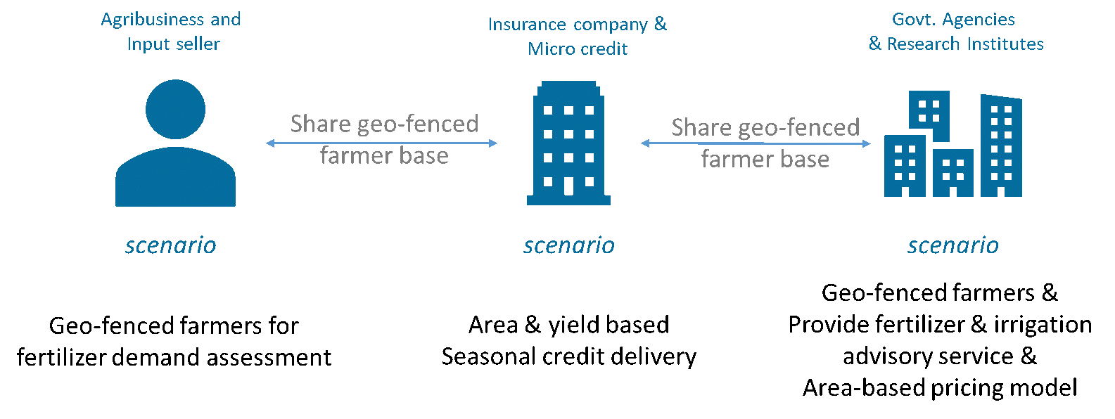
Figure 1: Service/System Concept
Space Added Value
Spacenus makes use of EO data of Sentinel-2 images, additionally GNSS information for computational applications. Based on Sentinel-2 images, our system enables the generation of Field Boundaries, relative nutrient deficiency maps and field productivities. Combined, the above-mentioned components provide field zone management recommendations for farmers.
Because satellite images only deliver relative values, Spacenus counteracts this with our AI driven PND system. DASF calibrates satellite images for each field with in-situ sample pictures of crop canopies with the assistance of the LCC. When taking a photo with our tool, the phone also connects with the GNSS to provide the geolocation of the picture within the field. GNSS is also used to generate the variable fertilization map.
Working with satellite imagery enables DASF to cover entire fields at once and the five essential nutrients for growth of a plant, which are important factors in terms of time- and cost-efficiency, and thus in scalability. The small field size is the critical challenge for providing satellite-based services to the smallholder farmers in Bangladesh. According to our study there are about 8 fields per hectare. To provide service to smallholder farmers we have to find an efficient way to make use of 10-meters resolution satellite imagery for smaller agricultural fields. This can be addressed by Automatic field boundary detection and usage for clean satellite image pixel selection to extract crop-specific reliable spectral signature based quantitative information for precision agronomic decision making.
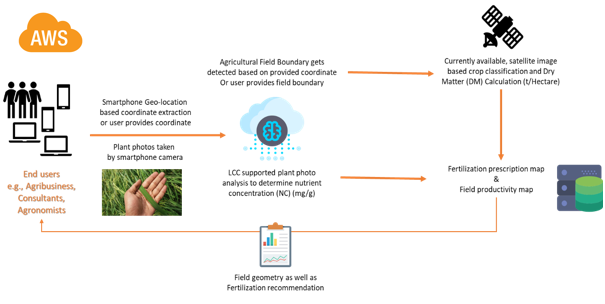
Figure 2: The process flow for nutrient detection, field productivity map and fertilization application map preparation
Current Status
DASF project officially kicked off on 22 July 2019. After the project started, we have met framers and agricultural consultants to understand the current situation and demand in the ecosystem of digital/precision farming products in Bangladesh. At present we have managed to contact and agreed to collaborate with 2 Agricultural service providers, 3 Universities, 2 Government Agencies, 2 Agricultural corporates, 2 Microcredit institutes, 1 Insurance company, 2 NGOs and 2 INGOs.
Spacenus has successfully completed the mid-term review of DASF on 5 December 2019 via teleconference with ESA. The final review will be held on 5 February 2020. The results of the Kick-Start feasibility study will lead to the start of the implementation phase. By the 1st quart of the 2020 we want to finalize our customers and partners commitment agreements and by the 3rd quarter of 2020 we are expecting to start working on the Demonstration Phase.
Prime Contractor(s)