
Objectives of the service

The following objectives are covered in this project: the feasibility of creating a service that enables users to:
- Minimize risks by providing accurate information relating to hazards such as weather conditions, maritime traffic and environmental pollution
- Increase the efficiency of operations by providing up to date knowledge of the field and reducing down-time due to weather and resource misallocation
- Reduce costs by providing improved scenario planning in advance of decommissioning, as well as minimising/optimising vessel usage resulting in a reduction in fuel usage and therefore reduced Green House Gas (GHG) emissions.
- Through extensive engagement with potential customers BMT and 4EI developed a proposal to explore ways of improving existing processes around Environmental Impact Assessments (EIA) both before and after decommissioning.
Users and their needs
The main users of the service would be the operating companies who are organising the decommissioning of assets in addition to the service companies and regulators as it would allow monitoring of in-field conditions, activities and progress.
One of the main cost drivers with decommissioning is risk: the unknown unknowns. The project consortium aimed to address this by providing up to date data to enable timely and ongoing assessment of environmental risks.
The main area of interest for this service has been within the North Sea.
Service/ system concept
The project team developed the idea for a service around the fact that there is a substantial amount of EO data generated every day and that there are specialists in analysing it. The issue is connecting customers to the data. The team sought to democratise space-based EO information and help customers explore the available data and its uses in terms that relate to their challenges and needs. The concept was similar to that used for price comparison websites where consumers run searches and are presented with products and services that meet their needs. The free-to-use service then connects customers to the product and service provider and if a transaction is successful then a royalty fee is paid. Due to the specialist nature of the service the team also believed that a subscription model would be appropriate especially in the early years whilst popularity for the service grew.
Below is the service model showing the key elements of the service:
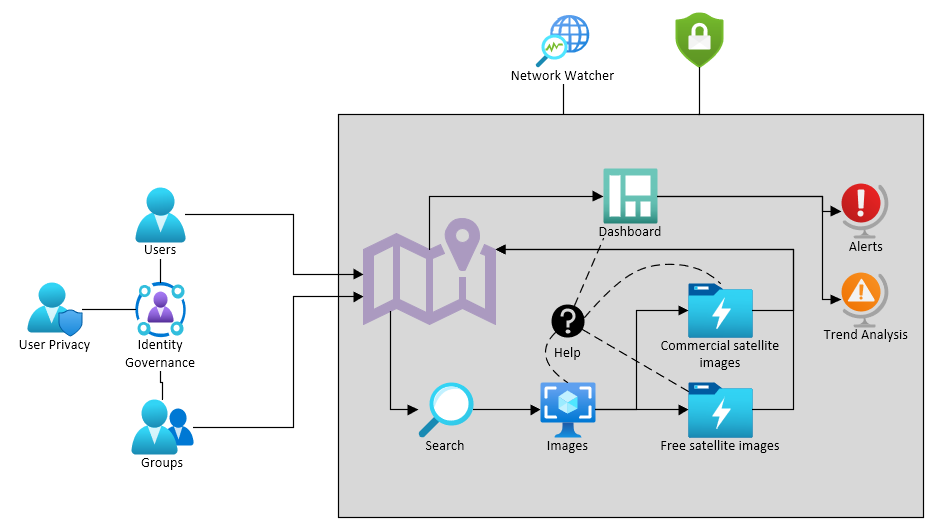
The service will take multiple data feeds, integrate them and make them available to display as a Common Operating Picture (COP) in order to provide a comprehensive understanding of the area of operations. The provision of historic satellite data, recent data sets and future image capabilities will enable users to better understand the movements of assets and the environmental markers.
During the operational phase the application can be used to take live data from various feeds to create the COP and enable better situational awareness to all actors (e.g. other operators, workboats, regulators) operating in the area of interest. The COP will be available to all users with access to a data device with the application loaded and updated via the designated bearer in order to assure and maintain the safety of personnel and equipment as cost effectively as possible.
Post decommissioning activities will continue to present the COP for situational awareness of any environmental threat in order to identify the nature of the threat, inform the appropriate organisation, act on the information and rectify the issue as quickly and as cost effectively as possible.
Space Added Value
Space assets are of great value in terms of scalability, spectral detections and cadence, particularly for large and inaccessible areas. Offshore assets are by their very nature remote so comparable monitoring techniques, such as drone or aircraft, can become extremely expensive and limited by the ability to deploy in all conditions and when needed.
EO data provides the opportunity to monitor areas of interest remotely so that environmental data can be analysed either directly by the user, or by another service to provide baselining of the pre-activity environmental conditions and ongoing environmental monitoring and detection of harmful liquid spills, seepage and greenhouse gases that may be released during the decommissioning phase, accidentally or otherwise.
Current Status
Having established in the Business Plan that the idea, whilst technically feasible is not commercially viable, the team have created a Roadmap of how the idea could be adapted to address this. The project team have looked at the pricing model used, the market the idea is aimed at and conducted a Learning From Experience workshop in order to draw up a series of recommendations for how the project could progress to address the commercial viability. This work will not be continuing to a demonstration phase at this time and the BMT team will look to address the issues identified in the Roadmap outside of this study.