Objectives of the service
The objective of the service is to provide a cost effective high accuracy Snow Water Equivalent product that can be used for short/long term hydropower optimization. Provided weekly, DeFROST transmits the amount of Snow Water Equivalent in a catchment area that will be used to infer the future total water inflow and, therefore, total amount of energy. In this project, Wegaw aimed to demonstrate the viability of the product both from a cost and accuracy perspective for ENEL.
Users and their needs
Currently hydropower companies calculate SWE the following ways:
-
Weather station based meteorological/physical model: Through the tracking of temperature, precipitation and modelling of snowfall and snowmelt.
-
Snow pillow based interpolated model: Snow pillow sensors can calculate SWE through point-based measurements that can be interpolated to create a basin wide SWE product.
-
Field measurements, normally taken 1-2 times per season with poles in key locations of the basin.
-
LiDAR flight measurements by drones, normally covering areas of up to 4km2.
The above listed existing methods of snow measurement do not provide both a cost-effective and high-accuracy solution.
Modelled insights based on weather stations are point-based with the space between the points interpolated, which means these models require a densely packed network of ground sensors covering the dynamic characteristics of each basins to account for spatial variance.
The same logic applies to snow pillows and field measurements, which are often highly expensive due to the staff and hardware requirements and do not present a solution for the constant monitoring needs.
Service/ system concept
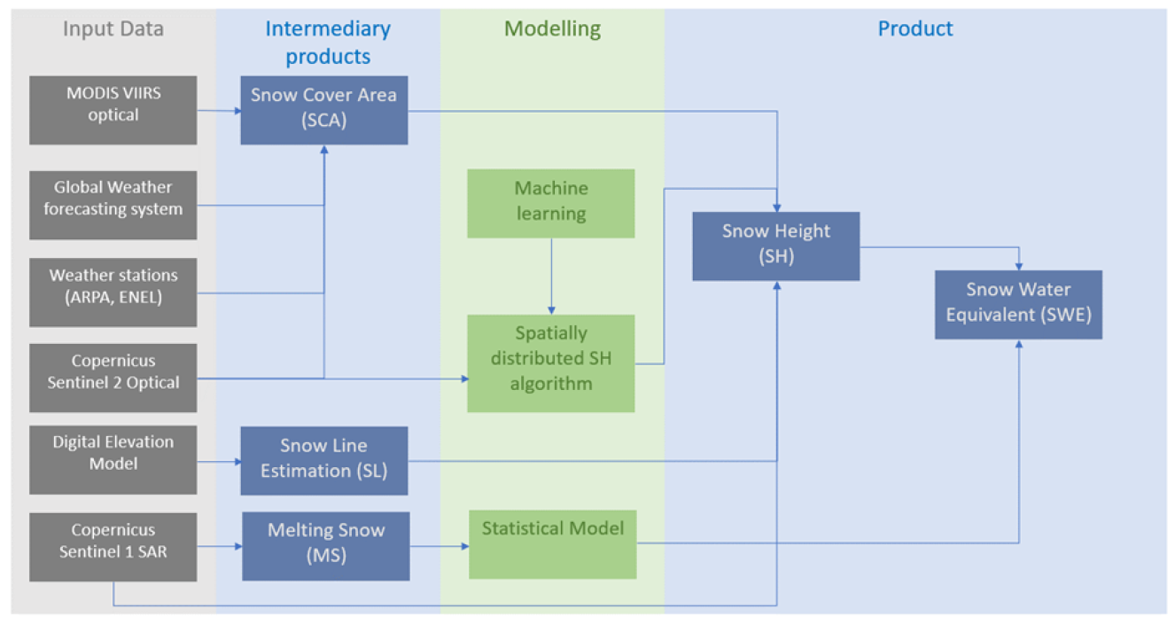
DeFROST is delivering SWE values to be ingested in different energy and water inflow modules. In order to do this, the system needs to be able to produce SWE data live and on demand. The inputs used are the following:
-
Optical satellites (Copernicus Sentinel-2, MODIS and VIIRS) for approximation of the spatial distribution of the snow covered area and snow line and calculation of indices.
-
Sentinel-1 Synthetic aperture radar (SAR) satellites to track changes in snow through time-series change detection.
-
Digital elevation models (DEMs) and airborne LiDAR systems as inputs for snow distribution models.
-
Ancillary data for signal interpretation such as CORINE Land Cover (CLC 2018), Copernicus Pan-European High- Resolution Layer on Tree Cover Density, and Copernicus water body maps.
Based on this raw data, the first intermediary products are build (SCA, SL and MS), that are going to be used to model the Snow Height product first using the spatially distributed SH algorithm, later using the statistical model combined with the MS product, the final SWE product is going to be build.
Space Added Value
DeFROST is based in a combination of the following satellite assets:
Optical satellites: MODIS VIIRS and Sentinel 2
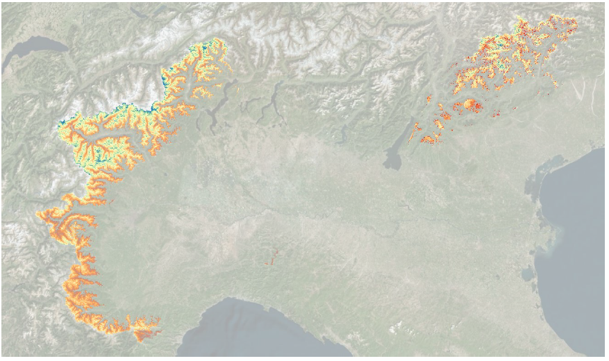
Optical sensors are used to extract the snow cover area and build a snow mask to understand where there is snow or not. This data is used to build the snow line to locate the minimum elevation where snow will occur.
SAR Satellites: Sentinel 1
SAR sensors are used to detect the height of the snow. By observing the changes in the geometry of SAR return signals, we can estimate the amount of snow that accumulates and melts over time.
Current Status
The system is fully built and it is working under the accuracy and spatio/temporal resolution constraints that were required.
The project has been presented in the Final Review with positive results, as the user considered there is enough evidence to exhibit the viability of the product.
Prime Contractor(s)