

Objectives of the service
Nowadays, ground deformation monitoring in the mining industry relies on traditional means such as the use of specialized mine surveyors. These solutions are costly and time consuming, which is why these measurements are only performed in yearly or longer intervals. The objective of this KickStart activity was to test the assumption that this process can significantly be improved with the usage of satellite data, specifically InSAR data. Although satellite-based ground deformation monitoring cannot entirely replace traditional mine surveying (in the short to medium term) due to legal requirements and a need for extensive trust building, it presents an opportunity to increase the intervals in which these measurements are performed while having a cost-effective way to identify dangerous trends as they occur.Aside from the mining industry, we also believe that InSAR based products can be built for the insurance industry. For the insurance industry ground deformation monitoring enables an option to enhance the creation and categorization of risk classes for insured assets in an automated way. Risk can be calculated on a level that allows for differentiation not just between broad areas, but on a customer-by-customer basis. This way, the likelihood of placing customers in wrong risk classes is significantly reduced, which vice versa increases the profitability for insurers. In both industries InSAR-based services are at an early stage, as the technology is not completely unknown for the players but far from being an industry standard. Nevertheless, the current services are mainly focusing on data provision and as such do not offer end-to-end solutions for industry demands.
What LiveEO is proposing follows the same approach with which we approach our other solutions and use cases. We aim to cover the end-to-end process and not stop at the point where we provide the initial analysis results to customers. These early analyses are usually difficult to interpret and require much further effort and expertise in remote sensing and geoinformatics to work with.
Users and their needs
Within both industries, we identified the main groups of stakeholders. For the insurance industry we proposed services aiming directly at specific parts of the value chain of an insurer, which is internally reflected by the department structure. Although the monitoring solutions are department specific, the general stakeholder structure is identical:
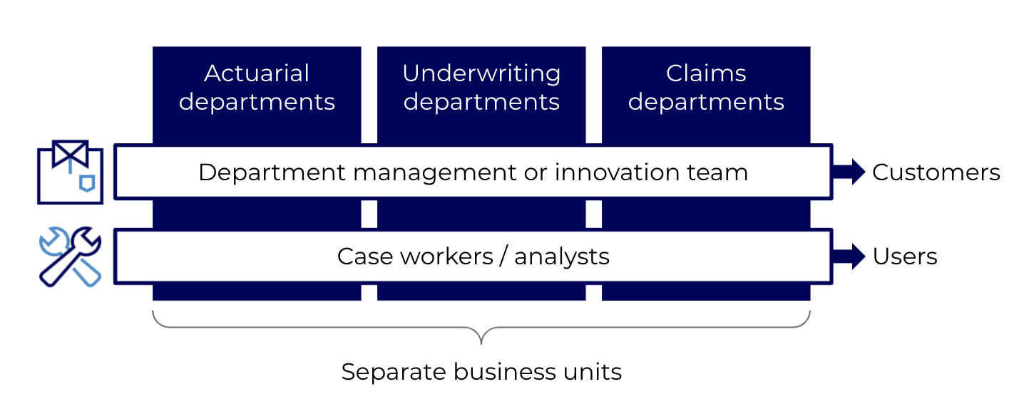
Generally, for all departments the department management or the innovation team is responsible for the acquisition of new services and as such the main customer of our services. As the services are aiming to support the daily work of case workers/analysts they are the users.
The following diagram shows the main customer segments and the subgroups of customers and users within the segments that we have identified for the mining industry:
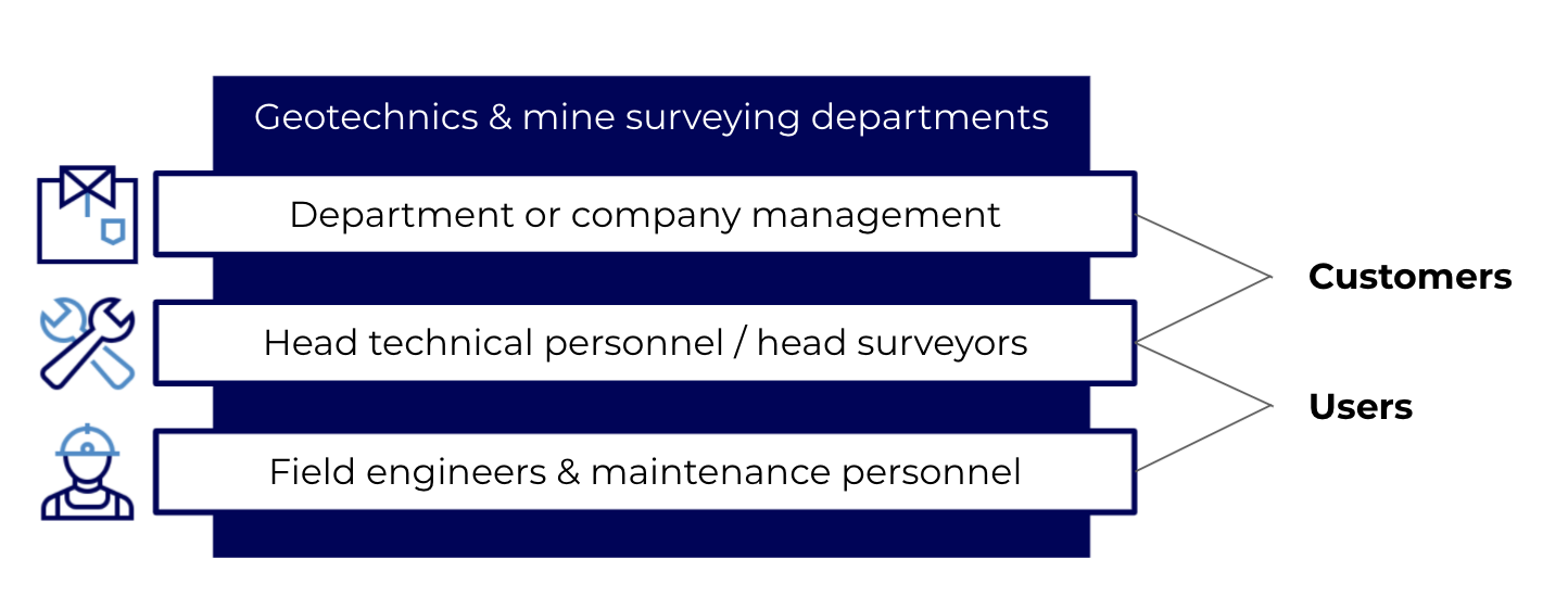
The departments within mining companies that are the main addressees for our envisaged solution are those that deal with work related to geotechnics and mine surveying. In this field, measurements and recordings of mines and the surrounding areas are made in order to evaluate safety and stability of ongoing mining operations and decommissioned mines. Main customer of the solution is the department or company management, whereas the daily users are field engineers & maintenance personnel. Head technical personnel hold a double role as they can use the service for monitoring the maintenance activities on a larger scale, but also have the position to conduct purchasing activities.
Service/ system concept
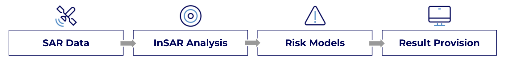
The solution covers the end-to-end process of acquiring SAR data in medium or high resolution, analyzing it using InSAR, identifying risk to assets and providing the results directly to the customer.
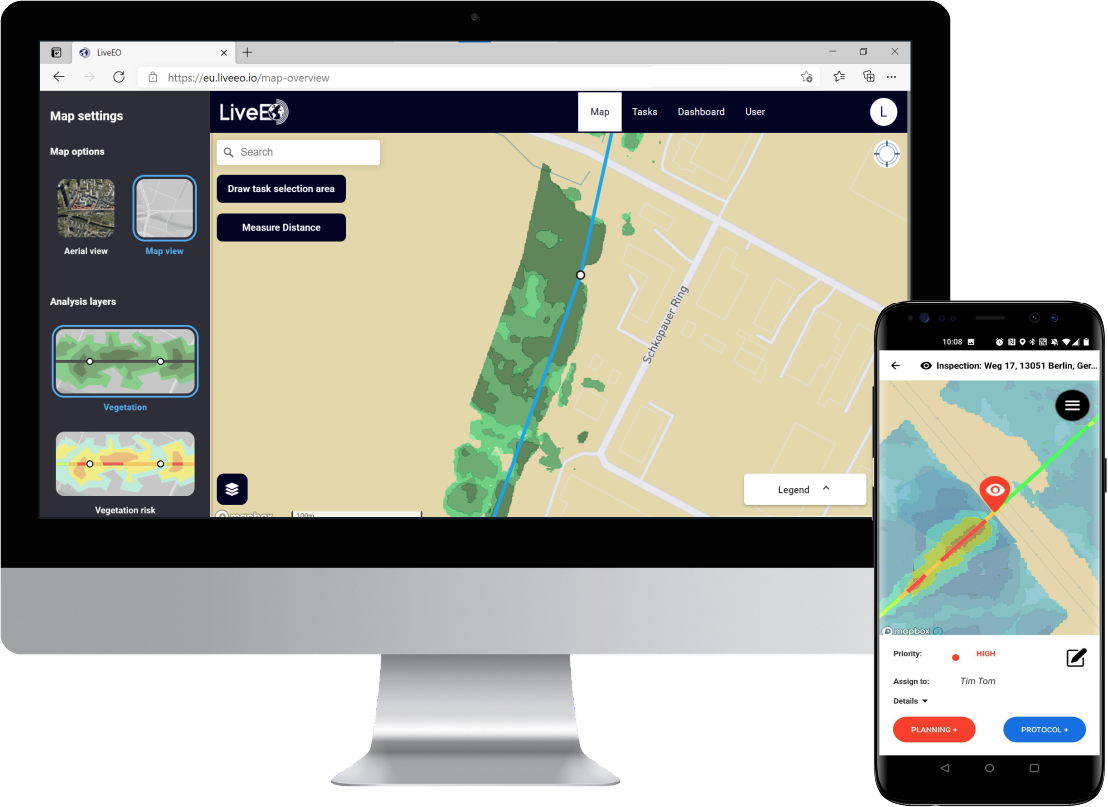
Our insights are delivered in our own web & mobile applications or can be integrated directly into customer systems. The insights delivered this way go beyond the identification of deformation trends and provide actionable insights and alerts when specific assets are at risk. Needs for action are pinpointed and created in the form of tasks, which can be directly used to trigger maintenance, enabling the information created through the analysis of satellite data to directly flow into customer processes.
Space Added Value
With DeMoFloRa, LiveEO aims to take our experience in servicing infrastructure customers and expand our view to new industries. The mining industry and the insurance industry differ significantly in work methods and problems, but are two industries, where utilization of satellite data is not common. In the best case, there are first contact points between the industry and the data, but these are far away from standardized products.
With the KickStart activity we showed that the reason for this are not missing possibilities, but the practicability. In fact, solutions that limit remote sensing to simple data provision and creation of another data pool create little to no significant value for the industries. Therefore, our solutions aim for holistic end-to-end solutions. Based on this concept, we want to offer ground deformation monitoring, which is based on interferometric synthetic-aperture radar (InSAR), but require no remote sensing expertise at the customer side. These solutions can for example help to ensure safety of mines, both operational and environmental, help to categorize insurable assets better or be directly integrated to the claims management. Satellite data offers a way to achieve these goals cost-effectively and with frequent updates, which is why it is an excellent addition to existing methods.
Current Status
In the project, we were able to confirm for the mining market what has been true in our current core offering for infrastructure operators and what is part of our company vision at large: bringing earth observation to enterprise requires the translation of information into insights that customers can directly utilize without a need for expertise in remote sensing, geoinformatics or AI. This is something that not only mining companies themselves can benefit from, but lowered risk in their operations translate into improved sustainability and health outcomes for the environments and communities they are surrounded by.
For the insurance industry, we designed products fitting to the special needs of insurers. Along the value chain, demands and work methods differ significantly. More than for other industries, the creation of a solution requires an extensive co-creation mode, to ensure that a solution is not another vast data source for insurers, but a tool that is directly implementable to the daily work life of the case workers and analysts.