Objectives of the service
Eagle Space aims at the integration of space based capabilities in crisis management to support the joint combat of natural flooding and wildfire disasters. The proposed concept is based on realising a harmonised awareness of the disaster area and emergency operations between the various emergency entities, each working with own methods in a joint combat.
Distribution of the situation on a map is of the utmost importance in the context of an effective emergency response. The net-centric approach is a main objective of Eagle Space. The emergency actors, both behind the scenes and in the field, are connected in a network to share maps of the disaster area and the operations. This contrasts with a traditional system where information goes in a single direction from one dispatching to the field.
Space based services deliver crucial services for emergency situations. First, earth observation data and derived maps provide an essential overview for the different phases of an incident (preparation, response, aftercare). Satellite communication offers the essential possibility to share information in the field in situations where ground based facilities like a classic cellular network are disrupted. Finally, civil people in the disaster area can be alerted using GNSS based alerting services.
Users and their needs
The Eagle Space project targets the crisis management and coordination centres at national level, the safety regions at regional level and the emergency services (fire brigades, police, medical) at subregional level, coordinated by their emergency rooms. The consortium focuses on Belgium and the Netherlands in a first phase.
User needs are collected by means of interviews, meetings and workshops with users and stakeholders. Moreover, the consortium iterates with a soundboard of ‘champions’ stakeholders and users during the different phases of the project.
An overview of user needs includes:
- A shared overview of the disaster situation, including location of mobile actors and assets, between crisis coordination centres and emergency rooms;
- A continuous and reliable ability to communicate between crisis coordination centres and emergency rooms in different regions and between those and the mobile actors and assets;
- The ability to alert civil people in the crisis area, also when standard networks fail;
- The ability to scale up during a developing disaster situation by enabling the introduction of more emergency rooms to the crisis management solution;
- Forecasts about the possible development of a crisis situation;
- The ability to evaluate the crisis after the incident.
Service/ system concept
The yellow items in the Eagle Space architecture depicted below show the elements that are proper to the earth observation service. Specific databases of the service contain the raw satellite imagery and the processing results. In the services layer, different web processing services are added to run fire and flood models in order to generate tailored products for usage in the crisis management systems.
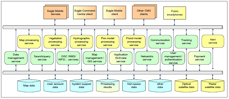
The communication service is extended with connectivity to the selected satellite communication service and interfacing with the antenna and receiver equipment is arranged. The tracking service is extended to be compatible with the PRS equipped mobile devices and possibly augmentation services. An alert service is added, providing the functionality to formulate alerts, coordinate with the Disaster Management Centre and display information on activated alert messages. Further the Application GUI service is extended to support the new functionality of the crisis management client systems. In the client layer the different versions of the Eagle Space or clients crisis management systems are adapted with functionality. In principle, no additional functionality is required for the communication and navigation, apart from the possibility to view status information on the quality and capability used.
Space Added Value
The Eagle Space service supports the crisis management system during all phases of a calamity.
In the preparing phase up-to-date map information and information on the vegetation status and hydrological situation are offered with earth observation based products. These maps are the basis for vegetation and hydrologic models producing fire and flooding risk maps.
During the disaster actual satellite photomaps can be made available and fire and flooding propagation models can be run using actual earth observation information. Using satcom, more reliable communication is provided also when ground infrastructure is damaged to ensure that the netcentric communication is kept alive. The service combines earth observation and satellite communication with secure, reliable and accurate positioning information and access to a GNSS based alert service independent of ground infrastructure.
After the disaster, maps show the situation at the time of the disaster, using the logs of both calamity extensions and crew position. Change detection (damage) products can be generated to make an inventory of the damage.
The combination of the space assets with the netcentric communication platform forms Eagle Space’s unique approach.
Current Status
The feasibility study of the project started in March 2015 and was finalised at the end of 2016. 23 users and stakeholders were interviewed in the Netherlands and Belgium, from which fire brigades, water boards and regional and national institutes were the most important. Current procedures, wishes and ideas for the future were registered.
The service took shape during the service definition that was based on the user requirements and the gap analysis. The Eagle Space service is a common operational picture for the crisis manager, enhanced with innovative fire risk maps, advanced fire spreading models and positioning data of assets in the field.
A proof of concept was worked out by the consortium partners and presented to the user and stakeholder community to collect their feedback. Thorough economic and non-economic viability were performed for our service, to determine its feasibility. Main investments of the consortium into larger markets needs to be performed to ensure the service’s viability.
Main investments of the consortium into larger markets need to be performed to ensure the service’s viability. Therefore, it is currently not foreseen to continue with a demonstration project.
Prime Contractor(s)

Subcontractor(s)