
Objectives of the service

Image credit: OPT/NET B.V., Project: Detecting & Preventing Illegal Fishing.
Illegal, unreported, and unregulated (IUU) fishing is a leading issue impacting ocean sustainability, and characterizing it is challenging due to its clandestine nature. The detection and classification of IUU vessels, especially in the case of small targets, is a point of high interest but it is inherently difficult.
OPT-NET is in an unmatched position to offer a solution to this challenge as its core competencies are in Geo-Artificial Intelligence, Geospatial Imagery Processing and critical infrastructure monitoring. MONITORED AI, an AI powered solution, integrates Synthetic Aperture Radar (SAR) imagery and Automatic Identification System (AIS), providing fishing vessels’ locations on a wide range of temporal and spatial scales.
MONITORED AI is based on an innovative AI data pipeline and has great processing speeds which allows it to detect vessels in large amounts of SAR data, such as Sentinel-1, and high resolution imagery such as TerraSAR-X. Insights derived from the object oriented ship detection model on a representative set of sea conditions, ship types, and geographical areas, can be explored through a user-friendly interface.
Users and their needs
The targeted users are primarily the European Marine Service Agencies and Coast guard authorities. The other targeted user groups consist of ShipCentrics Business Partners in the Marine Industry interested in support of enforcement actions and broader improvements in fisheries governance.
Their needs are as follows:
- Gain geo-spatial analytical skills to use satellite imagery and marine vessel tracking systems (AIS) for the monitorization of massive areas 24/7 for fishing activities.
- Get a tool to automate processes with artificial intelligence to the detection and classification of fishing vessels.
- (continuously) Monitor and record ships actual locations with reported locations, and which methods the fishing boats are using.Quickly acquire alarms on alleged criminal activities.
- Make use of existing assets and data to minimize costs.
- Results in a standardized form for easy exporting and distribution.
The main challenge is to ensure that MONITORED AI can assist organisations by massively increasing the efficiency and speed at which areas in the maritime domain can be monitored, to ultimately produce timely, actionable intelligence.
Service/ system concept
MONITORED AI combines the processing and automation capabilities of AI with the natural problem-solving abilities of humans. MONITORED AI detects patterns in large amounts of EO and AIS data, and flags AI targets for review by human analysts according to the requirement of specific use case of IUU fishing.
Users can rely on an affordable, user-friendly interface to keep track of any changes occurring in the Areas of Interest. For example, using visual tools can explore the list of vessels extracted from Terra-SAR-X and Sentinel-1 inside the Object BBoxes with information about AIS Ship Tracking Data (vessel name, MMSI number and photograph).
MONITORED AI involves a complex analytics pipeline consisting of:
- Composite Geo-images.
- Background suppression.
- Filtering.
- Object Detection and creation of Object BBoxes.
- Working with AIS data.
- Predicting positions.
- Azimuthal correction.
- Cross matching
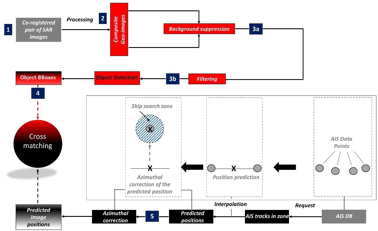
Image credit: OPT/NET B.V., Project: Detecting & Preventing Illegal Fishing.
Space Added Value
MONITORED AI can provide users with the necessary details and reports on their area of interest from combined SAR (Sentinel-1, Terra-SAR-X, PAZ, ICEYE, etc.) with AIS Data.
MONITORED AI can process the AIS data, and allows the SAR images to be used to verify if the reported AIS information is legitimate. The SAR targets can be cross-correlated with AIS Ship Tracking Data and any misalignments are clustered into an anomaly group.
For large and medium vessels, the object oriented ship detection model is able to obtain a high detection result, maintain the ship contour, and suppress false alarms caused by the cross side lobe in the SAR image. For small vessels, the OptOSS model can reduce the number of missed targets, while
also obtaining high detection results, especially for small non-metallic vessels.
Current Status
Currently, a Minimum Viable Product (MVP) has been developed, which autonomously detects dark vessels based on SAR images and AIS Ship Tracking Data. The AI platform is equipped with a powerful cloud based graphical user interface, is focused on being intuitive for all user-groups, facilitates data exploration through visual analytics and removes the data bottleneck of individual analysis ultimately reducing the discovery time.
MONITORED AI presents the following main features:
- A chat-bot assistant to help find documents (raw data as well as analysed data)
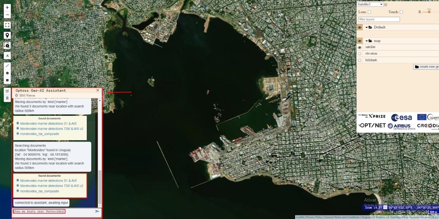
Image credit: OPT/NET B.V., Project: Detecting & Preventing Illegal Fishing
- Visualization of the list of vessels extracted from Terra-SAR-X inside the Object BBoxes, with information about AIS Ship Tracking Data (vessel name, MMSI number and photograph). 19 unmatched and 13 matched vessels can be consulted. Can be selected individually and zoom-in to the respective BBox
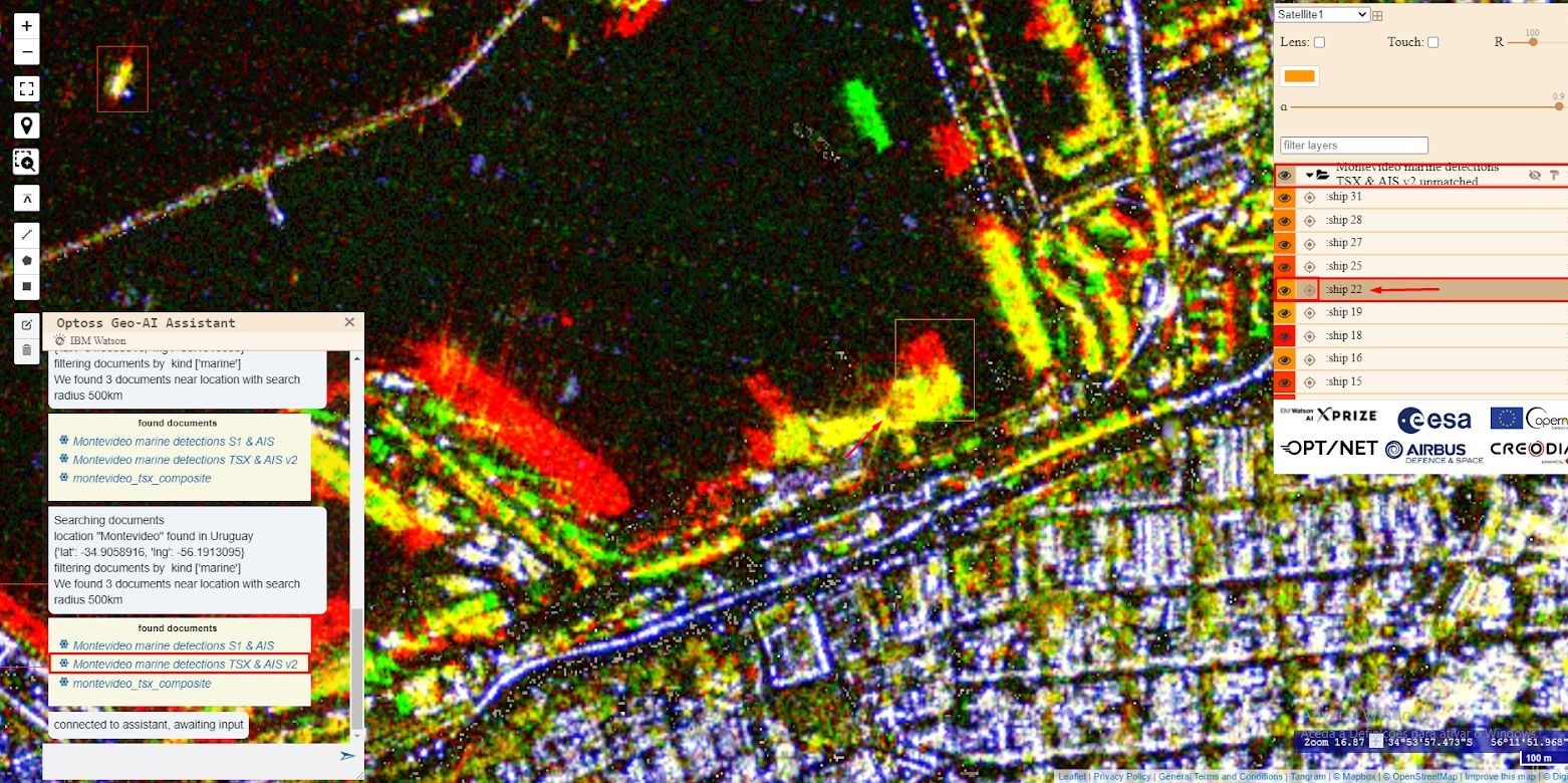
Image credit: OPT/NET B.V., Project: Detecting & Preventing Illegal Fishing
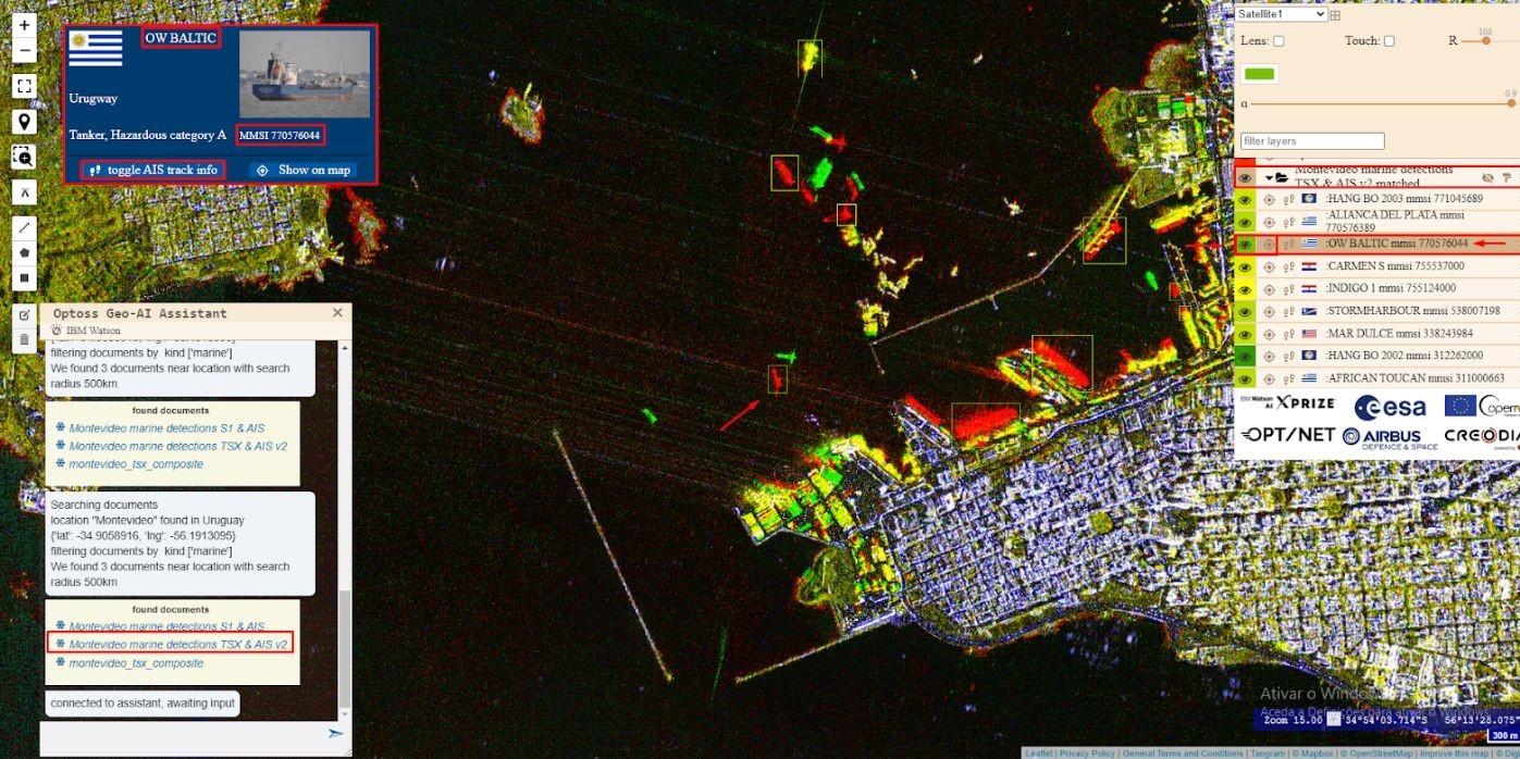
Image credit: OPT/NET B.V., Project: Detecting & Preventing Illegal Fishing
- Visualization of the list of vessels extracted from Sentinel-1 inside the Object BBoxes, with information about AIS Ship Tracking Data (vessel name, MMSI number and photograph). 28 unmatched and 6 matched vessels can be consulted.
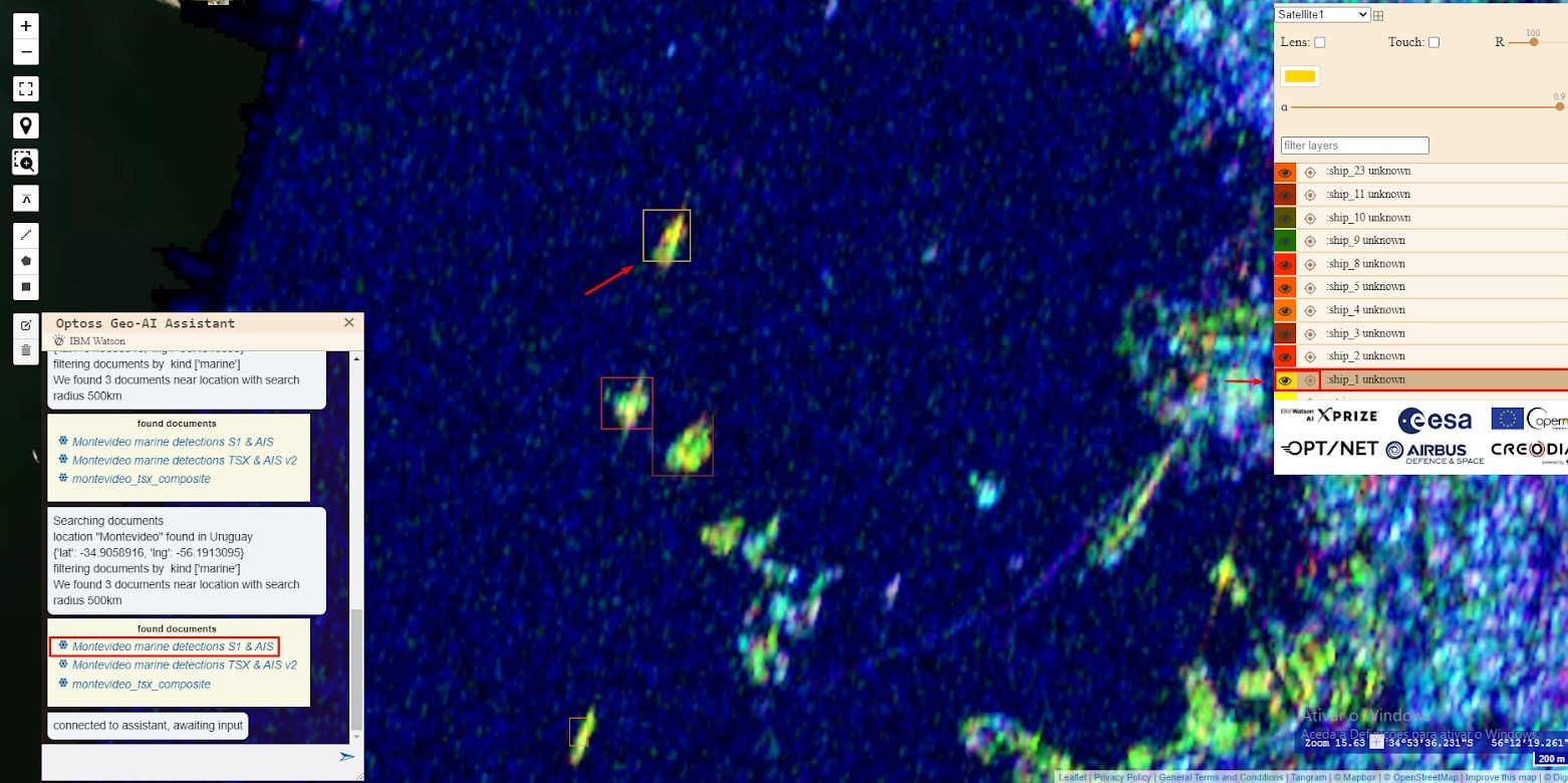
Image credit: OPT/NET B.V., Project: Detecting & Preventing Illegal Fishing
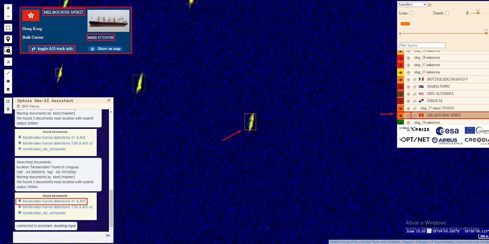
Image credit: OPT/NET B.V., Project: Detecting & Preventing Illegal Fishing
- Zoom/Pan/Draw/Load local file (GPX, KML and GeoJSON)/Measure tools.
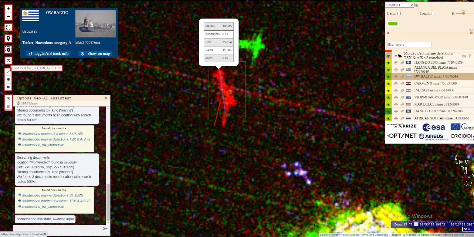
Image credit: OPT/NET B.V., Project: Detecting & Preventing Illegal Fishing


