Objectives of the service
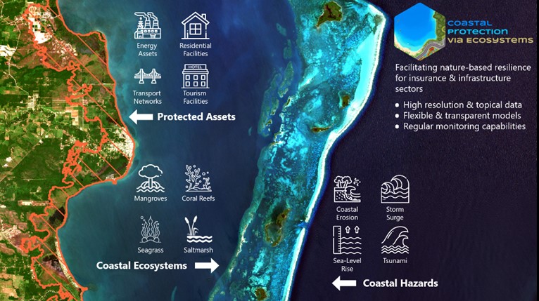
Natural coastal ecosystems such as mangroves, coral reefs, salt marshes and seagrass can substantially reduce exposure and vulnerability to coastal hazards, yet the value of these ecosystems are not fully recognized and they continue to be lost and degraded. The damage limiting potential of these ecosystems is not always evident, as risk managers, infrastructure developers and insurers are not equipped to assess their protective effect on property and assets in their portfolios. The Ecosystems – CPV service seeks to fill knowledge gaps in recognizing and utilizing coastal ecosystems as vital ‘green’ infrastructure for the protection of coastal communities and critical assets. This is done through the use of satellite earth observation data for classification and characterization of coastal ecosystems and through the development of empirical parametric indices for assessing damage limiting potential of these ecosystems. The services will be provided via web-maps with an intuitive dashboard interface.
Users and their needs
The targeted users and customers for the Ecosystems – CPV service include insurance firms, infrastructure companies, government agencies, municipalities of coastal cities and non-governmental organisations involved in restoration and conservation of coastal ecosystems. The key target customers are insurance firms and infrastructure companies, as they are large private sector organisations that have a strong economic incentive and imperative for protecting their portfolio assets against growing climate and nature-based risks. While coastal ecosystems can substantially reduce exposure and vulnerability, providing natural protection from risk, their value as ‘green’ infrastructure is not fully recognised and utilized due to knowledge (data and modelling) gaps. User needs can be summarized as follows:
-
Identifying coastal areas at risk
-
Systematic information on coastal ecosystems
-
Spatial distribution of assets and people along coastal zones
-
Flexible, transparent and user-friendly modelling tools
-
Precise data on ecosystem service benefits
-
Periodic monitoring and evaluation of ecosystems
-
Embedding coastal risks and resilience into asset life-cycle costs
Potential users and customers for the Ecosystems – CPV service are being targeted in the United Kingdom and Australia.
Service/ system concept
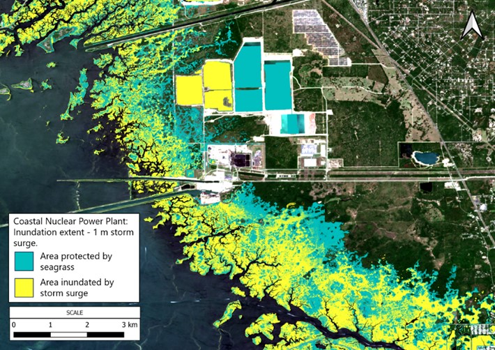
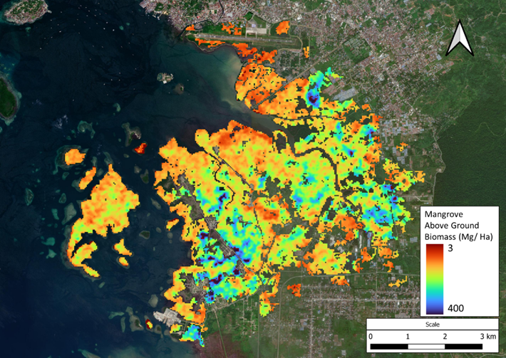
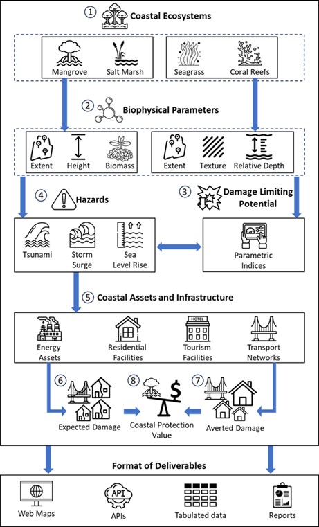
The Ecosystems – CPV service allows users to map the extent of coastal protection provided by mangrove, salt marsh, seagrass and coral reefs ecosystems, under varying hazard scenarios, such as varying magnitudes of storm surges, sea level rise and erosion. This is done through the use of empirical parametric indices that utilise the extent and biophysical characteristics of coastal ecosystems to determine their damage limiting potential. Classification and characterisation of coastal ecosystems are done through the use of satellite earth observation data available at high spatial and temporal resolutions. The service will allow users in the infrastructure and insurance sectors to evaluate nature-based disaster and climate resilience of assets in their portfolios. These services will be provided to users through an interactive web-application with an intuitive dashboard interface, analytical features and web-map layers.
A high level schematic of the service concept is indicated below:
Space Added Value
Satellite Earth Observation (SatEO) plays an important role in the development and deployment of the Ecosystems – CPV service. It is an essential data source used in classifying spatial extents and evaluating key bio-physical characteristics of primary coastal ecosystems that provide coastal protection, such as mangroves, coral reefs, salt marshes and seagrass. This data is vital for determining location, extent and magnitude of protection services provided by these ecosystems. The spatial resolution, temporal coverage and global reach provided by satellite earth observation is unmatched when compared to in-situ or field measurements for mapping coastal ecosystems. The availability of SatEO data allows deployment of the service on a global scale with an assured data quality and availability. Various types of SatEO data allow analyses to be conducted in varying environmental conditions, L-band radar allows mapping of mangroves in tropical belts that experience persistent cloud-cover. Similarly, multi-spectral data allows mapping of shallow submerged aquatic ecosystems, such as seagrass and coral reefs. SatEO data used includes multi-spectral data from Sentinel – 2 acquired via Copernicus Open Access Hub, radar data from ALOS PALSAR acquired via JAXA’s Earth-graphy web-portal, SRTM DEM data acquired via USGS Earth Explorer and land cover-land use data from ESA World Cover.
Current Status
The kickstart study was finalised successfully in November 2023.
Engaged with over two dozen potentials users and stakeholders in the insurance, infrastructure and natural capital sectors to understand user requirements.
Partnerships established with key stakeholders:
-
Ocean Risk and Resilience Action Alliance (ORRAA), multi-stakeholder alliance working in ocean finance, bringing together insurers, banks, governments, academia and civil society, with a mission to drive investment into coastal and ocean natural capital, positively impacting resilience of coastal areas around the world.
-
Earth Security, leading impact advisory firm, working to unlock the value of natural capital through investments in earth’s ecosystems.
Demonstrated efficacy of the service through analyses and projects with both partners.
Presented service at the Ocean Resilience Innovation Forum as part of New York City Climate Week 2023, organised by ORRAA, where service was pitched to over 50 stakeholders, potential customers and investors.
Achieved significant progress in service and analyses outputs, with further process refinement to be achieved through partner engagements and project implementation. Feedback and validation from partners is being sought for projects implemented during the course of the activity. Further service development will depend on continuing customer and user interest and the ability to secure follow-on co-funding.