Objectives of the service
The proposed solution consists in delivering to nearly 1 million 150 thousand people per year (this is only the potential in Poland) selected information on unit prices of sold properties in the vicinity of the place where the user interested in buying/selling a property is located. The user will launch the application on a mobile device in the place where he/she plans to buy/sell a property or on a stationary stand and will have access to analyses of dynamics in the economic as well as geographic area. The main assumption of the proposed solution is to create investment reports based on a selected location (coordinates). The system assumes the use and mutual integration of different sources of data on real estate. Based on satellite data, a spatial evaluation of the attractiveness of a selected real estate location will be performed, while data from scattered real estate sales databases can provide an economic analysis of real estate market supply. Currently, real estate market data is scattered in many private and institutional (public) sources.
Users and their needs
The business model assumes two groups of customers: individual (B2C) and commercial (B2B) - institutions involved in the management of real estate Treasury, developers, investment funds, investment advisers - brokers, valuers, banks - mortgage department (risk assessment). Access to information takes into account the specific characteristics of each group as well as sub-groups of users.
Currently, people making investment decisions in the real estate market (buyers, sellers, advisers) analyse the situation in the market based on:
-
browsing websites with property sales offers - browsing several websites as there is no single global collection of all offers,
-
information from real estate agents and experts,
-
press scrutiny.
Spatial data and especially satellite data and related landscape data are very rarely analysed. The reason for this is primarily the lack of appropriate expertise necessary to process the data. There is no solution on the market that would perform a summary in this regard. This is specialist knowledge. The proposed system can allow the dissemination of this type of information from an investment point of view.
Service/ system concept
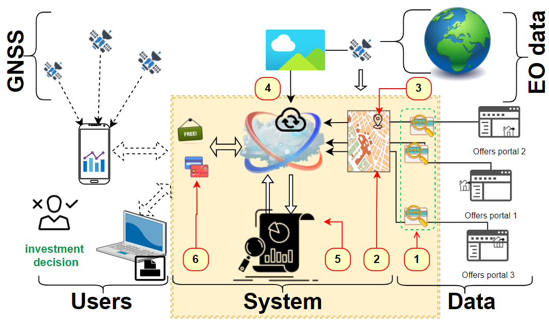
The proposed Estate Market Trends (EMT) system will respond to user needs through dedicated resultant analysis of combined data from: GNSS, EO data and distributed real estate databases.
Forecasted real estate investment returns will take into account the nature of the property and local data. Each investor will have an estimate of future returns taking into account local conditions. For this purpose, algorithms of income approach based on supply and demand trends will be automated. At the same time, locational and environmental information will be implemented into the estimation process.
Space Added Value
The creation of the EMT system will ensure the delivery to the market of a tool that allows real-time tracking of real estate market signals along with geolocation data. A location will be assigned for each sale listing, which will eventually be used in the mobile application. Based on the location and the last viewed property, the system will suggest alternative properties. The use of GNSS systems has become commonplace in the everyday life of the average person. The position determined by GNSS alone is enough to reliably determine the location in space. It will also allow the display to suggest other offers to the customer which are similar in parameters and which meet the customer's needs.
Another very important aspect will be GIS spatial analyses based on satellite data. Observations from satellite missions will make it possible to assess the attractiveness of a location. The location attractiveness of the property itself will consist of information regarding:
-
Weather information from satellite data
-
Information on urban changes (based on satellite images)
-
Landscape assessment of the surroundings (environmental attractiveness assessment)
-
Land cover interpretation
-
Air pollution
-
Actual development
-
Landscape and relief.
Current Status
The focus of the activities to date has been on IT work to find an algorithm to support the target EMT system. In addition, an analysis of competing products for EMT has been carried out, a user needs study and market analysis has been initiated. EMT project activities to date have included numerous consultations and collaboration with real estate valuation experts. Based on these, the main assumptions of the EMT system were designed, along with the required financial analysis. The challenge going forward may be to work on data continuously acquired from network resources related to real estate topics. The challenge going forward may be to work on data continuously acquired from network resources related to real estate topics. However, the developed assumptions and tested solutions offer a good chance of success.