
Objectives of the service
Local administrations continue pushing for cleaner, safer, and more sustainable mobility and use of public space. A powerful approach comes with better management of curb space, being a crucial element of the street and transportation network. However, a staggering fraction of small and medium sized cities continue lacking the basic data and understanding on how the curb is allocated and regulated, either because collecting this data is expensive, time consuming, or technically challenging.
FlexCurb CurbX recognizes that cities can only act on what they know, and understanding curb space should not be such an expensive and time-consuming task for cities to kickstart their curb management. By providing an easy to learn, intuitive, and precise app for data collection, cities will be capable of quickly creating a digital inventory of their curb assets at a fraction of the cost and time.
The use of FlexCurb CurbX is aimed at unlocking more data-oriented decision making for public space, improving coordination and communication between city departments, enabling ultra-local changes of curb regulations, and aligning strategic objectives with tangible interventions to public space.
Finally, having an up-to-date digital inventory of the curb opens new possibilities to communicate curb regulations and changes in a digital and standardized way to citizens and businesses.
Users and their needs
FlexCurb CurbX is targeted to three customer segments in entire European market, which have been identified as being direct or indirect stakeholders in the supply and use of curb space in cities:
-
Public governments and administrations at local level: being the most salient customer segment given their direct role in providing and regulating public curb space. Within this segment, customers can span between multiple divisions, including Mobility, Public Space, Parking, Urban Planning, Economic Development, Smart Cities, Innovation, etc. Their most pressing need is to have access to a digital inventory of curb assets meeting their budget, time, and technical limitations.
-
Consultants supporting cities: consisting of consulting firms working for cities or attached to cities offering data-oriented curb management projects. In such cases, consultants are third parties who may apply their expertise to provide specialized services to cities. In the context of this solution, consultants are interested in using the app to collect curb regulations for the cities they work for in a systematic and inexpensive way. Therefore, their most pressing need is to increase their data collection capabilities, lower collection time, and operational costs of providing their surveying services.
-
Commercial curb users: this segment considers companies who have a financial stake in the use of curb space and are affected by regulations that are relevant to them. More specifically, logistics companies are interested in learning about the location and regulations of loading zones to optimize their delivery operations. Other commercial users include Transportation Network Companies, Taxi companies, and Services companies.
Specific needs for these user segments include:
-
Advancing strategic goals for public space: lower congestion and improve mobility, improve street safety, improve logistics efficiency, and promote economic development
-
Defining interventions to curb assets and regulations that could not be defined before due to lack of knowledge of the curb supply. For example, informing strategic plans and curb infrastructure interventions from curb supply, including: Addition or removal of parking spaces, loading zones, and parking restrictions; Congestion modelling; Economic development analysis; Mobility models
-
Lowering the cost of the data collection and lower the time needed for data collection
-
Digitizing curb regulations without specialized personnel
-
Ensuring accurate digitized curb spaces and regulations for communication and precise analysis
-
Communicating third parties about the overall curb infrastructure supply and its regulations, sharing them in a digital format
Service/ system concept
FlexCurb CurbX consists of a new product of Urban Radar’s FlexCurb portfolio, providing the tools for cities to capture curbside assets and regulations data at ground level. The main components of the solution are:
-
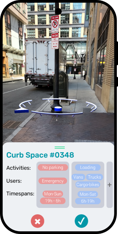
CurbX mobile app, which provides an intuitive interface to survey the precise locations, properties, and regulations of stretch of curb space in a city. The precise registration of curbside assets in space is made through an Augmented Reality interface and Visual Positioning System (VPS), seamlessly transforming the visual positioning of the curb space into highly precise coordinates. Since this approach does not rely on solely on GNSS, submeter precision is achieved, and positioning issues like urban canyoning are avoided. CurbX also supports capturing of highly complex curb regulations, including timespans of availability, authorized user classes, vehicle capacity, etc.
-
CurbX remote infrastructure: after the data is collected by users through the app, the data is sent to the remote infrastructure modules, which process the data to deliver it through a secure API, which cities can consume or plug-in to FlexCurb Planning (Urban Radar’s platform for curbside management). Part of this processing includes generation of linear referenced geometries, and verification of curb positioning, using up-to-date and Very High Resolution SatEO imagery. The result is a secure API to deliver the digital curb space inventory data using the Curb Data Specification (CDS).
Space Added Value
The use of SatEO makes the data collected through FlexCurb CurbX more accurate, reliable, and detailed, enabling analysis, communication, and presentation of a digital space inventory both at internal level in municipalities and at external level with the citizens.
The solution makes use of submeter Vey High Resolution Satellite Earth Observation (0.3m – 1m) as a method for data collection verification and enrichment. The remote infrastructure of the solution compares features extracted from SatEO with the geospatial data collected from the app, removing potentially systematic errors in geolocalization by matching the curb assets with the observed public space. This method also allows enriching curb location data, since the app only collects simple anchor points as it would be too time consuming to collect the detailed geometry of curb spaces. By matching the anchor points with features of the imagery, it is possible to transform simple points data into polylines or polygons that better represent the geometries of the curb spaces.
Current Status
The Kickstart Study for the proposed technology solution has successfully completed. The Final Review meeting was held to present the main deliverable, which demonstrated the service, technical, and economic feasibility of the solution. The following key findings were highlighted:
-
Service feasibility: The service has been informed through several interviews with potential customers and has been defined through the identification of user, service, and system requirements.
-
Technical feasibility: A technical architecture of the solution has been specified, providing a clear understanding of the solution components and how they will interact, including the use of Satellite Earth Observation as a key asset offer the value proposition.
-
Economic feasibility: The market has been assessed, evaluating business potential of the solution in European markets, revealing promising results.
-
Commercialization strategy and roadmap: A commercialization strategy and roadmap has been specified for a potential continuation towards implementation. This includes the steps required to bring the solution to market, including business modeling, market entry strategies, and potential steps for continuation.
Prime Contractor(s)