Objectives of the service
Floating-leaved aquatic weeds can rapidly clog up lakes, reservoirs and navigation canals, leading to major economic impacts for businesses, fisheries and leisure activities. Their growth and spread is a particular problem in freshwaters in tropical and sub-tropical regions. As free-floating weeds can move rapidly with winds, providing a frequent and complete picture of their coverage across the whole waterbody surface is key to inform boat access and target weed control programmes. Frequent updates also provide early warning of weed problems in new locations.
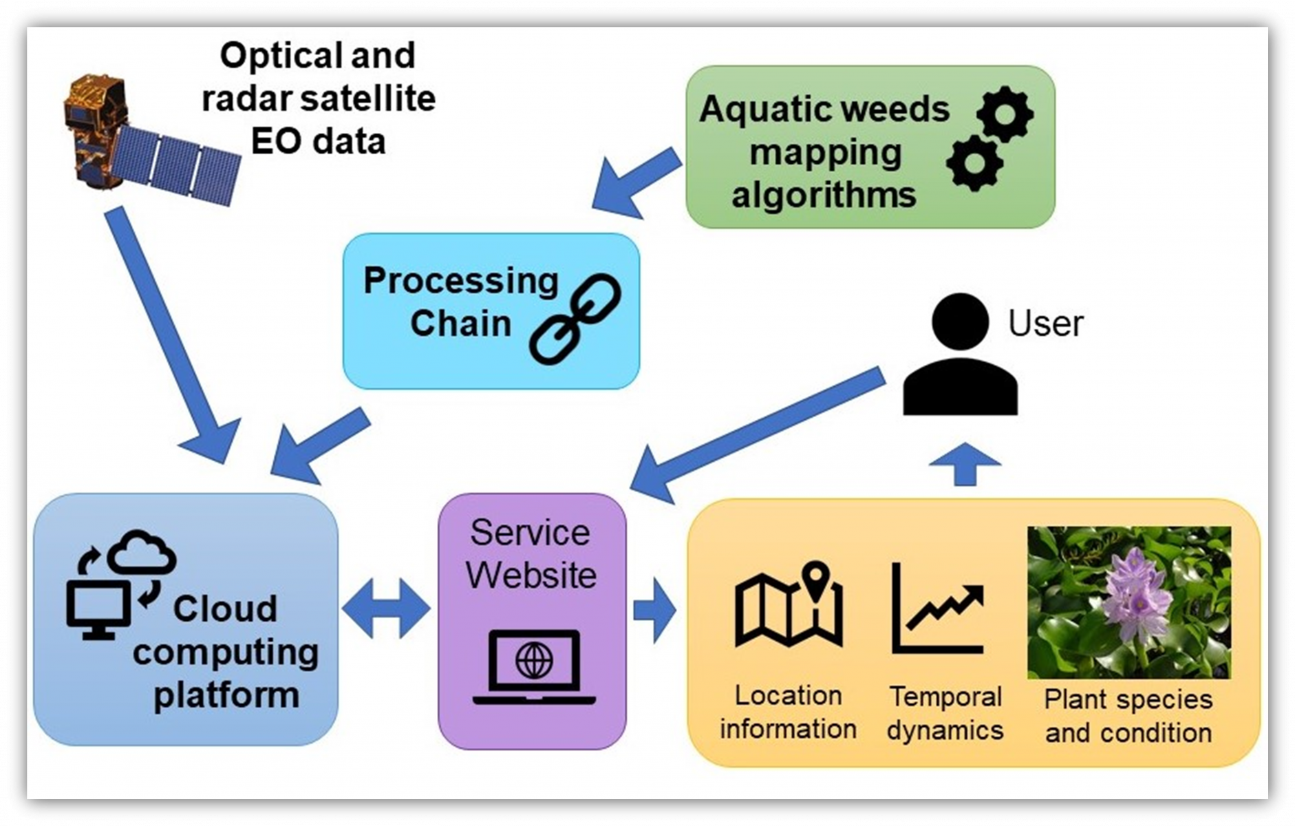
Currently, surveys of floating weeds are carried out from boats or helicopters. The service will supply weekly maps and metrics of free-floating weeds using a combination of radar and optical images from ESA Sentinel satellites. Floating Weed Manager will be a web service that offers customers across the globe a range of products supporting enhanced weed management programmes.
The objective of this project was to investigate the technical feasibility and economic viability of the Floating Weed Manager service.
Users and their needs
The targeted user communities are primarily national or regional agencies tasked with overseeing and managing weed control programmes (Customer Segment 1). A typical segment 1 customer will be obliged by legislation, as well as necessity, to control floating weeds, e.g. our champion customer, the US Army Corp of Engineers, (USACE), Florida, USA. Users also include regional administrations that strategically manage water bodies within their area, this includes city or state level organisations; e.g. Biosecurity Queensland, Australia. The service will provide them with up-to-date weed cover maps and statistics to effectively target their weed management programmes.
Segment 2 customers /users include external consultants that give advice on controlling weeds and carry out weed control programmes, such as The Center for Aquatic and Invasive Plant Management, Florida, USA; CABI Kenya; and Rhodes University, South Africa.
Segment 3 customers are users that access water bodies for recreation or work; for example, commercial and recreational fishermen, water sports businesses or enthusiasts. By accessing weed cover maps, these users can identify when and where their water bodies are accessible.
The challenge for the project was to be able to distinguish free-floating plants from emergent vegetation and provide map updates at a high frequency (weekly).
Service/ system concept
The service aims to deliver the following products and information to customers through a web portal:
- Maps of free-floating weed coverage at 10 x 10 m resolution, updated at least 3 times per month, for whole waterbodies or regions specified by the customer. Dependent on cloud cover, higher frequency map updates will be provided using optical satellite data.
- Summary measures of floating weed coverage for whole waterbodies, or regions specified by the customer, updated at least 3 times per month.
- Visualisation of time series of coverage for whole lake or specific sectors specified by the customer.
- An online web portal for customers to access and download current and past maps, data and metrics.
- Analysis of weed population changes in specified sectors in response to control programmes.
- Expert support and interpretation services to support weed management programmes.
- Access to local weed control and management experts (where relevant).
Radar data will be used to deliver dependable weed maps, unaffected by cloud cover, at approximately weekly frequency. Optical data will supplement that to provide a higher frequency of survey and help differentiate floating weed species from emergent vegetation and potentially measure flowering and plant health. The Service will create a processing chain that delivers products on the website within a day or two from receiving the satellite data.
Space Added Value
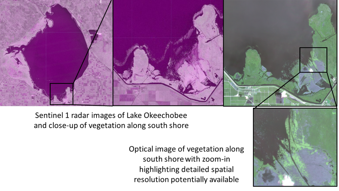
Currently surveys of floating weeds are carried out from boats or helicopters, typically surveying whole lakes at a monthly frequency at best. The service will use a combination of ESA Sentinel 1 radar and Sentinel 2 optical images. Combining these two assets, the service will supply more comprehensive and more frequent (weekly) vegetation maps than existing “ground” surveys and provide enhanced quantification of weed population coverage and weed health. The service could also incorporate optical imagery from commercial satellites (e.g. Planet) to provide finer spatial resolution (3 x 3 m) and higher frequency updates.
Current Status
The study started in August 2020 and was completed in April 2021. The project held four regional workshops in the USA, South Africa, Kenya and Australia, followed by online surveys, to understand current monitoring approaches and customer needs for a service.
Technical feasibility has been tested using ground truth data from Florida, USA and from this an achievable service meeting user requirements was finalised. Example products have been developed for our Champion Customer’s main waterbody of interest, Lake Okeechobee, and sites in South Africa and Kenya, to highlight the spatial resolution of satellite data (see figures below) and the temporal frequency of image availability in different regions.
Commercial business viability has been evaluated using a number of tools (Business Model Canvas, SWOT) evaluating the external business environment and costs of running a service.
A Proof of Concept web portal was developed to illustrate the service and this has been evaluated by customers in our case-study regions.
From all these activities we have now completed the Business Case and Proof of Concept reports and the Final Report summarising the project outcomes.
Prime Contractor(s)
Subcontractor(s)