
Objectives of the service
In the current context of climate change and biodiversity loss, sustainable forest management has become a crucial challenge. At local, regional, and national levels, forest management has environmental, economic and social implications. The high-performance monitoring services offered by SPACEBEL help authorities, industries and private owners to improve their forest management practices.
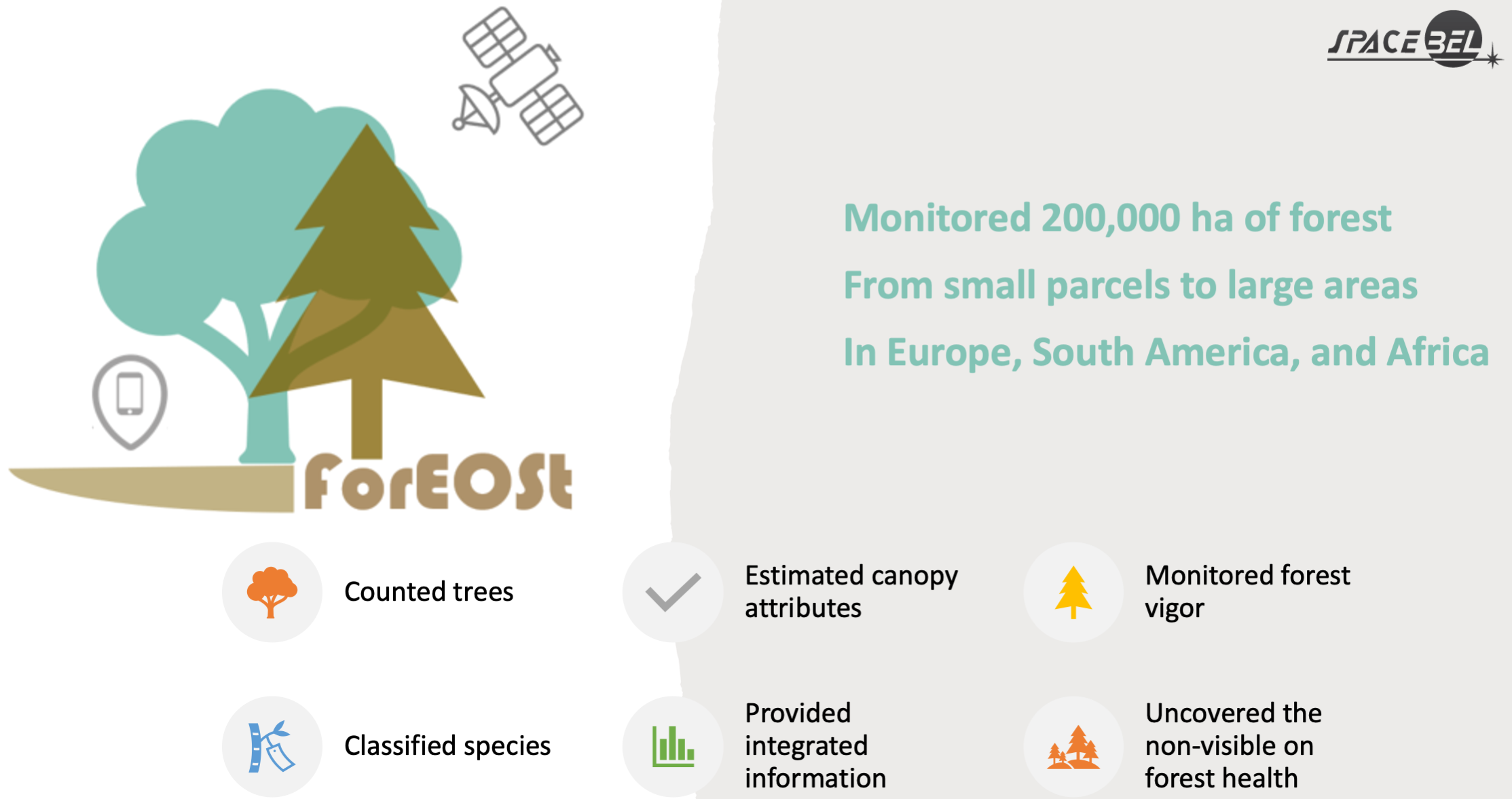
Through the collection and analysis of satellite and airborne data combined with field information, SPACEBEL offers a range of products and services designed to help clients better understand changes occurring within forest ecosystems. From analysis-ready datasets to detailed geospatial and temporal analytics, SPACEBEL supports species inventories at various levels as well as forest change detection due to logging, disease outbreaks, etc. This provides a deeper understanding of the impacts of changes on forest ecosystems. In practice, ForEOSt offers different levels of services, based on SPACEBEL's expertise in geospatial data processing.
Users and their needs
SPACEBEL caters to the needs of those passionate about forests and urban trees by supporting forest management associations, forest authorities, forest owners, forest service companies, and forest industries.
Users require dynamic forest inventory and monitoring services that are accessible through an easy-to-use, industry-specific web-based application. SPACEBEL understands the importance of sustainable forest management and is committed to providing innovative solutions to meet diverse user needs including forestry companies that require the ingestion of data in their platforms.
Service/ system concept
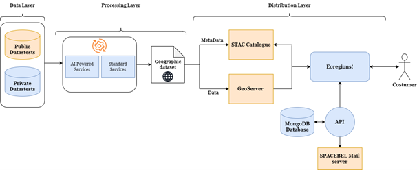
ForEOSt exploits the power of EO data to provide seamless digital solutions to customers. It includes a three-layered architecture of Data, Processing, and Distribution to allow for a smooth and precise delivery of the services based on a costumer’s request.
The services are divided into two categories, the standard services available world-wide and the AI powered services that are based on high-performance deep learning models and are designed for a selection of prioritized regions and tree-species.
The data and the corresponding metadata are distributed via a Geoserver or zip and STAC catalogue allowing a smooth delivery.
Space Added Value
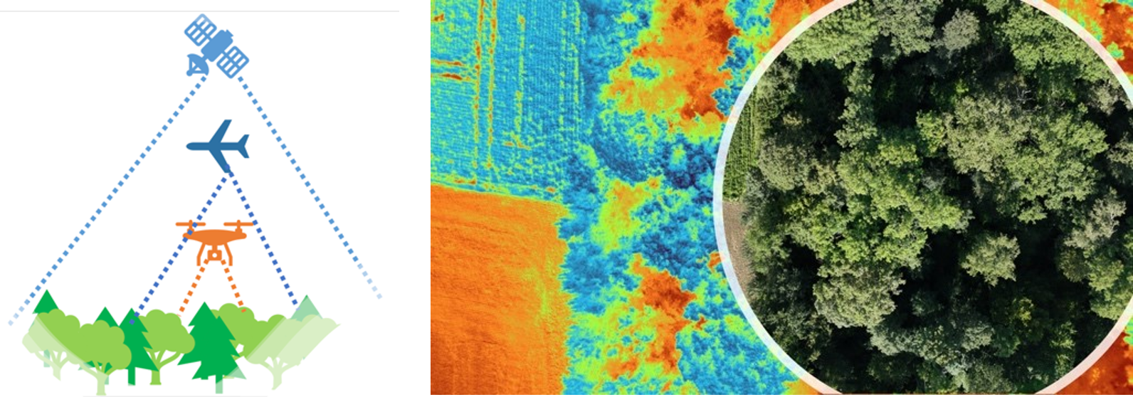
Satellite images are integral to ForEOSt’s services
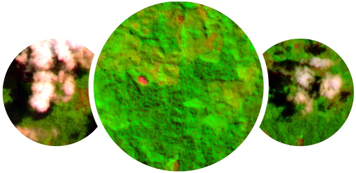
- The value of multispectral imagery: with bands in the visible and infra-red parts of the spectrum, satellite data such as those acquired by Sentinel-2 imagery monitors the natural environment. SPACEBEL unlocks the spectra provided by such multispectral systems by leveraging all parts of the electromagnetic spectrum to upgrade forest surveys. SPACEBEL's services reveal the invisible to the eye and provide a broader perspective of biotic and abiotic disturbances.
- The value of continuous imaging: many areas in the world suffer from persistent cloud cover. Creating monthly cloudless mosaics of images is invaluable for effective forest management as it provides a consistent view of the forest canopy. SPACEBEL provides an easy to access flow of consistent and high-quality mosaics for forestry experts to integrate into their systems and workflows.
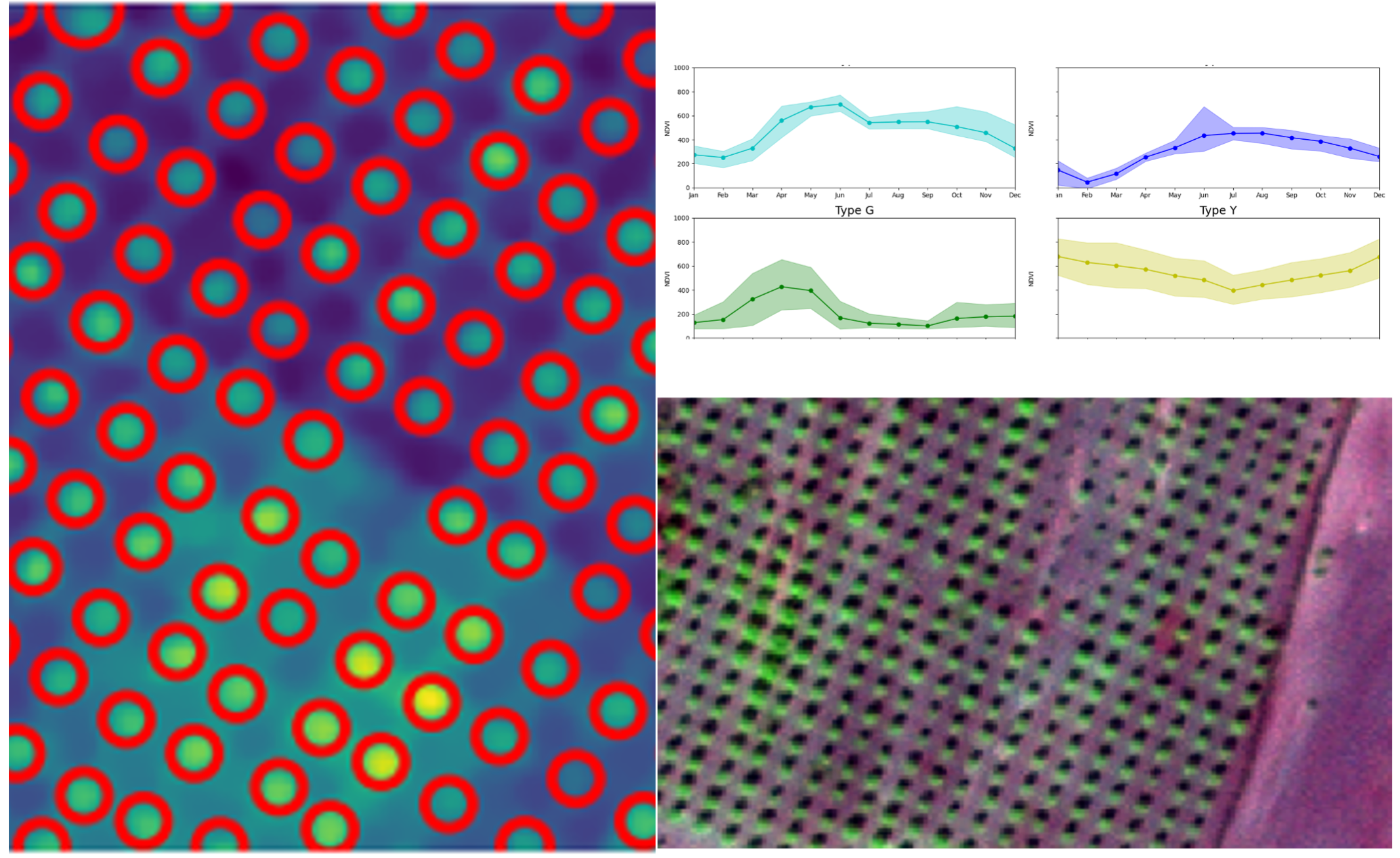
- The value of spaceborne repeatability and time series: regular and repeatable acquisition of satellite imagery provides a valuable resource for tracking forests and urban canopies and assessing their vitality status.
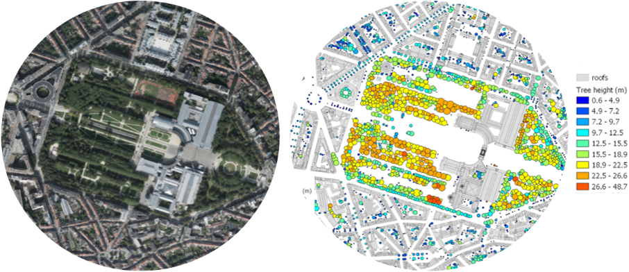
- The value of very high-resolution data: by using very high-resolution imagery, Earth observation data can identify tree density, tree height, or count tree crowns in urban and agricultural areas. This is essential for urban management, planning, and conservation efforts, helping cities to optimize green spaces and promote healthy environments. It also ensures that plantations are productive, sustainable, and environmentally responsible.
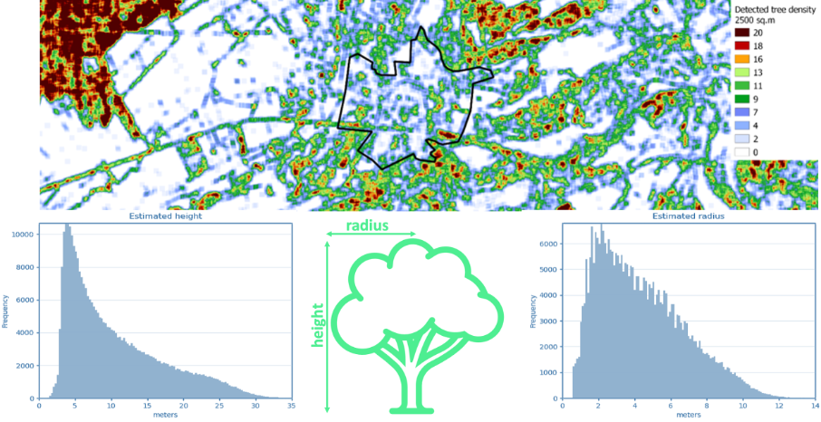
- The value of large coverage and data integration: large coverage of satellite data is indispensable for preserving the health and integrity of remote forests and urban canopies in our neighbourhoods. Such coverage directly supports forest protection and monitoring, facilitates accurate forest inventory and the assessment of ecosystem services, and supports sustainable management practices.
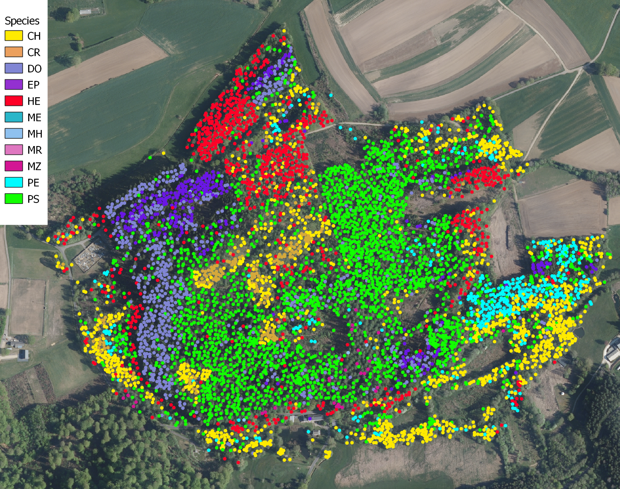
- The value of unlocked advanced data analytics: satellite data unlocks the potential of advanced analytics that highly support forest management. For example, mapping tree species explains species interactions and ecological roles. It also enables targeted conservation efforts and the planning for mixed forests that are more resilient. Such analytics directly support forest protection and monitoring; they also facilitate accurate forest inventory and the assessment of ecosystem services.
Current Status
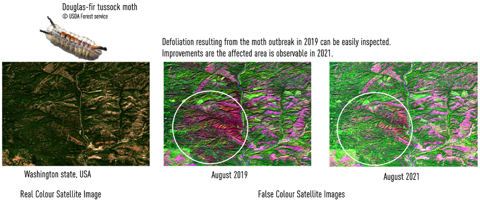
The kick-off meeting took place in May 2022. We have collected user needs and provided data to our project partners for regions in Europe and in South America. Through the pilots carried out with partners, we have analysed and interpreted various datasets. Through a contractual change, the project was extended till end of 2024 to allow for further adaptation and validation of the services as well as improve the system Integration and validation. Finally, building on the pilot experience, further efforts related to business development were planned.
ForEOST has also established a great collaboration with Timbtrack, an early adopter of our services. We are grateful for Timbtrack’s visionary spirit and pioneering role in embracing innovation, catalysing progress, and shaping the future of our digital landscape. You can now order our services through Timbtrack’s platform by visiting EORegions! Portal or directly contacting eoservices@spacebel.be).

Prime Contractor(s)
