Objectives of the service
Forests from Space aims to transform the existing agroforestry model. It revolutionise remote planting supporting Treedom, the first company to allow users to plant trees for themselves or virtually gift them to someone else, to additionally offer:
-
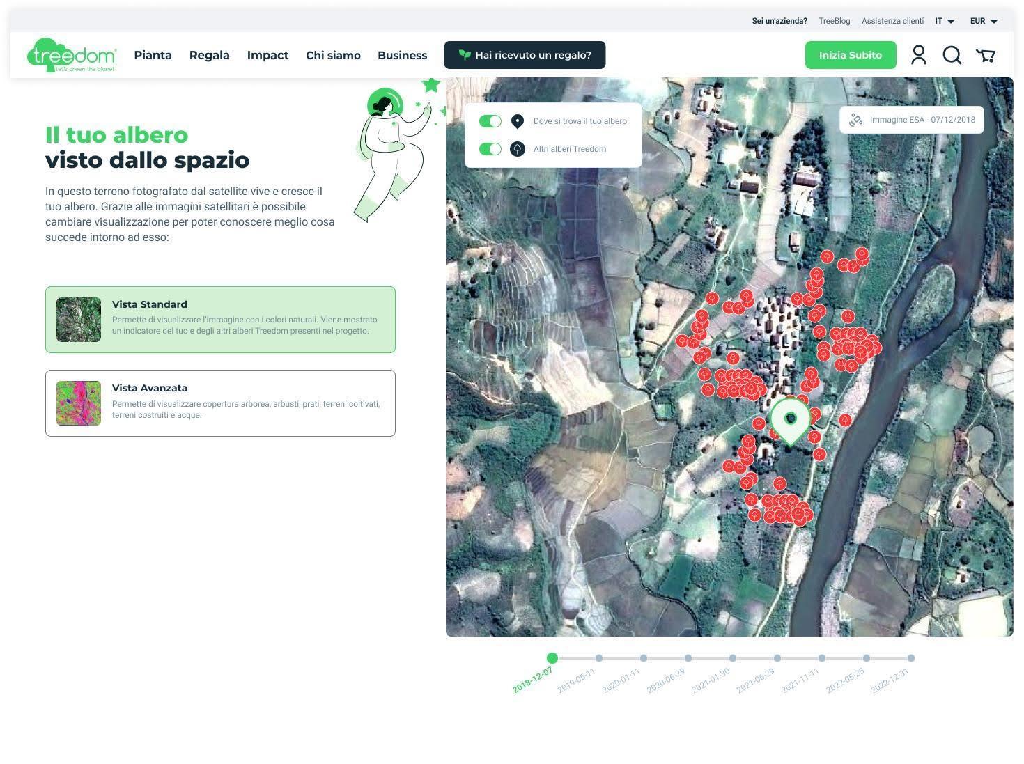
improved follow-up by providing the user with an updated picture of the plot where its tree is planted at least once a year;
-
monitoring and transparency reassurance by adding georeferenced data to the picture of the tree's plot;
-
reduce room for error and delay in logistics, which rely on the farmer community of the forestry team; and
-
a data recollection service for environmental purposes that complements the company's portfolio and improves Treedom's value proposition by providing extra monitoring and support in the selection process of new areas to start agroforestry/forestry activities. Geospatial photos provide information on the environment's status, the area's optimisation, and information regarding water sources, among others.
Users and their needs
Treedom users are both private customers and companies distributed worldwide with a greater incidence in Italy, Germany, Benelux, UK, France and Spaina.
Users showed some basic needs:
-
increased input and feedback over time regarding the status of their tree or the specific area in which it is planted;
-
increase opportunities to interact with their tree and the project in which it is included; and
-
receive more data with respect to the environmental impact that their tree and the agroforestry project in which it is located is having;
-
further elements of traceability and transparency, information also coming from third parties and not only from the company.
Service/ system concept
As consumers purchase the service and follow-up is carried out exclusively online through Treedom’s website, it is imperative to constantly offer added-value services and expand the content available on the platform.
Therefore, Forests from Space seeks to transform the existing agroforestry model and revolutionise remote planting by being the first company to allow users to plant trees for themselves or virtually gift them to someone else and additionally offer:
-
improved follow-up by providing the user with an updated picture of the plot where its tree is planted at least once a year;
-
monitoring and transparency reassurance by adding georeferenced data to the picture of the tree plot;
-
reduce room for error and delay in logistics, which rely on the farmer community of the forestry team and are carried out manually; and
-
a data recollection service for environmental purposes that complements the company's portfolio and improves Treedom's value proposition by providing extra monitoring and support in the selection process of new areas to start agroforestry/forestry activities. Geospatial photos provide information on the environment's status, the area's optimisation, and information regarding water sources, among others.
Space Added Value
Earth Observation (EO) is the space asset that is subject for integration into the existing operational system. EO plays a crucial role in monitoring trees and forests due to the following main characteristics:
-
global coverage: EO satellites provide a consistent and comprehensive view of the Earth's surface, enabling monitoring of trees and forests in remote and inaccessible areas;
-
timely and consistent data: EO data is collected regularly and consistently, giving the opportunity to track changes over time. This helps in identifying trends (e.g.: deforestation, tree growth) and effects events (e.g.: wildfires, floods);
-
possibility to monitor vegetation health status: the analysis of optical multispectral data can provide information about vegetation health status through the analysis of spectral vegetation indices.
Thus, the integration of EO-based services can improve Treedom’s ability to:
-
analyze and monitor the condition of the land cover in correspondence with the trees that have already been planted or are to be planted, even if Treedom’s projects are fragmented because trees are mainly planted in small plots belonging to individual smallholders;
-
map forest extension around the tree site of interest;
-
identify potential new areas for developing agro-forestry activities and/or more suitable tree species.
Current Status
Use photos, maps or screen grabs in this section.
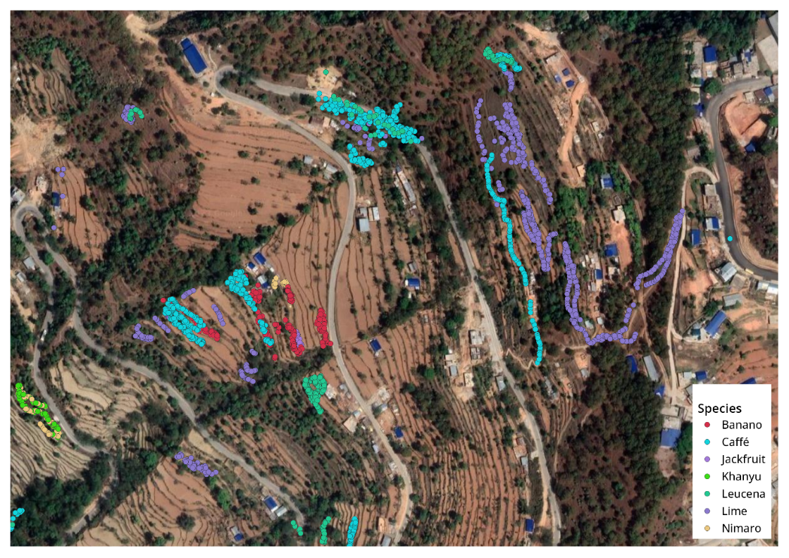
Image credit : Planetek, project Forest from Space
For the project as been completed
-
Customer Identification & Value Proposition Definition
-
Technical Feasibility Assessment
-
Commercial Viability Assessment
For the Proof of Concept
-
identification of Areas of Interest (AOIs) to be used as test areas for EO data retrieving, processing and output generation;
-
identification of relevant EO data;
-
Creation of a service mock up;
-
Survey for 20K users and clients on the new service futures.
After the proof of concept and its positive results we have conduct another analysis concerning the use of multitemporal and hyperspectral data.
-
Hyperspectral sensors, thanks to their high spectral resolution, are able to acquire within very narrow and contiguous wavelength ranges, named bands, and represent valid instruments for vegetation health assessment.
-
Use of multitemporal data. The goal of this service is to provide a chart that shows the health evolution trend of the vegetation within the tree plot, according to quarterly time intervals. The graph will allow us to visualize the evolution trend of the vegetation health status over time as a function of “vegetation health” classes.
With these new elements and considering all the projects outputs partner have released the service implementation plan.