Objectives of the service
The objective of the project is to meet the growing needs of anglers by proposing a mobile application dedicated to anglers, using modern IT, satellite, geoinformatic and communication tools. The designed application could become a common tool used by anglers, people involved in aspects of sport fishing, water reservoir managers, as well as companies and institutions dealing with fishing tourism. The project aims to develop the basis for building an application that uses the augmented reality (AR) technology designed for the fishing environment. The FSARG application relies on the use of integrated data on the depths of fishing grounds with current information on species and quantities of fish present in a given water reservoir. The local weather information can also be available for the users. An additional module of the application is a social part, thanks to which it can be possible to communicate groups of anglers in individual fisheries, exchange of information on fishing, organization of joint expeditions, contests, challenges, etc.
Users and their needs
Increasing use of modern IT and communication tools by our society is an important information for the fishing sector about the possibilities to use these techniques for angler market. The anglers are not in the vast majority attached to one lake. The decision to change the water reservoir depends primarily on the abundance of fish. The angler would like to have as much information as possible about the water and its surroundings and the fish that they would like to catch (especially larger ones). Our mobile FSARG application offers anglers the information about the integrated depth data of fishing grounds. With the benefits of GNSS and virtual reality it gives completely new level/standard of modern fishing. Thanks to the integration of accurate GNSS satellite positioning with bathymetric data, it is possible to properly locate the best fisheries according to the preferences of the angler. Anglers are the main target user group for proposed application. The second group of potential users and service clients are the institutions/persons managing water reservoirs. The third group of recipients could be companies and institutions dealing with tourism, in particular fishing tourism.
The application is developed in Poland, but it can be extended to other European countries.
Service/ system concept
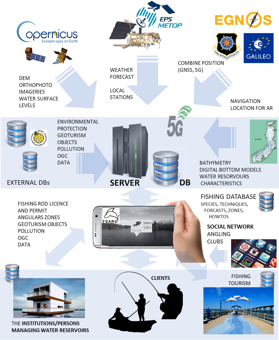
The FSARG system architecture consists of a mobile application cooperating with a server that processes data acquired via EO and Satellite Navigation. The processing module performs operations to process the data needed to collect information about the shape of the bottom of the water reservoir. The FSARG system receives processed data from the processing module, which depends on the Satellite Navigation data. The application processes and provides output information to system users. In general, FSARG requires internet access, however due to possible technical difficulties related to the deployment of telephone/internet masts in the rural areas, it is necessary to take into account the possibility to download Internet data before the planned use of the application in the field. Thus, the EO data is processed on the server without the mobile device, while the satellite navigation data is processed and used in real time. This solution allows to provide the detailed information about the depths of the fishery (using AR technology), indicate interesting for the angler fisheries, transfer relevant information to other FSARG social module, forward any relevant messages to fisheries managers and relevant services.
Space Added Value
The project is based on two key programs implemented by the European Space Agency (ESA) on global satellite positioning systems (Galileo and EGNOS) and the Earth observation program (EO) - Copernicus. The proposed solution envisages the use of bathymetric, ichthyological, environmental and tourist database synergies with the European satellite navigation systems and Earth observation data in order to provide users with integrated, reliable and relevant information.
The use of modern and accurate satellite GNSS systems and GNSS augmentation systems – European EGNOS allows the addition of new functionalities related to, among other things, determining the exact position of the user, determining the optimal places for the given season of the year and day on a given fishing ground, navigation to optimal places of fishing at a given time, checking the shape of the bottom with the help of augmented reality (AR) or obtaining information about catches of other anglers in a given location. The possibilities of using Earth Observation data (EO) to determine the depth of water reservoirs using the Satellite Derived Bathymetry (SDB) method is one of the objectives of the project.
Current Status
The full version of the FSARG application will offer the following functionalities:
- depths of fisheries in the form of digital bathymetric maps,
- information on the locations of individual fish species in a given fishery at a given time of year,
- the ability to keep a fish catch register,
- the possibility of reporting irregularities in fisheries,
- information on difficulties in fisheries (provided by fisheries managers),
- information on available parking spaces at the fisheries, boat launching places and access to the fishing grounds,
- fishing social networking site with the possibility of creating groups of friendly anglers exchanging relevant information.
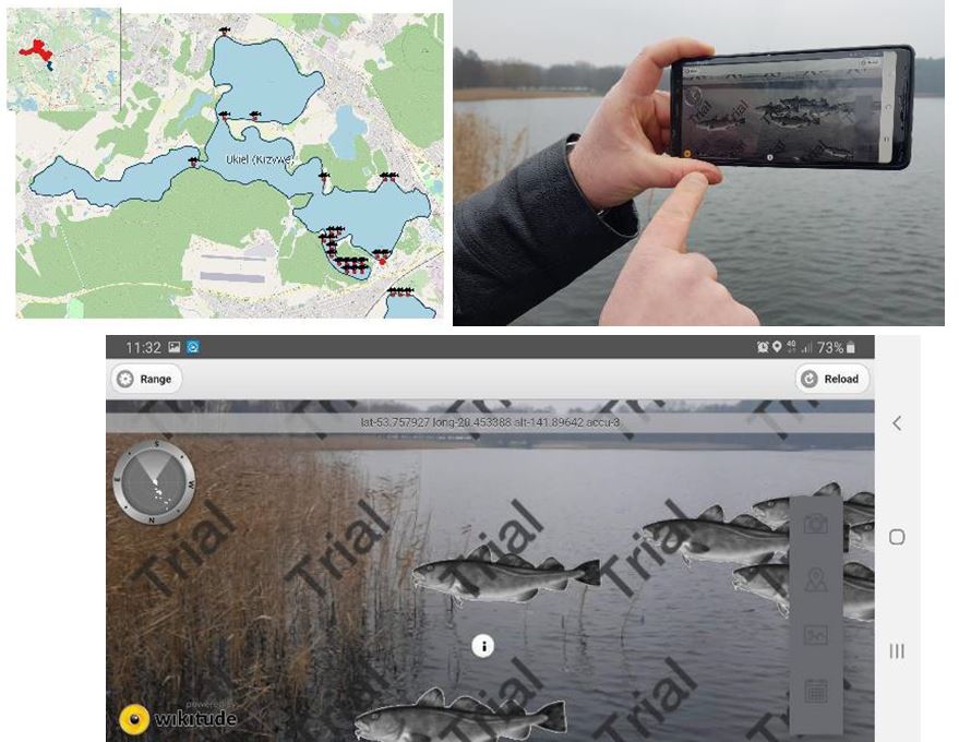
Practical tests of FSARG were carried out on two lakes located in Olsztyn.
Tests concerned the correct operation of the initial version of the FSARG application. A Samsung Note 8 mobile phone was used for testing, this model is equipped with all necessary sensors for AR visualization. Some examples are presented in Figures below: