Objectives of the service
The aim of this study is to assess the technical feasibility and the commercial viability of an integrated solution to provide the insurance sector with the ability to better assess ground instability issues. The current objectives are:
- Explore existing resources from both ground and satellite sensing technology suppliers to provide a service.
- Establish a supply chain capable of delivering this service.
- Determine a need for a commercial service for a select user group.
- Establish a roadmap for the development of a demonstrator prototype.
Subsidence due to clay shrinkage is the largest ground instability issue affecting residential property in the UK (75% of all valid insurance claims) with rectification costs averaging £250m (295m Euro) p.a. Research by the insurance sector (Swiss RE and Lloyds of London) indicates that the extent of subsidence both in the UK and Europe will worsen in line with climate change forecast. The insurance sector equally recognizes the need for significantly improved profiling and predictive tools to identify and target risk mitigation management.

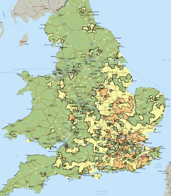
Subsidence risk distribution in England and Wales - Note green = low, amber = medium, orange = high and red = very high.
Users and their needs
The target users are all keys disciplines within the UK residential property insurance market, namely insurance companies, re-insurance companies, actuarial service providers, brokers, risk managers and subsidence management claims providers.
In addition, there are also the following areas of identified opportunity:
- Transfer of knowledge into non insurance markets such as Housing Associations, Councils, facility managers, commercial arena lending and conveyancing
- European and International markets.
The User Groups are looking for a cost effective manner in which to increase knowledge of the areas of subsidence risk in the UK.
Any initiatives that provide more certainty, reduce overall claim costs, reduce timelines and enable customer focused solutions to be developed will attract significant interest from the insurance community.
Service/ system concept
There will be a number of modular service options that GIRP will deliver to the UK residential and SME property insurance market - based upon operational areas of the insurance industry:
- Risk profiling and mitigation management
- Underwriting and premium setting
- Claims management
These are all based and built from a new and unique Core Subsidence Hazard Score. The GIRP core subsidence hazard score is derived via the weighted integration of relevant input datasets.
Space Added Value
The extent of monitoring ground movement and the triggers across a significant geographical area and the need to convert a ‘static’ profiling tool into a predictive service lends itself significantly to the application of satellite technologies.
InSAR data can track wider area changes in ground movement. Integration of these data sources with GNSS alongside the augmentation of core data profiling will significantly improve the quality and reliability of the GIRP service.
Current Status
The feasibility study has been completed with the final review on 16th June 2015.
The main outcomes of the GIRP feasibility study are:
- Construction is technical feasibility - selection of the main data sources, structure of the key risk algorithms, processing and validation methodology
- Significant application and value of technically feasible InSAR and GNSS delivery requirements
- Definition of the service value chain for implementing the GIRP services across the UK
- Support of users for implementing the GIRP services from across the key areas of the property insurance industry
An IAP Demonstration Project is under discussion and is seeking to start as soon as possible (Late 2015/early 2016).
Prime Contractor(s)
Subcontractor(s)


